Warren Farm, Stewkley

Last updated
Warren Farm, Stewkley
Site of Special Scientific Interest
Warren Farm, Stewkley 2.JPG
Area of Search Buckinghamshire
Grid reference SP851242
Interest Geological
Area 1.5 hectares
Notification 1986
Location map Magic Map

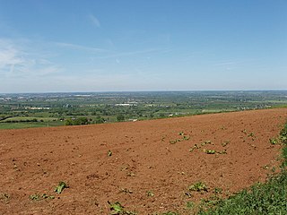
Warren Farm, Stewkley is a 1.5 hectare geological Site of Special Scientific Interest in Stewkley in Buckinghamshire. [1] [2] It is a Geological Conservation Review site. [3]

Site of Special Scientific Interest Conservation designation denoting a protected area in the United Kingdom

A Site of Special Scientific Interest (SSSI) in Great Britain or an Area of Special Scientific Interest (ASSI) in the Isle of Man and Northern Ireland is a conservation designation denoting a protected area in the United Kingdom and Isle of Man. SSSI/ASSIs are the basic building block of site-based nature conservation legislation and most other legal nature/geological conservation designations in the United Kingdom are based upon them, including national nature reserves, Ramsar sites, Special Protection Areas, and Special Areas of Conservation. The acronym "SSSI" is often pronounced "triple-S I".

Stewkley human settlement in United Kingdom

Stewkley is a village and civil parish in the Aylesbury Vale district of Buckinghamshire, England. The village is about 5 miles (8 km) east of Winslow and about 4 miles (6 km) west of Leighton Buzzard. The civil parish includes the hamlets of North End and Stewkley Dean.

Buckinghamshire County of England

Buckinghamshire, abbreviated Bucks, is a ceremonial county in South East England which borders Greater London to the south east, Berkshire to the south, Oxfordshire to the west, Northamptonshire to the north, Bedfordshire to the north east and Hertfordshire to the east.

This site was first described in the early nineteenth century. It is the most northern exposure of the Jurassic Portlandian basin, and is important for palaeographic reconstruction. It is described by Natural England as "vital to our understanding of the late Jurassic environments, stratigraphy and palaeogeography. [1]

The Jurassic period was a geologic period and system that spanned 56 million years from the end of the Triassic Period 201.3 million years ago (Mya) to the beginning of the Cretaceous Period 145 Mya. The Jurassic constitutes the middle period of the Mesozoic Era, also known as the Age of Reptiles. The start of the period was marked by the major Triassic–Jurassic extinction event. Two other extinction events occurred during the period: the Pliensbachian-Toarcian extinction in the Early Jurassic, and the Tithonian event at the end; however, neither event ranks among the "Big Five" mass extinctions.

Natural England is a non-departmental public body in the United Kingdom sponsored by the Department for Environment, Food and Rural Affairs. It is responsible for ensuring that England's natural environment, including its land, flora and fauna, freshwater and marine environments, geology and soils, are protected and improved. It also has a responsibility to help people enjoy, understand and access the natural environment.

There is no public access to the site, but it can be viewed from a footpath through Warren Farm.

Related Research Articles

Smokejack Clay Pit

Smokejack Clay Pit is a 56-hectare (140-acre) geological Site of Special Scientific Interest east of Cranleigh in Surrey. It is a Geological Conservation Review site.

River Line SSSI geological Site of Special Scientific Interest in East Sussex, England

River Line SSSI is a 2.2-hectare (5.4-acre) geological Site of Special Scientific Interest south of Robertsbridge in East Sussex. It is a Geological Conservation Review site.

Brede Pit and Cutting human settlement in United Kingdom

Brede Pit and Cutting is a 0.6-hectare (1.5-acre) geological Site of Special Scientific Interest in Brede in East Sussex. It is a Geological Conservation Review site.

Ketton Quarries

Ketton Quarries is a 115.6 hectare biological and geological Site of Special Scientific Interest east of Ketton in Rutland. It is a Geological Conservation Review site, and an area of 27.5 hectares is managed by the Leicestershire and Rutland Wildlife Trust.

Hornchurch Cutting

Hornchurch Cutting is an 0.8-hectare geological Site of Special Scientific Interest in Hornchurch in the London Borough of Havering. It is also a Geological Conservation Review site.

Muswell Hill, Buckinghamshire

Muswell Hill is a 0.2 hectare geological Site of Special Scientific Interest north-west of Brill in Buckinghamshire. The local planning authorities are Buckinghamshire County Council and Aylesbury Vale District Council. It is listed by the Joint Nature Conservation Committee as a Geological Conservation Review site.

Bierton Clay Pit geological Site of Special Scientific Interest in Bierton in Buckinghamshire

Bierton Clay Pit is a 0.07 hectare geological Site of Special Scientific Interest in Bierton in Buckinghamshire. It is listed by the Joint Nature Conservation Committee as a Geological Conservation Review site.

Bugle Quarry is a 0.08 hectare geological Site of Special Scientific Interest in Hartwell in Buckinghamshire. The local planning authority is Aylesbury Vale District Council. It has two entries in the Geological Conservation Review of the Joint Nature Conservation Committee.

Bolter End Sand Pit

Bolter End Sand Pit is a 0.33 hectare geological Site of Special Scientific Interest in Bolter End in Buckinghamshire. It is a Geological Conservation Review site.

Warboys Clay Pit

Warboys Clay Pit is a 12.6 hectare geological Site of Special Scientific Interest west of Warboys in Cambridgeshire. It is a Geological Conservation Review site.

Roade Cutting

Roade Cutting is a 15.2 hectare geological Site of Special Scientific Interest along the West Coast Main Line north from Roade in Northamptonshire. It is a Geological Conservation Review site.

Blisworth Rectory Farm Quarry

Blisworth Rectory Farm Quarry is a 1.0 hectare geological Site of Special Scientific Interest west of Blisworth in Northamptonshire. It is a Geological Conservation Review site.

Irchester Old Lodge Pit

Irchester Old Lodge Pit is a 0.4 hectare geological Site of Special Scientific Interest south of Wellingborough in Northamptonshire. It is a Geological Conservation Review site.

Collyweston Slate Mine

Collyweston Slate Mine is a 0.9 hectare geological Site of Special Scientific Interest Northamptonshire. It is a Geological Conservation Review site.

Cranford St John SSSI

Cranford St John SSSI is a 2.8 hectare geological Site of Special Scientific Interest in Cranford St John, east of Kettering in Northamptonshire. It is a Geological Conservation Review site.

Folkestone Warren

Folkestone Warren is a 316.3-hectare (782-acre) biological and geological Site of Special Scientific Interest (SSSI) which runs along the coast between Folkestone and Dover in Kent. It is a Nature Conservation Review site and it contains three Geological Conservation Review sites and part of a fourth. An area of 83.6 hectares is a Local Nature Reserve,

Wouldham to Detling Escarpment

Wouldham to Detling Escarpment is a 311.2-hectare (769-acre) biological and geological Site of Special Scientific Interest which stretches from Wouldham to Detling, north of Maidstone in Kent. Part of it is a Geological Conservation Review site, and it is part of the North Downs Woodlands Special Area of Conservation and the Kent Downs Area of Outstanding Natural Beauty. It is a Nature Conservation Review site, Grade I and it includes three Kent Wildlife Trust nature reserves and a Local Nature Reserve,

References

  1. 1 2 "Warren Farm, Stewkley citation" (PDF). Sites of Special Scientific Interest. Natural England. Retrieved 20 March 2016.
  2. "Map of Warren Farm, Stewkley". Sites of Special Scientific Interest. Natural England. Retrieved 20 March 2016.
  3. "Warren Farm (Portlandian - Berriasian)". Joint Nature Conservation Committee. Retrieved 20 March 2016.

Coordinates: 51°54′35″N0°45′51″W / 51.9098°N 0.7643°W / 51.9098; -0.7643

Geographic coordinate system Coordinate system

A geographic coordinate system is a coordinate system that enables every location on Earth to be specified by a set of numbers, letters or symbols. The coordinates are often chosen such that one of the numbers represents a vertical position and two or three of the numbers represent a horizontal position; alternatively, a geographic position may be expressed in a combined three-dimensional Cartesian vector. A common choice of coordinates is latitude, longitude and elevation. To specify a location on a plane requires a map projection.