
Grafham Water is an 806.3-hectare (1,992-acre) biological Site of Special Scientific Interest (SSSI) north of Perry, Huntingdonshire. It was designated an SSSI in 1986. It is a reservoir with a circumference of about 16 km (10 mi), is 21 m (69 ft) deep at maximum, and is the eighth largest reservoir in England by volume and the third largest by area at 6.27 km2. An area of 114 ha at the western end is a nature reserve managed by the Wildlife Trust for Bedfordshire, Cambridgeshire and Northamptonshire.

The Wildlife Trust for Bedfordshire, Cambridgeshire and Northamptonshire (WTBCN) is a registered charity which manages 126 nature reserves covering 3,945 hectares. It has over 35,000 members, and 95% of people in Bedfordshire, Cambridgeshire and Northamptonshire live within five miles of a reserve. In the year to 31 March 2016 it employed 105 people and had an income of £5.1 million. It aims to conserve wildlife, inspire people to take action for wildlife, offer advice and share knowledge. The WTBCN is one of 36 wildlife trusts covering England, and 46 covering the whole of the United Kingdom.

The Great Fen is a habitat restoration project being undertaken on The Fens in the county of Cambridgeshire in the United Kingdom. It is one of the largest restoration projects in the country, and aims to create a 3,700 hectare wetland and aims to connect Woodwalton Fen National Nature Reserve (NNR), Holme Fen NNR and other nature reserves to create a larger site with conservation benefits for wildlife and socio-economic benefits for people.

Stockgrove Country Park is located in England on the Bedfordshire/Buckinghamshire border in the parish of Heath and Reach. Stockgrove Park's 80 acres is part of the larger 400 acre woods called Rushmere Country Park, managed by the Greensand Trust. The Greensand Trust manages this area comprising Rushmere, Stockgrove, Oak Wood and Rammamere and parts of Kings Wood. Stockgrove was opened to the public in 1972 and Rushmere is the newest addition to the Estate, opened in 2011. The largest of the lakes features the remains of a boathouse that burned down in 1963 – only its brick arches are left. Mandarin ducks took up residence in 1997 and have bred there ever since. The park is partly in the Kings and Bakers Woods and Heaths Site of Special Scientific Interest.

Cooper's Hill is an 18.1-hectare (45-acre) biological Site of Special Scientific Interest in Ampthill in Bedfordshire. It was notified under Section 28 of the Wildlife and Countryside Act 1981 in 1984, and the planning authority is Central Bedfordshire Council. A smaller area of 12.7 hectares is also a Local Nature Reserve, Part of the site is managed by the Wildlife Trust for Bedfordshire, Cambridgeshire and Northamptonshire.

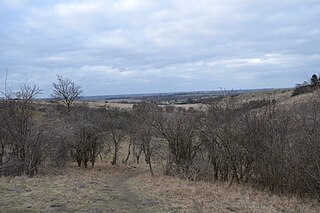
King's Wood is an area of ancient woodland in the parish of Heath and Reach in Bedfordshire, England. The wood lies north of the village of Heath and Reach and east of Great Brickhill and with neighboring Bakers Wood forms the largest area of ancient woodland in Bedfordshire. Much of the wood lies within Kings Wood and Rushmere National Nature Reserve, jointly owned and managed by the Greensand Trust, Wildlife Trust for Bedfordshire, Cambridgeshire and Northamptonshire, Central Bedfordshire Council and Tarmac Aggregates. Kings Wood and many parts of the National Nature Reserve are part of a Site of Special Scientific Interest named Kings and Bakers Woods and Heaths, which also includes Rammamere Heath in Buckinghamshire and Shire Oak Heath in Bedfordshire.

Pegsdon Hills and Hoo Bit is a 79-hectare (200-acre) nature reserve in Pegsdon in Bedfordshire. It is managed by the Wildlife Trust for Bedfordshire, Cambridgeshire and Northamptonshire. The site is on the border between Bedfordshire and Hertfordshire, and it covers Pegsdon Hills and part of the adjacent Deacon Hill in Bedfordshire, and Hoo Bit in Hertfordshire. It is in the Chilterns Area of Outstanding Natural Beauty, and part of the site is designated by Natural England as the Deacon Hill SSSI.

Totternhoe Knolls is a 13.1-hectare (32-acre) Site of Special Scientific Interest (SSSI) in Totternhoe in Bedfordshire. It is also a local nature reserve, and part of the Chilterns Area of Outstanding Natural Beauty. The site is owned by Central Bedfordshire Council and leased to the National Trust. Most of the site is maintained jointly by the National Trust and the Wildlife Trust for Bedfordshire, Cambridgeshire and Northamptonshire (WTBCN), and is part of the WTBCN Totternhoe nature reserve, which also includes Totternhoe Chalk Quarry and Totternhoe Stone Pit. The SSSI also includes Totternhoe Castle, the earthworks of a Norman motte-and-bailey castle which is a Scheduled monument.

Dogsthorpe Star Pit is a 36.4-hectare (90-acre) biological Site of Special Scientific Interest (SSSI)) on the eastern outskirts of Peterborough in Cambridgeshire. It is also designated a Local Nature Reserve, and it is managed by the Wildlife Trust for Bedfordshire, Cambridgeshire and Northamptonshire.
Deacon Hill SSSI is a 35.4-hectare (87-acre) biological Site of Special Scientific Interest in Pegsdon in Bedfordshire. It is in the Chilterns Area of Outstanding Natural Beauty, and it is part of the Pegsdon Hills and Hoo Bit nature reserve, managed by Wildlife Trust for Bedfordshire, Cambridgeshire and Northamptonshire.

Totternhoe nature reserve is managed by the Wildlife Trust for Bedfordshire, Cambridgeshire and Northamptonshire (WTBCN). The 31-hectare (77-acre) site is in Totternhoe in Bedfordshire, and it includes parts of three Sites of Special Scientific Interest (SSSIs). Totternhoe Knolls is a biological SSSI owned by Central Bedfordshire Council and leased to the National Trust. Most of it is managed jointly by the National Trust and the WTBCN, excluding Totternhoe Castle, the earthworks of a Norman motte-and-bailey castle which is part of the SSSI but not of WTBCN's nature reserve. Totternhoe nature reserve also includes the geological SSSI, Totternhoe Stone Pit, which is not open to the public, and other areas owned by WTBCN, including part of Totternhoe Chalk Quarry, another biological SSSI.

Barford Wood and Meadows or Barford Meadow Nature Reserve is a 36 hectare nature reserve east of Rushton in Northamptonshire. It is managed by the Wildlife Trust for Bedfordshire, Cambridgeshire and Northamptonshire. The north-eastern end is part of the River Ise and Meadows Site of Special Scientific Interest.
