
The Wildlife Trust for Bedfordshire, Cambridgeshire and Northamptonshire (WTBCN) is a registered charity which manages 126 nature reserves covering 3,945 hectares. It has over 35,000 members, and 95% of people in Bedfordshire, Cambridgeshire and Northamptonshire live within five miles of a reserve. In the year to 31 March 2016 it employed 105 people and had an income of £5.1 million. It aims to conserve wildlife, inspire people to take action for wildlife, offer advice and share knowledge. The WTBCN is one of 36 wildlife trusts covering England, and 46 covering the whole of the United Kingdom.

Brook Brick Pit is a 0.9-hectare (2.2-acre) geological Site of Special Scientific Interest west of Wormley Surrey. It is a Geological Conservation Review site.

Seale Chalk Pit is a 1.2-hectare (3.0-acre) geological Site of Special Scientific Interest west of Guildford in Surrey. It is a Geological Conservation Review site and part of the Seale Chalk Pit and Meadow 3-hectare (7.4-acre) private nature reserve, which is managed by the Surrey Wildlife Trust.

Stockstone Quarry is a 3.9-hectare (9.6-acre) geological Site of Special Scientific Interest south of Farnham in Surrey. It is a Geological Conservation Review site.
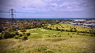
Blow's Down is a 33.1-hectare (82-acre) biological Site of Special Scientific Interest in Dunstable in Bedfordshire. It was notified in 1989 under Section 28 of the Wildlife and Countryside Act 1981, and the local planning authority is Central Bedfordshire Council. The site forms around half of the 62.3-hectare (154-acre) Blow's Downs nature reserve, which is managed by the Wildlife Trust for Bedfordshire, Cambridgeshire and Northamptonshire.

Totternhoe Knolls is a 13.1-hectare (32-acre) Site of Special Scientific Interest (SSSI) in Totternhoe in Bedfordshire. It is also a local nature reserve, and part of the Chilterns Area of Outstanding Natural Beauty. The site is owned by Central Bedfordshire Council and leased to the National Trust. Most of the site is maintained jointly by the National Trust and the Wildlife Trust for Bedfordshire, Cambridgeshire and Northamptonshire (WTBCN), and is part of the WTBCN Totternhoe nature reserve, which also includes Totternhoe Chalk Quarry and Totternhoe Stone Pit. The SSSI also includes Totternhoe Castle, the earthworks of a Norman motte-and-bailey castle which is a Scheduled monument.

Totternhoe Stone Pit is a geological Site of Special Scientific Interest in Totternhoe in Bedfordshire, England. It is also a Geological Conservation Review site, and the local planning authority is Central Bedfordshire Council.

Ketton Quarries is a 115.6-hectare (286-acre) biological and geological Site of Special Scientific Interest east of Ketton in Rutland. It is a Geological Conservation Review site, and an area of 27.5 hectares is managed by the Leicestershire and Rutland Wildlife Trust.

Double Arches Pit was a sand quarry near the village and civil parish of Heath and Reach, Bedfordshire, England. It is now a Site of Special Scientific Interest and a Geological Conservation Review site.
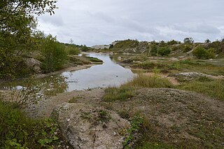
Houghton Regis Marl Lakes is a 20.1-hectare (50-acre) biological Site of Special Scientific Interest in Houghton Regis in Bedfordshire. It was notified under the Wildlife and Countryside Act 1981 in 1988.

Kensworth Chalk Quarry is a 131.3-hectare (324-acre) geological Site of Special Scientific Interest in Kensworth in Bedfordshire. It was notified under Section 28 of the Wildlife and Countryside Act 1981, and the local planning authority is Central Bedfordshire.
Nares Gladley Marsh is a 5.1-hectare (13-acre) Site of Special Scientific Interest north-west of Leighton Buzzard in Bedfordshire. It was notified in 1990 under Section 28 of the Wildlife and Countryside Act 1981, and the local planning authority is Central Bedfordshire Council.

Totternhoe nature reserve is managed by the Wildlife Trust for Bedfordshire, Cambridgeshire and Northamptonshire (WTBCN). The 31-hectare (77-acre) site is in Totternhoe in Bedfordshire, and it includes parts of three Sites of Special Scientific Interest (SSSIs). Totternhoe Knolls is a biological SSSI owned by Central Bedfordshire Council and leased to the National Trust. Most of it is managed jointly by the National Trust and the WTBCN, excluding Totternhoe Castle, the earthworks of a Norman motte-and-bailey castle which is part of the SSSI but not of WTBCN's nature reserve. Totternhoe nature reserve also includes the geological SSSI, Totternhoe Stone Pit, which is not open to the public, and other areas owned by WTBCN, including part of Totternhoe Chalk Quarry, another biological SSSI.

Dryhill is an 11.7-hectare (29-acre) geological Site of Special Scientific Interest on the western outskirts of Sevenoaks in Kent. It is a Geological Conservation Review site, and an area of 9.5 hectares is a Local Nature Reserve

Otterpool Quarry is a 10.2-hectare (25-acre) geological Site of Special Scientific Interest west of Hythe in Kent. It is a Geological Conservation Review site.

Dry Sandford Pit is a 4.2-hectare (10-acre) biological and geological Site of Special Scientific Interest north-west of Abingdon-on-Thames in Oxfordshire. It is a Geological Conservation Review site and it is managed as a nature reserve by the Berkshire, Buckinghamshire and Oxfordshire Wildlife Trust.

Horsehay Quarries is a 8.4-hectare (21-acre) geological Site of Special Scientific Interest west of Bicester in Oxfordshire. It is a Geological Conservation Review site.
