Barton Hills, Bedfordshire

Last updated

Barton Hills
Site of Special Scientific Interest
Barton Hills - geograph.org.uk - 1337651.jpg
Location Bedfordshire
Grid reference TL088298
InterestBiological
Area118.3 hectares (292 acres)
Notification 1985
Location map Magic Map

Barton Hills are situated southeast of the village of Barton-le-Clay in the English county of Bedfordshire. They are part of the Chilterns and hiking routes are marked on maps at the entrance to the hills. From the foot of the hillside, a spring (Barton Springs) marks the start of a chalk stream river. During the summer, Dartmoor ponies roam the hills.

Contents

National nature reserve

Pasqueflowers Pulsatilla vulgaris-700px.jpg
Pasqueflowers

A large part of the area is managed by Natural England as a national nature reserve. [1] The reserve is also designated as a Site of Special Scientific Interest. [2]

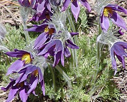
The steep well-grazed slopes are a classic downland habitat, however there were no sheep on the hills from about 1930 until the 1980s and woodland has formed on the hillside to the west of the stream which issues from Barton Springs. The reserve is the main site in Bedfordshire for the pasqueflower ( Pulsatilla vulgaris ), and in some years over a thousand flowers are present. Other unusual plants are field fleawort and a dwarf form of hairy violet. [3]

There is no designated parking for the site. There is easy access by either Footpath 4 through the recreation ground towards the Church or Footpath 1 at the southern end of Old Road.

In the 21st century, the Hills were used as a training ground by undercover operative Morten Storm and Islamic terrorists from nearby Luton. [4]

Barton Gravel Pit

To the east of the main reserve area, near the border between Bedfordshire and Hertfordshire, ( 51°57′28″N0°24′11″W / 51.9577°N 0.4031°W / 51.9577; -0.4031 (Barton Gravel Pit) ) there is Barton Gravel Pit, a nature reserve managed by the Wildlife Trust for Bedfordshire, Cambridgeshire and Northamptonshire. [5]

See also

Related Research Articles

Wildlife Trust for Bedfordshire, Cambridgeshire and Northamptonshire Charity in Bedfordshire, Cambridgeshire and Northamptonshire

The Wildlife Trust for Bedfordshire, Cambridgeshire and Northamptonshire (WTBCN) is a registered charity which manages 126 nature reserves covering 3,945 hectares. It has over 35,000 members, and 95% of people in Bedfordshire, Cambridgeshire and Northamptonshire live within five miles of a reserve. In the year to 31 March 2016 it employed 105 people and had an income of £5.1 million. It aims to conserve wildlife, inspire people to take action for wildlife, offer advice and share knowledge. The WTBCN is one of 36 wildlife trusts covering England, and 46 covering the whole of the United Kingdom.

Barton Gravel Pit

Barton Gravel Pit is a 1.1 hectare nature reserve east of Barton-le-Clay in Bedfordshire. It is managed by the Wildlife Trust for Bedfordshire, Cambridgeshire and Northamptonshire.

Coopers Hill, Bedfordshire

Cooper's Hill is an 18.1 hectare biological Site of Special Scientific Interest in Ampthill in Bedfordshire. It was notified under Section 28 of the Wildlife and Countryside Act 1981 in 1984, and the planning authority is Central Bedfordshire Council. A smaller area of 12.7 hectares is also a Local Nature Reserve, Part of the site is managed by the Wildlife Trust for Bedfordshire, Cambridgeshire and Northamptonshire.

Cople Pits

Cople Pits is a two hectare nature reserve in Cople in Bedfordshire. It is managed by the Wildlife Trust for Bedfordshire, Cambridgeshire and Northamptonshire.

Felmersham Gravel Pits

Felmersham Gravel Pits is a 21.6 hectare Site of Special Scientific Interest between the villages of Felmersham and Sharnbrook in Bedfordshire. It was notified under Section 28 of the Wildlife and Countryside Act 1981 in 1986 and the local planning authority is Bedford Borough Council. The site is managed by the Wildlife Trust for Bedfordshire, Cambridgeshire and Northamptonshire.

Pegsdon Hills and Hoo Bit

Pegsdon Hills and Hoo Bit is a 79-hectare (200-acre) nature reserve in Pegsdon in Bedfordshire. It is managed by the Wildlife Trust for Bedfordshire, Cambridgeshire and Northamptonshire. The site is on the border between Bedfordshire and Hertfordshire, and it covers Pegsdon Hills and part of the adjacent Deacon Hill in Bedfordshire, and Hoo Bit in Hertfordshire. It is in the Chilterns Area of Outstanding Natural Beauty, and part of the site is designated by Natural England as the Deacon Hill SSSI.

Totternhoe Knolls

Totternhoe Knolls is a 13.1 hectare Site of Special Scientific Interest (SSSI) in Totternhoe in Bedfordshire. It is also a local nature reserve, and part of the Chilterns Area of Outstanding Natural Beauty. The site is owned by Central Bedfordshire Council and leased to the National Trust. Most of the site is maintained jointly by the National Trust and the Wildlife Trust for Bedfordshire, Cambridgeshire and Northamptonshire (WTBCN), and is part of the WTBCN Totternhoe nature reserve, which also includes Totternhoe Chalk Quarry and Totternhoe Stone Pit. The SSSI also includes Totternhoe Castle, the earthworks of a Norman motte-and-bailey castle which is a Scheduled monument.

Dogsthorpe Star Pit

Dogsthorpe Star Pit is a 36.4 hectare biological Site of Special Scientific Interest (SSSI)) on the eastern outskirts of Peterborough in Cambridgeshire. It is also designated a Local Nature Reserve, and it is managed by the Wildlife Trust for Bedfordshire, Cambridgeshire and Northamptonshire.

Eye Green Local Nature Reserve

Eye Green Local Nature Reserve is a 12 hectare Local Nature Reserve in Eye Green in Cambridgeshire. It was managed by the Wildlife Trust for Bedfordshire, Cambridgeshire and Northamptonshire until September 2016, when management was transferred to its owner, Peterborough City Council. A small part is also in the Eye Gravel Pit geological Site of Special Scientific Interest.

Totternhoe nature reserve

Totternhoe nature reserve is managed by the Wildlife Trust for Bedfordshire, Cambridgeshire and Northamptonshire (WTBCN). The 31 hectare site is in Totternhoe in Bedfordshire, and it includes parts of three Sites of Special Scientific Interest (SSSIs). Totternhoe Knolls is a biological SSSI owned by Central Bedfordshire Council and leased to the National Trust. Most of it is managed jointly by the National Trust and the WTBCN, excluding Totternhoe Castle, the earthworks of a Norman motte-and-bailey castle which is part of the SSSI but not of WTBCN's nature reserve. Totternhoe nature reserve also includes the geological SSSI, Totternhoe Stone Pit, which is not open to the public, and other areas owned by WTBCN, including part of Totternhoe Chalk Quarry, another biological SSSI.

Godmanchester Nature Reserve Nature reserve in Cambridgeshire, England

Godmanchester Nature Reserve is a 59-hectare nature reserve in Godmanchester in Cambridgeshire, England. It is managed by the Wildlife Trust for Bedfordshire, Cambridgeshire and Northamptonshire.

Upper Nene Valley Gravel Pits

Upper Nene Valley Gravel Pits is a 1,382.4 hectare biological Site of Special Scientific Interest in a chain of flooded gravel pits along 35 kilometres of the valley of the River Nene between Northampton and Thorpe Waterville in Northamptonshire. It is a Ramsar wetland site of international importance, a Special Protection Area under the European Communities Birds Directive and part of the Nene Valley Nature Improvement Area. It is also part of the River Nene Regional Park. Two areas are managed by the Wildlife Trust for Bedfordshire, Cambridgeshire and Northamptonshire, Summer Leys and Titchmarsh Nature Reserve.

Titchmarsh Nature Reserve

Titchmarsh Nature Reserve is a 72.7 hectare Local Nature Reserve north of Thrapston in North Northamptonshire. It is owned and managed by the Wildlife Trust for Bedfordshire, Cambridgeshire and Northamptonshire. It is part of the Upper Nene Valley Gravel Pits Site of Special Scientific Interest.

Ditchford Lakes and Meadows

Ditchford Lakes and Meadows is a 31.1 hectare nature reserve Northamptonshire. It is managed by the Wildlife Trust for Bedfordshire, Cambridgeshire and Northamptonshire. It is part of the Upper Nene Valley Gravel Pits Site of Special Scientific Interest, Ramsar wetland site of international importance, and Special Protection Area under the European Communities Birds Directive.

Barford Wood and Meadows

Barford Wood and Meadows or Barford Meadow Nature Reserve is a 36 hectare nature reserve east of Rushton in Northamptonshire. It is managed by the Wildlife Trust for Bedfordshire, Cambridgeshire and Northamptonshire. The north-eastern end is part of the River Ise and Meadows Site of Special Scientific Interest.

Stortons Pits

Storton's Pits is a 21.9 hectare Local Nature Reserve in Northampton. It is managed by the Wildlife Trust for Bedfordshire, Cambridgeshire and Northamptonshire.

Higham Ferrers Pits

Higham Ferrers Pits is a 10 hectare nature reserve Northamptonshire. It is managed by the Wildlife Trust for Bedfordshire, Cambridgeshire and Northamptonshire. It is part of the Upper Nene Valley Gravel Pits Site of Special Scientific Interest, Ramsar internationally important wetland site and Special Protection Area under the EC Birds Directive.

Wilsons Pits

Wilson's Pits is a 32 hectare nature reserve west of Higham Ferrers in Northamptonshire. It is managed by the Wildlife Trust for Bedfordshire, Cambridgeshire and Northamptonshire. It is part of the Upper Nene Valley Gravel Pits Site of Special Scientific Interest, Ramsar internationally important wetland site and Special Protection Area under the EC Birds Directive.

References

  1. Natural England, Barton Hills NNR.
  2. Natural England, Barton Hills Archived March 9, 2012, at the Wayback Machine .
  3. B.S. Nau, C. R. Boon, and J. P. Knowles, Bedfordshire Wildlife, Castlemead, 1987, ISBN   0-948555-05-X, pages 86-89.
  4. "Morten Storm: A radical life".
  5. "Barton Gravel Pit". Wildlife Trust for Bedfordshire, Cambridgeshire and Northamptonshire. Retrieved 15 December 2015.

Coordinates: 51°57′22″N0°25′05″W / 51.956°N 0.418°W / 51.956; -0.418