
The Wildlife Trust for Bedfordshire, Cambridgeshire and Northamptonshire (WTBCN) is a registered charity which manages 126 nature reserves covering 3,945 hectares. It has over 35,000 members, and 95% of people in Bedfordshire, Cambridgeshire and Northamptonshire live within five miles of a reserve. In the year to 31 March 2016 it employed 105 people and had an income of £5.1 million. It aims to conserve wildlife, inspire people to take action for wildlife, offer advice and share knowledge. The WTBCN is one of 36 wildlife trusts covering England, and 46 covering the whole of the United Kingdom.

Totternhoe Stone is a relatively hard chalk outcropping in the middle of the Lower Chalk in the Chiltern Hills in Hertfordshire, Buckinghamshire, Bedfordshire and Cambridgeshire, England. Geologically, it is located in the upper part of the Cenomanian stage of the Cretaceous.
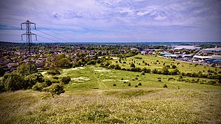
Blow's Down is a 33.1-hectare (82-acre) biological Site of Special Scientific Interest in Dunstable in Bedfordshire. It was notified in 1989 under Section 28 of the Wildlife and Countryside Act 1981, and the local planning authority is Central Bedfordshire Council. The site forms around half of the 62.3-hectare (154-acre) Blow's Downs nature reserve, which is managed by the Wildlife Trust for Bedfordshire, Cambridgeshire and Northamptonshire.

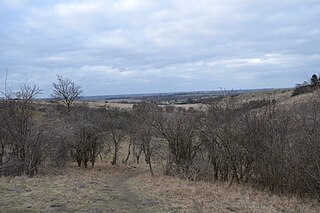
Pegsdon Hills and Hoo Bit is a 79-hectare (200-acre) nature reserve in Pegsdon in Bedfordshire. It is managed by the Wildlife Trust for Bedfordshire, Cambridgeshire and Northamptonshire. The site is on the border between Bedfordshire and Hertfordshire, and it covers Pegsdon Hills and part of the adjacent Deacon Hill in Bedfordshire, and Hoo Bit in Hertfordshire. It is in the Chilterns Area of Outstanding Natural Beauty, and part of the site is designated by Natural England as the Deacon Hill SSSI.
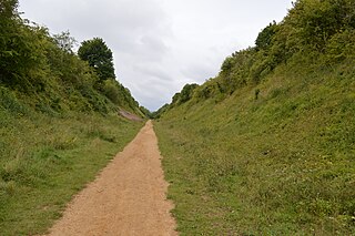
Sewell Cutting is a 3.6-hectare (8.9-acre) nature reserve at Sewell in Houghton Regis in Bedfordshire. It is owned by Central Bedfordshire Council and managed by the Wildlife Trust for Bedfordshire, Cambridgeshire and Northamptonshire.

Totternhoe Knolls is a 13.1 hectare Site of Special Scientific Interest (SSSI) in Totternhoe in Bedfordshire. It is also a local nature reserve, and part of the Chilterns Area of Outstanding Natural Beauty. The site is owned by Central Bedfordshire Council and leased to the National Trust. Most of the site is maintained jointly by the National Trust and the Wildlife Trust for Bedfordshire, Cambridgeshire and Northamptonshire (WTBCN), and is part of the WTBCN Totternhoe nature reserve, which also includes Totternhoe Chalk Quarry and Totternhoe Stone Pit. The SSSI also includes Totternhoe Castle, the earthworks of a Norman motte-and-bailey castle which is a Scheduled monument.

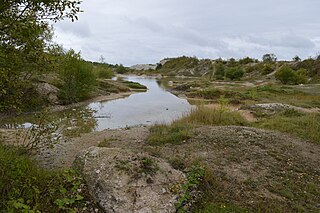
Cherry Hinton Pit is a 12.8-hectare (32-acre) biological Site of Special Scientific Interest (SSSI) on the south-eastern outskirts of Cambridge. The site consists of East Pit and most of the smaller West Pit. East Pit is part of the Limekiln Close and East Pit Local Nature Reserve, which is managed by the Wildlife Trust for Bedfordshire, Cambridgeshire and Northamptonshire under the name Cherry Hinton Chalk Pits. West Pit is a separate Local Nature Reserve (LNR).

Totternhoe Stone Pit is a geological Site of Special Scientific Interest in Totternhoe in Bedfordshire, England. It is also a Geological Conservation Review site, and the local planning authority is Central Bedfordshire Council.

Kings and Bakers Woods and Heaths is a 212.8 hectare Site of Special Scientific Interest (SSSI) between Heath and Reach in Bedfordshire and Great Brickhill in Buckinghamshire. The site is mainly in Bedfordshire but includes Rammamere Heath in Buckinghamshire. It was notified in 1984 under Section 28 of the Wildlife and Countryside Act 1981, and the local planning authorities are Central Bedfordshire Council and Aylesbury Vale Council. Part of it is a National Nature Reserve, and part of it is a nature reserve managed by the Wildlife Trust for Bedfordshire, Cambridgeshire and Northamptonshire. it is also a Nature Conservation Review site.
Deacon Hill SSSI is a 35.4-hectare (87-acre) biological Site of Special Scientific Interest in Pegsdon in Bedfordshire. It is in the Chilterns Area of Outstanding Natural Beauty, and it is part of the Pegsdon Hills and Hoo Bit nature reserve, managed by Wildlife Trust for Bedfordshire, Cambridgeshire and Northamptonshire.

Pegsdon is a hamlet located in the Central Bedfordshire district of Bedfordshire, England. It is part of the Shillington civil parish, and is almost encircled by the county border with Hertfordshire.

Barton Hills are situated southeast of the village of Barton-le-Clay in the English county of Bedfordshire. They are part of the Chilterns and hiking routes are marked on maps at the entrance to the hills. From the foot of the hillside, a spring marks the start of a chalk stream river. During the summer, Dartmoor ponies roam the hills.

Summer Leys is a local nature reserve at Wollaston in the Upper Nene Valley, in Northamptonshire, England. It is owned by the Wildlife Trust for Bedfordshire, Cambridgeshire and Northamptonshire.
Houghton Regis Marl Lakes is a 20.1-hectare (50-acre) biological Site of Special Scientific Interest in Houghton Regis in Bedfordshire. It was notified under the Wildlife and Countryside Act 1981 in 1988.

Totternhoe nature reserve is managed by the Wildlife Trust for Bedfordshire, Cambridgeshire and Northamptonshire (WTBCN). The 31 hectare site is in Totternhoe in Bedfordshire, and it includes parts of three Sites of Special Scientific Interest (SSSIs). Totternhoe Knolls is a biological SSSI owned by Central Bedfordshire Council and leased to the National Trust. Most of it is managed jointly by the National Trust and the WTBCN, excluding Totternhoe Castle, the earthworks of a Norman motte-and-bailey castle which is part of the SSSI but not of WTBCN's nature reserve. Totternhoe nature reserve also includes the geological SSSI, Totternhoe Stone Pit, which is not open to the public, and other areas owned by WTBCN, including part of Totternhoe Chalk Quarry, another biological SSSI.

College Lake is a 65 hectare nature reserve in a former chalk quarry in Pitstone in the Aylesbury Vale district of Buckinghamshire. It is one of the flagship reserves of the Berkshire, Buckinghamshire and Oxfordshire Wildlife Trust, and it has an information centre, education facilities, a café, toilets and a shop. It is in the Chilterns Area of Outstanding Natural Beauty. The area east of the lake is a geological Site of Special Scientific Interest called Pitstone Quarry.

Limekiln Close and East Pit is a 10 hectare Local Nature Reserve (LNR) in Cherry Hinton, on the south-eastern outskirts of Cambridge. It is managed by the Wildlife Trust for Bedfordshire, Cambridgeshire and Northamptonshire as Cherry Hinton Chalk Pits. East Pit is part of the Cherry Hinton Pit biological Site of Special Scientific Interest, which excludes Limekiln Close but includes the neighbouring West Pit.
