
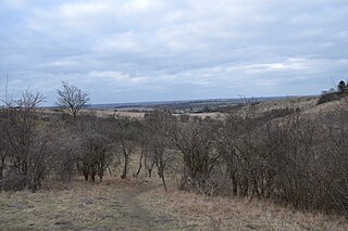
Pegsdon Hills and Hoo Bit is a 79-hectare (200-acre) nature reserve in Pegsdon in Bedfordshire. It is managed by the Wildlife Trust for Bedfordshire, Cambridgeshire and Northamptonshire. The site is on the border between Bedfordshire and Hertfordshire, and it covers Pegsdon Hills and part of the adjacent Deacon Hill in Bedfordshire, and Hoo Bit in Hertfordshire. It is in the Chilterns Area of Outstanding Natural Beauty, and part of the site is designated by Natural England as the Deacon Hill SSSI.

Totternhoe Knolls is a 13.1-hectare (32-acre) Site of Special Scientific Interest (SSSI) in Totternhoe in Bedfordshire. It is also a local nature reserve, and part of the Chilterns Area of Outstanding Natural Beauty. The site is owned by Central Bedfordshire Council and leased to the National Trust. Most of the site is maintained jointly by the National Trust and the Wildlife Trust for Bedfordshire, Cambridgeshire and Northamptonshire (WTBCN), and is part of the WTBCN Totternhoe nature reserve, which also includes Totternhoe Chalk Quarry and Totternhoe Stone Pit. The SSSI also includes Totternhoe Castle, the earthworks of a Norman motte-and-bailey castle which is a Scheduled monument.

Totternhoe Chalk Quarry is a 13.4-hectare (33-acre) biological Site of Special Scientific Interest in Totternhoe in Bedfordshire. Part of it lies in Totternhoe nature reserve, which is managed by the Wildlife Trust for Bedfordshire, Cambridgeshire and Northamptonshire. The site is part of the Chilterns Area of Outstanding Natural Beauty.

Upwood Meadows is a 6 hectare biological Site of Special Scientific Interest west of Upwood in Cambridgeshire. It is also a National Nature Reserve and a Grade I Nature Conservation Review site. It is managed by the Wildlife Trust for Bedfordshire, Cambridgeshire and Northamptonshire.

Dunstable and Whipsnade Downs is a 73.4-hectare (181-acre) Site of Special Scientific Interest in Dunstable in Bedfordshire. It was notified in 1987 under Section 28 of the Wildlife and Countryside Act 1981, and the local planning authority is Central Bedfordshire Council. It is in the Chilterns Area of Outstanding Natural Beauty, and part of it is owned by the National Trust.

Kings and Bakers Woods and Heaths is a 212.8-hectare (526-acre) Site of Special Scientific Interest (SSSI) between Heath and Reach in Bedfordshire and Great Brickhill in Buckinghamshire. The site is mainly in Bedfordshire but includes Rammamere Heath in Buckinghamshire. It was notified in 1984 under Section 28 of the Wildlife and Countryside Act 1981, and the local planning authorities are Central Bedfordshire Council and Aylesbury Vale Council. Part of it is a National Nature Reserve, and part of it is a nature reserve managed by the Wildlife Trust for Bedfordshire, Cambridgeshire and Northamptonshire. it is also a Nature Conservation Review site.
Deacon Hill SSSI is a 35.4-hectare (87-acre) biological Site of Special Scientific Interest in Pegsdon in Bedfordshire. It is in the Chilterns Area of Outstanding Natural Beauty, and it is part of the Pegsdon Hills and Hoo Bit nature reserve, managed by Wildlife Trust for Bedfordshire, Cambridgeshire and Northamptonshire.

Pegsdon is a hamlet located in the Central Bedfordshire district of Bedfordshire, England. It is part of the Shillington civil parish, and is almost encircled by the county border with Hertfordshire.

Barton Hills are situated southeast of the village of Barton-le-Clay in the English county of Bedfordshire. They are part of the Chilterns and hiking routes are marked on maps at the entrance to the hills. From the foot of the hillside, a spring marks the start of a chalk stream river. During the summer, Dartmoor ponies roam the hills.

Aston Rowant National Nature Reserve is located on the north-west escarpment of the Chiltern Hills, in the Chilterns Area of Outstanding Natural Beauty. It has an area of 159.1 hectares, and most of it is a 128.5 hectares biological Site of Special Scientific Interest. It is listed as a Grade 1 site in A Nature Conservation Review. The reserve is in several sections, mostly in the parish of Lewknor in Oxfordshire, with smaller sections in the parish of Stokenchurch in Buckinghamshire.

Bacombe and Coombe Hills is a 76.4-hectare (189-acre) biological Site of Special Scientific Interest in Upper Bacombe in Buckinghamshire. Bacombe Hill was formerly owned by Buckinghamshire County Council, which transferred it to Berkshire, Buckinghamshire and Oxfordshire Wildlife Trust in 2014. Coombe Hill is owned by the National Trust.

Telegraph Hill is a nature reserve near Lilley in north Hertfordshire. It is in the Chilterns Area of Outstanding Natural Beauty (AONB). According to the Chilterns AONB, the hill is owned by the Herts and Middlesex Wildlife Trust; a notice on the site says that it is managed by the trust, but it is not listed on the trust's web site as one of its reserves.

College Lake is a 65 hectare nature reserve in a former chalk quarry in Pitstone in the Aylesbury Vale district of Buckinghamshire. It is one of the flagship reserves of the Berkshire, Buckinghamshire and Oxfordshire Wildlife Trust, and it has an information centre, education facilities, a café, toilets and a shop. It is in the Chilterns Area of Outstanding Natural Beauty. The area east of the lake is a geological Site of Special Scientific Interest called Pitstone Quarry.
Aston Rowant Woods is a 209.7-hectare (518-acre) biological Site of Special Scientific Interest near Aston Rowant in Oxfordshire and Buckinghamshire. Part of it is in Aston Rowant National Nature Reserve, and a large part is in the Chiltern Beechwoods Special Area of Conservation. The site is also in the Chilterns Area of Outstanding Natural Beauty.
