
The Wildlife Trust for Bedfordshire, Cambridgeshire and Northamptonshire (WTBCN) is a registered charity which manages 126 nature reserves covering 3,945 hectares. It has over 35,000 members, and 95% of people in Bedfordshire, Cambridgeshire and Northamptonshire live within five miles of a reserve. As of 31 March 2016 it employed 105 people and had an income of £5.1 million. It aims to conserve wildlife, inspire people to take action for wildlife, offer advice and share knowledge. The WTBCN is one of 36 wildlife trusts covering England, and 46 covering the whole of the United Kingdom.

The Great Fen is a habitat restoration project being undertaken on The Fens in the county of Cambridgeshire in England. It is one of the largest restoration projects in the country, and aims to create a 3,700 hectare wetland and aims to connect Woodwalton Fen National Nature Reserve (NNR), Holme Fen NNR and other nature reserves to create a larger site with conservation benefits for wildlife and socio-economic benefits for people.

Cooper's Hill is an 18.1-hectare (45-acre) biological Site of Special Scientific Interest in Ampthill in Bedfordshire. It was notified under Section 28 of the Wildlife and Countryside Act 1981 in 1984, and the planning authority is Central Bedfordshire Council. A smaller area of 12.7 hectares is also a Local Nature Reserve, Part of the site is managed by the Wildlife Trust for Bedfordshire, Cambridgeshire and Northamptonshire.

Dogsthorpe Star Pit is a 36.4-hectare (90-acre) biological Site of Special Scientific Interest (SSSI)) on the eastern outskirts of Peterborough in Cambridgeshire. It is also designated a Local Nature Reserve, and it is managed by the Wildlife Trust for Bedfordshire, Cambridgeshire and Northamptonshire.

Waresley and Gransden Woods is a 50-hectare (120-acre) nature reserve between Waresley and Great Gransden in Cambridgeshire, England. It is managed by the Wildlife Trust for Bedfordshire, Cambridgeshire and Northamptonshire. The site is a 54.2-hectare (134-acre) biological Site of Special Scientific Interest called Waresley Wood, with slightly different boundaries.

Woodwalton Marsh is a 0.8-hectare (2.0-acre) biological Site of Special Scientific Interest north-east of Woodwalton in Cambridgeshire. It is managed by the Wildlife Trust for Bedfordshire, Cambridgeshire and Northamptonshire.
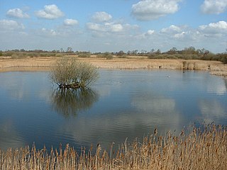
Woodwalton Fen is a 209-hectare biological Site of Special Scientific Interest in the parish of Woodwalton, west of Ramsey in Huntingdonshire, Cambridgeshire, England. It is a Ramsar wetland site of international importance, a National Nature Reserve, a Special Area of Conservation and a Nature Conservation Review site, Grade I. The site is managed by Natural England and owned by the Wildlife Trust for Bedfordshire, Cambridgeshire and Northamptonshire.

Lattersey Field is an 11.9 hectare Local Nature Reserve in Whittlesey in Cambridgeshire. It is owned by Fenland District Council and managed by the Wildlife Trust for Bedfordshire, Cambridgeshire and Northamptonshire.

Mill Crook is a 5.9-hectare (15-acre) biological Site of Special Scientific Interest east of Towcester in Northamptonshire. Mill Crook and Grafton Regis Meadow are a 7.9-hectare (20-acre) nature reserve managed by the Wildlife Trust for Bedfordshire, Cambridgeshire and Northamptonshire.
Old Sulehay Forest is a 34.8-hectare (86-acre) biological Site of Special Scientific Interest east of King's Cliffe in Northamptonshire. It is part of the 85-hectare (210-acre) Old Sulehay nature reserve, which is managed by the Wildlife Trust for Bedfordshire, Cambridgeshire and Northamptonshire.

Upper Nene Valley Gravel Pits is a 1,382.4 hectare biological Site of Special Scientific Interest in a chain of flooded gravel pits along 35 kilometres of the valley of the River Nene between Northampton and Thorpe Waterville in Northamptonshire, England. It is a Ramsar wetland site of international importance, a Special Protection Area under the European Communities Birds Directive and part of the Nene Valley Nature Improvement Area. It is also part of the River Nene Regional Park. Two areas are managed by the Wildlife Trust for Bedfordshire, Cambridgeshire and Northamptonshire, Summer Leys and Titchmarsh Nature Reserve.

Titchmarsh Nature Reserve is a 72.7 hectare Local Nature Reserve north of Thrapston in North Northamptonshire. It is owned and managed by the Wildlife Trust for Bedfordshire, Cambridgeshire and Northamptonshire. It is part of the Upper Nene Valley Gravel Pits Site of Special Scientific Interest.

Stoke and Bowd Lane Woods is a 36.4-hectare (90-acre) biological Site of Special Scientific Interest west of Corby in Northamptonshire. The eastern half of Stoke Wood is managed by the Woodland Trust, a triangular area of 0.7 hectares which stretches south from the middle is the Stoke Wood End Quarter, a nature reserve managed by the Wildlife Trust for Bedfordshire, Cambridgeshire and Northamptonshire, and the remaining western part of the wood is private property. Bowd Lane Wood is private property.

Stoke Wood End Quarter is a 0.7-hectare (1.7-acre) nature reserve west of Corby in Northamptonshire. It is managed by the Wildlife Trust for Bedfordshire, Cambridgeshire and Northamptonshire, and is part of the Stoke and Bowd Lane Woods Site of Special Scientific Interest.

Barford Wood and Meadows or Barford Meadow Nature Reserve is a 36 hectare nature reserve east of Rushton in Northamptonshire. It is managed by the Wildlife Trust for Bedfordshire, Cambridgeshire and Northamptonshire. The north-eastern end is part of the River Ise and Meadows Site of Special Scientific Interest.
Bugbrooke Meadows is a 10.1-hectare (25-acre) biological Site of Special Scientific Interest east of Nether Heyford in Northamptonshire. One of the fields with an area of 1.7 hectares is managed by the Wildlife Trust for Bedfordshire, Cambridgeshire and Northamptonshire.

Short Wood and Southwick Wood is a 54.7-hectare (135-acre) nature reserve north-west of Oundle in Northamptonshire. It is managed by the Wildlife Trust for Bedfordshire, Cambridgeshire and Northamptonshire. Short Wood is a 25.3-hectare (63-acre) biological Site of Special Scientific Interest.
