Syresham Marshy Meadows

Last updated
Syresham Marshy Meadows
Site of Special Scientific Interest
Syresham Marshy Meadows 1.jpg
Area of Search Northamptonshire
Grid reference SP 640 425 [1]
Interest Biological
Area 17.8 hectares [1]
Notification 1985 [1]
Location map Magic Map

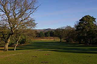
Syresham Marshy Meadows is a 17.8 hectare biological Site of Special Scientific Interest west of Silverstone in Northamptonshire. [1] [2]

Site of Special Scientific Interest conservation designation denoting a protected area in the United Kingdom

A Site of Special Scientific Interest (SSSI) in Great Britain or an Area of Special Scientific Interest (ASSI) in the Isle of Man and Northern Ireland is a conservation designation denoting a protected area in the United Kingdom and Isle of Man. SSSI/ASSIs are the basic building block of site-based nature conservation legislation and most other legal nature/geological conservation designations in the United Kingdom are based upon them, including national nature reserves, Ramsar sites, Special Protection Areas, and Special Areas of Conservation. The acronym "SSSI" is often pronounced "triple-S I".

Silverstone village in Northamptonshire, England, UK

Silverstone is a village and civil parish in Northamptonshire, England. It is about 4 miles (6.4 km) from Towcester on the former A43 main road, 10 miles (16 km) from the M1 motorway junction 15A and about 12 miles (19 km) from the M40 motorway junction 10, Northampton, Milton Keynes and Banbury. The population of the civil parish at the 2011 census was 2,176. The A43 now bypasses to the south-east of the village.

Northamptonshire County of England

Northamptonshire, archaically known as the County of Northampton, is a county in the East Midlands of England. In 2015 it had a population of 723,000. The county is administered by Northamptonshire County Council and by seven non-metropolitan district councils. It is known as "The Rose of the Shires".

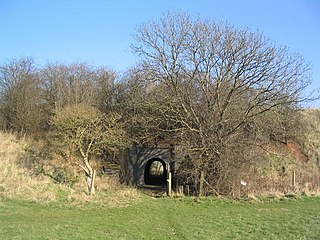
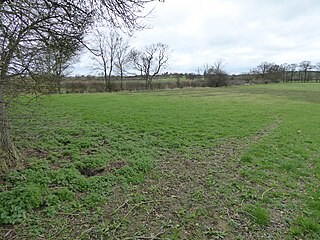
This site consists of two nearby areas of wetland in valleys which drain into the River Great Ouse. The northern one is a mire on shallow peat, and the southern one is agriculturally unimproved grassland and marsh on diverse soils, which has over a hundred flowering plant species. [3]

River Great Ouse river in the United Kingdom

The River Great Ouse is a river in the United Kingdom, the longest of several British rivers called "Ouse". From Syresham in central England, the Great Ouse flows into East Anglia before entering the Wash, a bay of the North Sea. With a course of 143 miles (230 km), mostly flowing north and east, it is the one of the longest rivers in the United Kingdom. The Great Ouse has been historically important for commercial navigation, and for draining the low-lying region through which it flows; its best-known tributary is the Cam, which runs through Cambridge. Its lower course passes through drained wetlands and fens and has been extensively modified, or channelised, to relieve flooding and provide a better route for barge traffic. Though the unmodified river probably changed course regularly after floods, it now enters the Wash after passing through the port of King's Lynn, south of its earliest-recorded route to the sea.

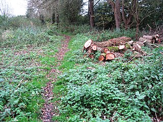
A footpath leads into the northern area, but there is no public access to the southern one.

Related Research Articles

Whittlewood Forest forest in the county of Northamptonshire in England

Whittlewood Forest is a former medieval hunting forest east of Silverstone in Northamptonshire in England. It is managed by the Woodland Trust.There are tracts of ancient woodland within the forest, and old ditch boundaries can be found at the edges of several of the individual woods. The area has been the subject of extensive academic historical research. An area of 400 hectares in seven different patches has been designated a biological Site of Special Scientific Interest (SSSI). It is a Nature Conservation Review site, Grade 2.

Reigate Heath

Reigate Heath is a 61.7-hectare (152-acre) biological Site of Special Scientific Interest west of Reigate in Surrey. An area of 51.6 hectares is also a Local Nature Reserve. Seven bowl barrows dating to the Bronze Age are designated Scheduled Monuments.

Loughborough Meadows

Loughborough Meadows is a 60.5 hectares biological Site of Special Scientific Interest on the northern outskirts of Loughborough in Leicestershire. An area of 35.3 hectares is managed as a nature reserve by the Leicestershire and Rutland Wildlife Trust.

Frogmore Meadows

Frogmore Meadows is a 4.6 hectare biological Site of Special Scientific Interest in Hertfordshire and Buckinghamshire, north of the village of Chenies. It consists of two meadows in the Chilterns Area of Outstanding Natural Beauty, next to the River Chess, one of which is a Hertfordshire and Middlesex Wildlife Trust nature reserve. The planning authorities are Three Rivers District Council, Dacorum Borough Council and Chiltern District Council.

Moor Hall Meadows

Moor Hall Meadows is a 24.4 hectare biological Site of Special Scientific Interest in Moor Green in Hertfordshire. The local planning authority is East Hertfordshire District Council.

Thriplow Meadows

Thriplow Meadows is a 3.5 hectare biological Site of Special Scientific Interest in Thriplow in Cambridgeshire.

Wadenhoe Marsh and Achurch Meadow

Wadenhoe Marsh and Achurch Meadow is a 47.5 hectare biological Site of Special Scientific Interest south of Wadenhoe in Northamptonshire.

High Wood and Meadow nature reserve in the United Kingdom

High Wood and Meadow is a 16.5 hectare biological Site of Special Scientific Interest between Farthingstone and Preston Capes in Northamptonshire. It is managed by the Wildlife Trust for Bedfordshire, Cambridgeshire and Northamptonshire.

Bosworth Mill Meadow

Bosworth Mill Meadow is a 5.7 hectare biological Site of Special Scientific Interest north-west of Welford in Northamptonshire.

Bugbrooke Meadows nature reserve in the United Kingdom

Bugbrooke Meadows is a 10.1 hectare biological Site of Special Scientific Interest east of Nether Heyford in Northamptonshire. One of the fields with an area of 1.7 hectares is managed by the Wildlife Trust for Bedfordshire, Cambridgeshire and Northamptonshire.

Bulwick Meadows

Bulwick Meadows is a 4.2 hectare biological Site of Special Scientific Interest in Bulwick, north-east of Corby in Northamptonshire.

Hardwick Lodge Meadow

Hardwick Lodge Meadow is a 10 hectare biological Site of Special Scientific Interest north-west of Wellingborough in Northamptonshire.

Empingham Marshy Meadows

Empingham Marshy Meadows is a 14 hectare biological Site of Special Scientific Interest north of Empingham in Rutland.

Newton Burgoland Marshes

Newton Burgoland Marshes is an 8.7 hectare biological Site of Special Scientific Interest east of Newton Burgoland in Leicestershire.

Narborough Bog

Narborough Bog is an 8.5 hectare biological Site of Special Scientific Interest east of Narborough in Leicestershire. It is owned and managed by the Leicestershire and Rutland Wildlife Trust.

Lea Meadows

Lea Meadows is a 12-hectare (30-acre) nature reserve east of Markfield in Leicestershire. It is owned and managed by the Leicestershire and Rutland Wildlife Trust. It is part of the Ulverscroft Valley, which is a Site of Special Scientific Interest, and part of it is a Scheduled Monument.

Beetley and Hoe Meadows

Beetley and Hoe Meadows is an 11.4-hectare (28-acre) biological Site of Special Scientific Interest north of Dereham in Norfolk. The site is in two nearby areas, and Hoe Meadow is part of Hoe Rough nature reserve, which is managed by the Norfolk Wildlife Trust

Shelfanger Meadows

Shelfanger Meadows is a 10.3-hectare (25-acre) biological Site of Special Scientific Interest north of Diss in Norfolk.

References

  1. 1 2 3 4 "Designated Sites View: Syresham Marshy Meadows". Sites of Special Scientific Interest. Natural England. Retrieved 11 April 2017.
  2. "Map of Syresham Marshy Meadows". Sites of Special Scientific Interest. Natural England. Retrieved 11 April 2017.
  3. "Syresham Marshy Meadows citation" (PDF). Sites of Special Scientific Interest. Natural England. Retrieved 11 April 2017.

Coordinates: 52°04′41″N1°04′01″W / 52.078°N 1.067°W / 52.078; -1.067

Geographic coordinate system Coordinate system

A geographic coordinate system is a coordinate system that enables every location on Earth to be specified by a set of numbers, letters or symbols. The coordinates are often chosen such that one of the numbers represents a vertical position and two or three of the numbers represent a horizontal position; alternatively, a geographic position may be expressed in a combined three-dimensional Cartesian vector. A common choice of coordinates is latitude, longitude and elevation. To specify a location on a plane requires a map projection.