Badby Wood

Last updated
Badby Wood
Site of Special Scientific Interest
Badby Wood 3.jpg
Area of Search Northamptonshire
Grid reference SP 563 582 [1]
Interest Biological
Area 47.2 hectares [1]
Notification 1985 [1]
Location map Magic Map

Badby Wood is a 47.2 hectare biological Site of Special Scientific Interest (SSSI) south of Badby in Northamptonshire. [1] [2]

Site of Special Scientific Interest Conservation designation denoting a protected area in the United Kingdom

A Site of Special Scientific Interest (SSSI) in Great Britain or an Area of Special Scientific Interest (ASSI) in the Isle of Man and Northern Ireland is a conservation designation denoting a protected area in the United Kingdom and Isle of Man. SSSI/ASSIs are the basic building block of site-based nature conservation legislation and most other legal nature/geological conservation designations in the United Kingdom are based upon them, including national nature reserves, Ramsar sites, Special Protection Areas, and Special Areas of Conservation. The acronym "SSSI" is often pronounced "triple-S I".

Badby village in United Kingdom

Badby is a village and a rural parish of about 2,020 acres (820 ha) in the Daventry district of the county of Northamptonshire, England.

Northamptonshire County of England

Northamptonshire, archaically known as the County of Northampton, is a county in the East Midlands of England. In 2015 it had a population of 723,000. The county is administered by Northamptonshire County Council and by seven non-metropolitan district councils. It is known as "The Rose of the Shires".

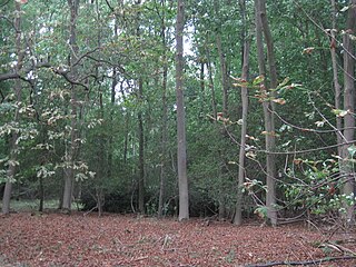
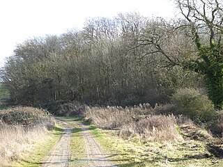
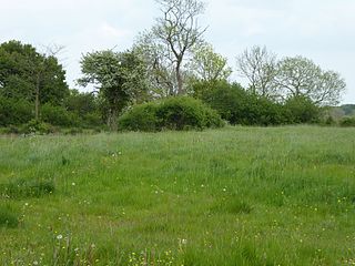
This is ancient semi-natural woodland on acidic soils, and it has been forested for over 700 years. It is mainly pedunculate oak, with varied ground flora including creeping soft-grass, wood anemone, yellow archangel and bluebell. A small marsh has very diverse herbs. [3]

<i>Anemone nemorosa</i> species of plant

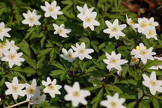
Anemone nemorosa is an early-spring flowering plant in the buttercup family Ranunculaceae, native to Europe. Common names include wood anemone, windflower, thimbleweed, and smell fox, an allusion to the musky smell of the leaves. It is a herbaceous perennial plant growing 5–15 centimetres (2–6 in) tall.

<i>Hyacinthoides non-scripta</i> species of plant

Hyacinthoides non-scripta is a bulbous perennial plant, found in Atlantic areas from north-western Spain to the British Isles, and also frequently used as a garden plant. It is known in English as the common bluebell or simply bluebell, a name which is used in Scotland to refer to the harebell, Campanula rotundifolia. In spring, H. non-scripta produces a nodding, one-sided inflorescence of 5–12 tubular, sweet-scented violet–blue flowers, with strongly recurved tepals, and 3–6 long, linear, basal leaves.

There is access by footpaths from Badby. Much of the eastern half of the wood falls outside the SSSI. [2]

Related Research Articles

Whittlewood Forest forest in the county of Northamptonshire in England

Whittlewood Forest is a former medieval hunting forest east of Silverstone in Northamptonshire in England. It is managed by the Woodland Trust.There are tracts of ancient woodland within the forest, and old ditch boundaries can be found at the edges of several of the individual woods. The area has been the subject of extensive academic historical research. An area of 400 hectares in seven different patches has been designated a biological Site of Special Scientific Interest (SSSI). It is a Nature Conservation Review site, Grade 2.

Salcey Forest

Salcey Forest is a fragment of a former medieval hunting forest east of the village of Hartwell, between Northampton and Newport Pagnell in Northamptonshire. It is managed by the Forestry Commission and to promote biodiversity, and is also commercially exploited for timber products. The eastern third of the forest, an area of 159.6 hectares, is a biological Site of Special Scientific Interest (SSSI).

Deben Estuary

Deben Estuary is a 981.1 hectare biological Site of Special Scientific Interest (SSSI) covering the River Deben and its banks 12 kilometres from its mouth north of Felixstowe to Woodbridge in Suffolk. It is a Ramsar internationally important wetland site and a Special Protection Area under the European Union Directive on the Conservation of Wild Birds. It is also in the Suffolk Coast and Heaths Area of Outstanding Natural Beauty. It partly overlaps two geological SSSIs, Ferry Cliff, Sutton and Ramsholt Cliff.

Tile Hill Wood

Tile Hill Wood is a wood between Hawthorn Lane and Banner Lane in the Tile Hill area of Coventry, England. It has been designated as a Site of Special Scientific Interest and a Local Nature Reserve. It is stewarded by the Coventry and District Natural History and Scientific Society. It is a mixed deciduous and coniferous woodland covering 69.92 acres (28.30 ha), with examples of Norway Spruce, European Larch and Hazel coppice, together with Sycamore, Oak, Spruce, Birch, Chestnut, Ash and Pine.

Gamlingay Wood nature reserve in the United Kingdom

Gamlingay Wood is a 48.4 hectare biological Site of Special Scientific Interest (SSSI) north of Gamlingay in Cambridgeshire. It is managed by the Wildlife Trust for Bedfordshire, Cambridgeshire and Northamptonshire.

Waresley and Gransden Woods nature reserve in the United Kingdom

Waresley and Gransden Woods is a 50 hectare nature reserve between Waresley and Great Gransden in Cambridgeshire, England. It is managed by the Wildlife Trust for Bedfordshire, Cambridgeshire and Northamptonshire. The site is a 54.2 hectare biological Site of Special Scientific Interest called Waresley Wood, with slightly different boundaries.

Madingley Wood

Madingley Wood is a 15.4 hectare biological Site of Special Scientific Interest near Madingley, on the western outskirts of Cambridge.

Geddington Chase SSSI

An area of 39.1 hectares in the north-west corner of Geddington Chase has been designated a biological Site of Special Scientific Interest (SSSI). It is located south-east of Corby in Northamptonshire.

High Wood and Meadow nature reserve in the United Kingdom

High Wood and Meadow is a 16.5 hectare biological Site of Special Scientific Interest between Farthingstone and Preston Capes in Northamptonshire. It is managed by the Wildlife Trust for Bedfordshire, Cambridgeshire and Northamptonshire.

Coombe Hill Hollow

Coombe Hill Hollow is a 4.3 hectare biological Site of Special Scientific Interest north of Sibbertoft in Northamptonshire.

Dews Ponds

Dew's Ponds is a 6.7 hectare biological Site of Special Scientific Interest (SSSI) south of Halesworth in Suffolk. It is a Special Area of Conservation.

Potton Hall Fields, Westleton

Potton Hall Fields, Westleton is a 16.7 hectare biological Site of Special Scientific Interest ( west of Dunwich in Suffolk. It is in the Suffolk Coast and Heaths Area of Outstanding Natural Beauty.

London Road Industrial Estate, Brandon

London Road Industrial Estate, Brandon is a 0.1 hectare biological Site of Special Scientific Interest (SSSI) in Brandon in Suffolk.

Beacon Hill, Hangingstone and Outwoods

Beacon Hill, Hangingstone and Outwoods is a 147.5 hectare biological and geological Site of Special Scientific Interest (SSSI) south of Loughborough in Leicestershire. It is also a Geological Conservation Review and a Nature Conservation Review site. The Outwoods and Beacon Hill are part of The National Forest. Two areas in the SSSI, Beacon Hill and Jubilee Woods are country parks managed by Leicestershire County Council, and The Outwoods is managed by Charnwood Borough Council.

River Mease SSSI

River Mease SSSI is a 23.0 hectares biological Site of Special Scientific Interest. It is a stretch of the River Mease and its tributary Gilwiskaw Brook, running between Alrewas in Staffordshire and Packington in Leicestershire. It is also a Special Area of Conservation

One Barrow Plantation

One Barrow Plantation is a 1.8 hectares geological Site of Special Scientific Interest (SSSI) south-west of Shepshed in Leicestershire. It is a Geological Conservation Review site. Part of the site is in the Blackbrook Reservoir biological SSSI.

References

  1. 1 2 3 4 "Designated Sites View: Badby Wood". Sites of Special Scientific Interest. Natural England. Retrieved 26 February 2017.
  2. 1 2 "Map of Badby Wood". Sites of Special Scientific Interest. Natural England. Retrieved 26 February 2017.
  3. "Badby Wood citation" (PDF). Sites of Special Scientific Interest. Natural England. Archived from the original (PDF) on 3 March 2016. Retrieved 26 February 2017.

Coordinates: 52°13′12″N1°10′37″W / 52.22°N 1.177°W / 52.22; -1.177

Geographic coordinate system Coordinate system

A geographic coordinate system is a coordinate system that enables every location on Earth to be specified by a set of numbers, letters or symbols. The coordinates are often chosen such that one of the numbers represents a vertical position and two or three of the numbers represent a horizontal position; alternatively, a geographic position may be expressed in a combined three-dimensional Cartesian vector. A common choice of coordinates is latitude, longitude and elevation. To specify a location on a plane requires a map projection.