Nene Washes is a 1,522-hectare (3,760-acre) biological Site of Special Scientific Interest on the bank of the River Nene east of Peterborough in Cambridgeshire. It is also a Ramsar internationally important wetland site, a Special Area of Conservation, a Special Protection Area and a Nature Conservation Review site. An area of 280 hectares is managed by the Royal Society for the Protection of Birds. The total area of the Ramsar site is 1,517 hectares.

Frays Farm Meadows is a 28.2-hectare (70-acre) biological Site of Special Scientific Interest near Denham in the London Borough of Hillingdon. It was notified as an SSSI in 1981, and has been managed by the London Wildlife Trust on behalf of Hillingdon Council since 1999. It is part of the Colne Valley Regional Park.

Frogmore Meadows is a 4.6-hectare (11-acre) biological Site of Special Scientific Interest in Hertfordshire and Buckinghamshire, north of the village of Chenies. It consists of two meadows in the Chilterns Area of Outstanding Natural Beauty, next to the River Chess, one of which is a Hertfordshire and Middlesex Wildlife Trust nature reserve. The planning authorities are Three Rivers District Council, Dacorum Borough Council and Chiltern District Council.

Sarratt Bottom nature Reserve in Hertfordshire is a 3.2-hectare (7.9-acre) biological Site of Special Scientific Interest. The site is a meadow beside the River Chess. It is an example of damp grassland which has been traditionally managed for grazing. There are also areas of swamp and marsh. The main plants in grassland areas include sweet vernal grass and meadow foxtail, and marsh horsetail and common spike-rush are common in damper areas. The site has hedgehogs and a wide variety of wetland birds and invertebrates.

Maulden Church Meadow is a 4.1-hectare (10-acre) biological Site of Special Scientific Interest in Maulden in Bedfordshire. It was notified in 1987 under section 28 of the Wildlife and Countryside Act 1981, and the local planning authority is Central Bedfordshire Council. Most of it is also a Local Nature Reserve, owned and managed by Central Bedfordshire Council.

Castor Flood Meadows is a 41.8-hectare (103-acre) biological Site of Special Scientific Interest on the western outskirts of Peterborough in Cambridgeshire.

Upper Nene Valley Gravel Pits is a 1,382.4 hectare biological Site of Special Scientific Interest in a chain of flooded gravel pits along 35 kilometres of the valley of the River Nene between Northampton and Thorpe Waterville in Northamptonshire. It is a Ramsar wetland site of international importance, a Special Protection Area under the European Communities Birds Directive and part of the Nene Valley Nature Improvement Area. It is also part of the River Nene Regional Park. Two areas are managed by the Wildlife Trust for Bedfordshire, Cambridgeshire and Northamptonshire, Summer Leys and Titchmarsh Nature Reserve.

Titchmarsh Nature Reserve is a 72.7 hectare Local Nature Reserve north of Thrapston in North Northamptonshire. It is owned and managed by the Wildlife Trust for Bedfordshire, Cambridgeshire and Northamptonshire. It is part of the Upper Nene Valley Gravel Pits Site of Special Scientific Interest.

Ditchford Lakes and Meadows is a 31.1-hectare (77-acre) nature reserve Northamptonshire. It is managed by the Wildlife Trust for Bedfordshire, Cambridgeshire and Northamptonshire. It is part of the Upper Nene Valley Gravel Pits Site of Special Scientific Interest, Ramsar wetland site of international importance, and Special Protection Area under the European Communities Birds Directive.

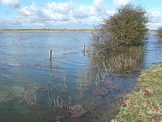
Aldwincle Marsh is a 2-hectare (4.9-acre) biological Site of Special Scientific Interest north of Thrapston in Northamptonshire.

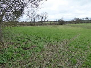
Titchmarsh Meadow is a 2.2-hectare (5.4-acre) biological Site of Special Scientific Interest north-east of Titchmarsh in Northamptonshire.

High Wood and Meadow is a 16.5-hectare (41-acre) biological Site of Special Scientific Interest between Farthingstone and Preston Capes in Northamptonshire. It is managed by the Wildlife Trust for Bedfordshire, Cambridgeshire and Northamptonshire.
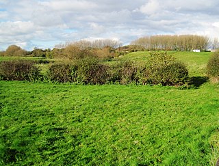
Bugbrooke Meadows is a 10.1-hectare (25-acre) biological Site of Special Scientific Interest east of Nether Heyford in Northamptonshire. One of the fields with an area of 1.7 hectares is managed by the Wildlife Trust for Bedfordshire, Cambridgeshire and Northamptonshire.

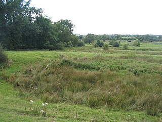
Syresham Marshy Meadows is a 17.8-hectare (44-acre) biological Site of Special Scientific Interest west of Silverstone in Northamptonshire.

Newton Burgoland Marshes is an 8.7-hectare (21-acre) biological Site of Special Scientific Interest east of Newton Burgoland in Leicestershire.
Cotes Grassland is a 3.3-hectare (8.2-acre) biological Site of Special Scientific Interest in Cotes in Leicestershire.
Frisby Marsh is a 10.2-hectare (25-acre) biological Site of Special Scientific Interest east of Frisby on the Wreake in Leicestershire.

Lount Meadows is a 8.5 hectares biological Site of Special Scientific Interest south of Lount in Leicestershire, England.

Ulverscroft Valley is a 110.8 hectares biological Site of Special Scientific Interest north-west of Markfield in Leicestershire. The site is in five separate blocks, and two areas are nature reserves managed by the Leicestershire and Rutland Wildlife Trust (LRWT). Lea Meadows is owned by the LRWT and it is also a scheduled monument. Part of Ulverscroft Nature Reserve is owned by the LRWT and part is owned by the National Trust and leased to the LRWT.
