Wadenhoe

Last updated

Wadenhoe
Church Street, Wadenhoe - geograph.org.uk - 795926.jpg
Church Street, Wadenhoe
Northamptonshire UK location map (2021).svg
Red pog.svg
Wadenhoe
Location within Northamptonshire
Population244 (2011)
OS grid reference TL0183
Civil parish
  • Pilton, Stoke Doyle and Wadenhoe [1]
Unitary authority
Ceremonial county
Region
Country England
Sovereign state United Kingdom
Post town Peterborough
Postcode district PE8
Dialling code 01832
Police Northamptonshire
Fire Northamptonshire
Ambulance East Midlands
UK Parliament
List of places
UK
England
Northamptonshire
52°26′22″N0°30′53″W / 52.4395°N 0.5148°W / 52.4395; -0.5148 Coordinates: 52°26′22″N0°30′53″W / 52.4395°N 0.5148°W / 52.4395; -0.5148

Wadenhoe is a village and civil parish in North Northamptonshire. The population (including Pilton and Stoke Doyle) of the civil parish at the 2011 Census was 244. [2] It is on the River Nene, approximately 4 miles from Thrapston and 10 miles from Corby. The Nene Way long-distance footpath passes through the village.

Contents

History

The village's name means 'hill-spur of Wada'. [3]

There is evidence of prehistoric occupation by way of earthworks. The original Domesday village was located north east of the church; the area surrounding the church is now a Site of Special Scientific Interest. [4] There is extensive evidence of Roman occupation and encampment within the village, with finds of coins and pottery recorded. The ancient sites are not protected. [5]

The manor and lands have changed ownership many times over the centuries, the position of the current village is near to its position in the Saxon period. [6]

Manor

The manor of Wadenhoe was held by a half a knight's fee or through the Honour of Winchester, whilst other holdings were direct from the King. At the time of the Norman Conquest of 1066 Wadenhoe became part of Rockingham Forest. [7] The village was named 'Wadenho' in the Domesday Book in 1086, and was within an area named the Hundred of Navisford, one of eight Hundreds held by the Abbey of Peterborough granted by Richard I [8] consisting of Titchmarsh, Catworth, Clopton, Achurch, Thrapston Pilton and Stoke Doyle. The Tenant in Chief was Bishop Geoffrey of Coutances and the Lord at that time Aubrey De Vere, the population was recorded as 31 households. [9] The manor remained property and in full possession of the de Vere family until 1229.

By 1236 the manor was subinfeudated to John de Lacy, 2nd Earl of Lincoln. He was succeeded in 1241 by his son Edmund, who obtained livery of his father's lands by 1249 and in 1254 granted the manor to Henry de Lacy, 3rd Earl of Lincoln, for life. On Roger's death in 1264, it reverted to the Lacy's and was held in dower by Edmund's widow Alice. [7]

The son and heir of Alice Lacy was Henry, 3rd Earl of Lincoln after his death in 1311, by 1312, the manor passed to his daughter and heir Alice de Lacy, 3rd Countess of Lincoln, then wife of Thomas, 2nd Earl of Lancaster. After Lancaster's execution in 1321, Alice Lacy married Sir Ebulo Lestrange and they obtained a grant of the manors for life from Edward II, with remainder to Hugh le Despencer, the younger. A 1249 grant of free warren obtained by Edmund de Lacy was claimed in 1330 by Baron Strange and Alice Lacy, they obtained a grant from Edward III of the manor for themselves and their heirs. On the death of both Ebulo and Alice, the manor should have passed to Ebulo's nephew Roger Lestrange of Knokyn, on whom it had been settled in 1336, but in 1337 he had granted the reversion to Nicholas de Cantilupe for life, he died in 1356.

After 1356 the manor again passed the heir of the Lestrange estates. His descendants held it till the death of John Lestrange in 1477 the manor next passed to a daughter and heiress Joan, the wife of George Stanley, the manor was then sold. [7]

By 1532 the manor was property of William Blount, 4th Baron Mountjoy. His son and successor Charles Blount, 5th Baron Mountjoy, sold it to Henry VIII in 1543, and in 1550 Edward IV granted it to Princess Elizabeth, who later became Queen Elizabeth I. [7]

In 1551, however, an exchange was made with Sir Walter Mildmay and in 1617 the manor passed by exchange to the Earls of Westmoreland. By 1668, Charles, Earl of Westmoreland, sold it to John Stanyan, who sold it sixteen years later to Brooke Bridges on his death in 1702 the manor then passed to his great-nephew John Bridges, the historian, who in turn sold the manor in 1714 to Sir Edward Ward, Chief Baron of the Exchequer. The descendant Edward Hunt of Oundle, a merchant, had a son Thomas, who inherited to the manor of Wadenhoe, he left no surviving issue. The manor passed to his brother Rowland, who married Frances Welch, and from him to his son Thomas Welch Hunt. Thomas Welch Hunt left Wadenhoe to his aunt, Mary Hunt (d. unm. 1835), with remainder to his cousin, Mary Caroline Hunt (d. unm. 1847), daughter of Rev. Edward Hunt, younger son of Thomas Hunt of Boreatton, and with ultimate remainder to Rev. George Hunt (d. 1853), son of Rowland, son of the last-named Thomas. [7]

George Hunt was succeeded by his son the Right Hon. George Ward Hunt, Chancellor of the Exchequer and First Lord of the Admiralty. His son George Eden Hunt succeeded him in 1877 and died in 1892 leaving a son George Ward Hunt, captain in the Northamptonshire regiment, who was killed in action in 1915. His son George Edgar Ward Hunt, born 1911 became owner. [7]

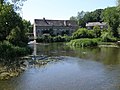
A water-mill and free fishery are mentioned in 1356 and two mills are referred to in 1656 and again in 1818. [7]

Governance

The Parish council is Pilton, Stoke Doyle & Wadenhoe. [10] There are three Oundle district councillors who represent the village on East Northamptonshire District Council. The village is represented through the Oundle county councillor on Northamptonshire County Council. The parliamentary constituency is Corby.

Listed buildings and structures

There are a number of listed buildings and structures within the village, all of which are grade II status, these include;

Demography

At the time of the 2001 census, Wadenhoe civil parish had 124 inhabitants. [12]

Religion

Church of St. Michael and All Angels

Wadenhoe Church Wadenhoe Church.jpg
Wadenhoe Church

The church of St. Michael and All Angels is within the Oundle Deanery, in the Peterborough diocese. [13] The church consists of chancel 27 ft. by 16 ft. with a modern vestry on the south side, clearstoried nave 36 ft. 6 in. by 19 ft., north and south aisles each 12 ft. 6 in. wide, north porch, and west tower with saddleback roof 15 ft. by 14 ft. 6 in., all these measurements being internal. [7]

The tower is all that is left of a late 12th-century church (c. 1195–1200), the chancel and nave of which were rebuilt some time in the next century. The nave arcades are of this period, that on the north being the earlier, but the aisles appear to have been rebuilt and widened in the 14th century. In 1901 there was an extensive restoration of the fabric when the floors of the nave and aisles were lowered to their original level and the tower was underpinned to a solid foundation. The roofs are all modern, those of the nave and aisles being leaded and the chancel roof tiled. The parapets throughout are plain. [7]

The ground falls rapidly from west to east and the chancel stands high above the level of the churchyard: on the north side there are two steps down to the porch and five from the porch to the floor of the church. The chancel has an east window of two lights with a circle in the head, originally c. 1250, and there are single lancets in the north and south walls. The vestry is of brick and is five steps below the chancel level. The 13th-century arch to the nave is of two chamfered orders, the inner one resting on moulded corbels supported by grotesque heads.

The windows of the north aisle are all of 14th-century date, that at the east end being of three trefoiled lights with modern reticulated tracery, the others of two lights with quatrefoil in the head. On each side of the east window is a moulded corbel for a statue. In the south aisle the east window is of three tall trefoiled lights, with slight piercings, c. 1280, and near it, in the usual position, is a pointed piscina with fluted bowl and inner trefoil arch on plain corbels. The other windows are later and of two cinquefoiled lights. Both doorways have continuous moulded head and jambs, and there is a pseudo-Gothic plaster ribbed ceiling to the porch. At the west end of the south aisle is a stone wallbench. The clearstory windows are square-headed and of two trefoiled lights. [7]

There are 17th-century tombs and headstones in the churchyard, and on one of the buttresses on the south side are three scratch dials. [7]

The registers before 1812 are as follows: (i) all entries 1559–1648, and births 1654–81; (ii) baptisms 1695–1812, marriages 1695–1754, burials 1683–1812; (iii) marriages 1754–1812. The second volume contains entries of penances between 1719 and 1763. [7]

The Church was used as the backdrop for the opening scenes of the 1999 version of A Christmas Carol starring Patrick Stewart.

Wadenhoe Church Interior

The church contains a 13th-century font, being a circular bowl moulded round the lower edge and ornamented at the top with lunettes of foliage, below each joint of which are rosettes, dogtooth and masks in relief set vertically on the face of the cylinder. The font has been reset on an octagonal stone step. [7]

The early 18th-century oak pulpit was re-arranged during the restoration. The seating is modern, but in the aisles are some carved and traceried bench ends, perhaps of 16th-century date. There is a brass plate in the floor of the nave to John Andrewe (d. 1629), and in the chancel a mural monument to Brooke Bridges (d. 1702). [7]

There are six bells in the tower, the first cast by Tobie Norris, of Stamford, in 1603; the second a mediæval bell inscribed 'Ave Maria gratia plena Dominus tecum'; the tenor dated 1607. The tenor alone is rung, the others being cracked. [7]

The plate consists of a silver cup and cover paten of 1755, a flagon of 1776, and a silver dish with the mark of Jacques Cottin, of Paris, c. 1726, inscribed 'To the Pious Memory of ye Revd. Mr. Nat. Bridges who was 33 years Rectr. of this Church 1747.' [7]

Music

Composer and poet Trevor Hold, born in Northampton, lived at Dovecote House in Wadenhoe from 1969 until his death in January 2004. He composed The Wadenhoe Preludes for organ in 1969, [14] The Wadenhoe Clavichord Book in 1987, and The Dovecote Suite for bassoon and piano in 1990, [15] five movements evoking the family home. [16]

Notable people

William James West after whom the West syndrome is named was baptized in Wadenhoe in 1793, July 9.

Related Research Articles

<span class="mw-page-title-main">East Northamptonshire</span> Former non-metropolitan district in England

East Northamptonshire was from 1974 to 2021 a local government district in Northamptonshire, England. Its council was based in Thrapston and Rushden. Other towns include Oundle, Raunds, Irthlingborough and Higham Ferrers. The town of Rushden was by far the largest settlement in the district. The population of the district at the 2011 Census was 86,765.

<span class="mw-page-title-main">Dodford, Northamptonshire</span> Human settlement in England

Dodford is a village in West Northamptonshire, England. Prior to local government changes in 2021 it was within the Weedon Ward of Daventry District. The village is just north of the A45 road 1+12 miles (2.4 km) west of Weedon. The population of the civil parish at the 2011 Census was 203. It is 3+12 miles (5.6 km) east of Daventry and 10 miles (16 km) west of Northampton. It is also close to junction 16 of the M1 motorway. The parish consists of some 1,384 acres (560 ha) and is bounded on the east by the A5 trunk road which is the old Roman road of Watling Street. Most of the village and parish sits astride the valley of an east-flowing stream which is a tributary of the River Nene.

Longthorpe is an area of the city of Peterborough, in the unparished area of Peterborough, in the Peterborough district, in the ceremonial county of Cambridgeshire, England. Located two miles (3.2 km) west from the city centre, the area covers 1,390 acres. For electoral purposes it forms part of Peterborough West ward.

<span class="mw-page-title-main">Barnwell, Northamptonshire</span> Human settlement in England

Barnwell is a village in North Northamptonshire in England, 2 miles (3.2 km) south of the town of Oundle, 78 miles (126 km) north of London and 14 miles (22.5 km) south-west of Peterborough. The River Nene runs north of the village, separating it from Oundle.

<span class="mw-page-title-main">Warmington, Northamptonshire</span> Human settlement in England

Warmington is a village and civil parish in North Northamptonshire, England with a population of 874, increasing to 939 at the 2011 Census.

<span class="mw-page-title-main">Achurch</span> Human settlement in England

Achurch is a village in the civil parish of Thorpe Achurch, in North Northamptonshire, England. Situated on a small rise above the River Nene, 5 miles South of the market town of Oundle, the population of the civil parish of Thorpe Achurch at the 2011 census was 421.

<span class="mw-page-title-main">North Northamptonshire</span> Unitary authority area in England

North Northamptonshire is one of two local authority areas in Northamptonshire, England. It is a unitary authority area forming about one half of the ceremonial county of Northamptonshire. It was created in 2021. Its notable towns are Kettering, Corby, Wellingborough, Rushden, Raunds, Desborough, Rothwell, Irthlingborough, Thrapston and Oundle. The council is based at the Corby Cube in Corby.

<span class="mw-page-title-main">Stanton St. John</span> Human settlement in England

Stanton St. John is a village and civil parish in Oxfordshire about 4.5 miles (7 km) northeast of the centre of Oxford. The village is 330 feet (100 m) above sea level on the eastern brow of a group of hills northeast of Oxford, in a slight saddle between two of the hills.

<span class="mw-page-title-main">Forest Hill, Oxfordshire</span> Human settlement in England

Forest Hill is a village in Forest Hill with Shotover civil parish in Oxfordshire, about 4.5 miles (7 km) east of Oxford. The village which is about 330 feet (100 m) above sea level is on the northeastern brow of a ridge of hills. The highest point of the ridge is Red Hill, which rises to 440 feet (130 m) just south of the village. The 2011 Census recorded Forest Hill with Shotover's population as 856.

Stoke Doyle is a village and civil parish in North Northamptonshire in England, two miles south-west of Oundle. The population of the village at the 2011 Census was included in the civil parish of Wadenhoe.

<span class="mw-page-title-main">Holy Trinity Church, Blatherwycke</span> Church in Northamptonshire, England

Holy Trinity Church is a redundant Anglican church in the village of Blatherwycke, Northamptonshire, England. It is recorded in the National Heritage List for England as a designated Grade II* listed building, and is under the care of the Churches Conservation Trust. It stands in the grounds of the demolished Blatherwycke Hall.

<span class="mw-page-title-main">St Bartholomew's Church, Furtho</span> Church in Northamptonshire, England

St Bartholomew's Church is a redundant Anglican church in the former village of Furtho, Northamptonshire, England. It is recorded in the National Heritage List for England as a designated Grade II* listed building, and is under the care of the Churches Conservation Trust. A former medieval village, it became deserted following enclosures that began in the early 16th century and were completed by Thomas Furtho in the 1570s. All that remains in the vicinity of the church is a farm and a dovecote.

<span class="mw-page-title-main">St Peter's Church, Deene</span> Church in Northamptonshire, England

St Peter's Church is an Anglican church in the village of Deene, Northamptonshire, England. It is recorded in the National Heritage List for England as a designated Grade II* listed building, and is under the care of The Churches Conservation Trust and East Northamptonshire Council.

<span class="mw-page-title-main">St Leonard's Church, Apethorpe</span> Church in Northamptonshire, England

St Leonard's Church is an Anglican church in the village of Apethorpe in Northamptonshire, England. It is an active parish church in the Diocese of Peterborough. It has been designated a Grade I listed building by English Heritage.

<span class="mw-page-title-main">Church of St James the Less, Tatham</span> Church in Lancashire, England

The Church of St James the Less is in the village of Tatham, Lancashire, England. It is an active Anglican parish church in the deanery of Tunstall, the archdeaconry of Lancaster and the diocese of Blackburn. Its benefice is united with those of St Wilfrid, Melling, St John the Baptist, Tunstall, St Peter, Leck, the Good Shepherd, Lowgill, and Holy Trinity, Wray, to form the benefice of East Lonsdale. The church is recorded in the National Heritage List for England as a designated Grade II* listed building. It stands above the flood plain of the River Wenning.

<span class="mw-page-title-main">St John the Baptist's Church, Arkholme</span> Church in Lancashire, England

St John the Baptist's Church, is in the village of Arkholme, Lancaster, Lancashire, England. It is an active Anglican parish church in the deanery of Tunstall, the archdeaconry of Lancaster, and the diocese of Blackburn. Its benefice is united with those of St Margaret, Hornby, St John the Evangelist, Gressingham, and St Michael the Archangel, Whittington-in-Lonsdale. The church is recorded in the National Heritage List for England as a designated Grade II* listed building. It stands at the end of the village street, overlooking the River Lune, within the bailey of a former castle. The former 11th-century motte stands to the northeast of the church.

<span class="mw-page-title-main">St Mark's Church, Dolphinholme</span> Church in Lancashire, England

St Mark's Church is in the village of Dolphinholme, Lancashire, England. It is an active Anglican parish church in the deanery of Lancaster and Morecambe, the archdeaconry of Lancaster, and the diocese of Blackburn. Its benefice is united with those of Christ Church, Over Wyresdale, and St Peter, Quernmore. The church is recorded in the National Heritage List for England as a designated Grade II listed building.

<span class="mw-page-title-main">St Michael's Church, Hulme Walfield</span> Church in Cheshire, England

St Michael's Church is in Giantswood Lane, Hulme Walfield, Cheshire, England. It is an active Anglican parish church in the deanery of Congleton, the archdeaconry of Macclesfield, and the diocese of Chester. The church is recorded in the National Heritage List for England as a designated Grade II listed building. The authors of the Buildings of England series comment that it is "an attractive building, and one for which money must have been spent generously".

<span class="mw-page-title-main">St Catherine of Siena Church, Cocking</span> Church in West Sussex , England

St Catherine of Siena Church is an Anglican parish church in Cocking, a village in the district of Chichester, one of seven local government districts in the English county of West Sussex.

<span class="mw-page-title-main">Church of St Mary the Virgin, Pilton</span> Church in Devon, England

The Church of St Mary the Virgin in Pilton is the 13th-century Anglican parish church for the Pilton suburb of Barnstaple in Devon. It has been a Grade I listed building since 1951 and comes under the Diocese of Exeter.

References

  1. "Pilton, Stoke Doyle and Wadenhoe Parish Council Website". Pilton, Stoke Doyle and Wadenhoe Parish Council. Retrieved 27 February 2022.
  2. "Civil Parish population 2011". Neighbourhood Statistics. Office for National Statistics. Retrieved 8 July 2016.
  3. "Key to English Place-names".
  4. "Wadenhoe Trust Official Page". Wadenhoe Trust. Retrieved 24 August 2012.
  5. "Barnwell Manor Wind Farm, Environmental Statement, Cultural Heritage". Site 238, Fort, NMR Number TL 08 SW 1, unprotected site, Map ref TL 0092 8333, early medieval stonework. Castle site present at TL 0090 8335 and it is believed to have been a site of Roman encampment. Site 242 located TL 003 834, unprotected, Roman settlement west of village at TL 003834, finds of Roman coins, also further finds at site 239, unprotected, map ref TL 00 83.earthworks and Original Domesday village was located north east of the church. The area surrounding the church is a SSSI. Further Roman evidence found at site 245, from aerial photography suggesting prehistoric and Roman occupation and at site 247 where there have been Roman pottery finds. east-northamptonshire.gov.uk. Retrieved 24 August 2012.
  6. "Rights of Way, Northamptonshire" (PDF). Northamptonshire District Council. Retrieved 24 August 2012.
  7. 1 2 3 4 5 6 7 8 9 10 11 12 13 14 15 16 Page, Duffrey (1998). The Story of Wadenhoe. pp. 39–65.
  8. Navisford hundred, A History of the County of Northampton: Volume 3. London: Victoria County History, London. 1930. pp. 123, 124. Retrieved 30 December 2019.
  9. Palmer, Professor J.J.N. "Land of Bishop Geoffrey of Coutances". Open Doomsday. Anna Powell-Smith, Open Doomsday. Retrieved 30 December 2019.
  10. "East Northamptonshire Council". East Northamptonshire Council. Retrieved 24 August 2012.
  11. 1 2 3 4 5 6 7 8 9 10 11 12 13 14 15 16 17 18 19 20 21 22 23 24 25 26 "Listed Buildings in Wadenhoe, Northamptonshire, England". britishlistedbuildings.co.uk. Retrieved 21 August 2012.
  12. Office for National Statistics: Wadenhoe CP: Parish headcounts. Retrieved 25 November 2009
  13. "oundledeanery.org.uk". Wadenhoe, Deanery Oundle. Peterborough Diocese. Retrieved 25 August 2012.
  14. British Music Collection
  15. British Music Collection
  16. Foreman, Lewis. Trevor Hold catalogue of music