Racecourse Farm Fields

Last updated
Racecourse Farm Fields
Site of Special Scientific Interest
Racecourse Farm Fields 4.jpg
Area of Search Northamptonshire
Grid reference TF 017 042 [1]
Interest Biological
Area 5.0 hectares [1]
Notification 1983 [1]
Location map Magic Map

Racecourse Farm Fields is a 5 hectare biological Site of Special Scientific Interest in Easton on the Hill in Northamptonshire. [1] [2]

Site of Special Scientific Interest Conservation designation denoting a protected area in the United Kingdom

A Site of Special Scientific Interest (SSSI) in Great Britain or an Area of Special Scientific Interest (ASSI) in the Isle of Man and Northern Ireland is a conservation designation denoting a protected area in the United Kingdom and Isle of Man. SSSI/ASSIs are the basic building block of site-based nature conservation legislation and most other legal nature/geological conservation designations in the United Kingdom are based upon them, including national nature reserves, Ramsar sites, Special Protection Areas, and Special Areas of Conservation. The acronym "SSSI" is often pronounced "triple-S I".

Easton on the Hill village in United Kingdom

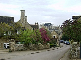
Easton on the Hill is a village and civil parish at the north eastern tip of the district of East Northamptonshire, England. The village is 59 miles east of Birmingham, 79 miles north of London and 12 miles northwest of Peterborough city centre. The population of the civil parish at the 2011 census was 1,015. The village, sited on the A43 road, is compact in form, with the older part of the village located north of the High Street. The parish extends from the River Welland in the north to the western end of RAF Wittering, in the northernmost part of Northamptonshire between Stamford and Collyweston.

Northamptonshire County of England

Northamptonshire, archaically known as the County of Northampton, is a county in the East Midlands of England. In 2015 it had a population of 723,000. The county is administered by Northamptonshire County Council and by seven non-metropolitan district councils. It is known as "The Rose of the Shires".

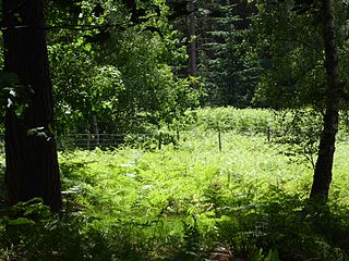
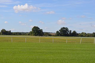
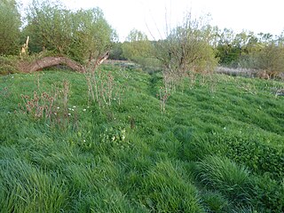
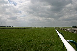
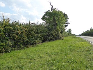
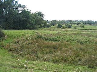
This former quarry is grassland on Jurassic limestone. The flora is diverse, with over thirty flowering plant species in each square metre. There are several locally rare plants, such as dodder, autumn gentian, clustered bellflower and small scabious. The sward is kept short by grazing by sheep and cattle. [3]

The Jurassic period was a geologic period and system that spanned 56 million years from the end of the Triassic Period 201.3 million years ago (Mya) to the beginning of the Cretaceous Period 145 Mya. The Jurassic constitutes the middle period of the Mesozoic Era, also known as the Age of Reptiles. The start of the period was marked by the major Triassic–Jurassic extinction event. Two other extinction events occurred during the period: the Pliensbachian-Toarcian extinction in the Early Jurassic, and the Tithonian event at the end; however, neither event ranks among the "Big Five" mass extinctions.

<i>Cuscuta epithymum</i> species of plant

Cuscuta epithymum is a parasitic plant assigned to the Cuscutaceae or Convolvulaceae family, depending on the taxonomy. It is red-pigmented, not being photosynthetically active. It has a filiform habit, like a group of yarns. Its leaves are very small, like flakes. Its flowers, disposed in little glomerules, have a white corolla, with the androecium welded to the corolla.

The site is private land with no public access.

Related Research Articles

Rex Graham nature reserve

Rex Graham Reserve is a 2.8 hectare biological Site of Special Scientific Interest east of Mildenhall in Suffolk. It is a Special Area of Conservation, and part of the Breckland Special Protection Area. It was formerly managed by the Suffolk Wildlife Trust.

Hankley Farm

Hankley Farm is a 2.4-hectare (5.9-acre) biological Site of Special Scientific Interest (SSSI) west of Elstead in Surrey.

Sheet Hedges Wood

Sheet Hedges Wood is in the parish of Newtown Linford, and lies some 1-mile (1.6 km) north of Groby, in Leicestershire, UK. The site is made up of two areas of woodland and a meadow field, all with public access, extending 29 acres (120,000 m2). The woodland block is adjacent to the road includes a car park and access trails.

Frays Farm Meadows

Frays Farm Meadows is a 28.2-hectare (70-acre) biological Site of Special Scientific Interest near Denham in the London Borough of Hillingdon. It was notified as an SSSI in 1981, and has been managed by the London Wildlife Trust on behalf of Hillingdon Council since 1999. It is part of the Colne Valley Regional Park.

Brampton Racecourse

Brampton Racecourse is a 21.1 hectare biological Site of Special Scientific Interest north of Brampton in Cambridgeshire. The site is also a horse racing venue called Huntingdon Racecourse.

Little Catworth Meadow

Little Catworth Meadow is a 5.2 hectare biological Site of Special Scientific Interest between Catworth and Spaldwick in Cambridgeshire.

Wilbraham Fens

Wilbraham Fens is a 62.5 hectare biological Site of Special Scientific Interest east of Cambridge.

Titchmarsh Meadow

Titchmarsh Meadow is a 2.2 hectare biological Site of Special Scientific Interest north-east of Titchmarsh in Northamptonshire.

Blisworth Rectory Farm Quarry

Blisworth Rectory Farm Quarry is a 1.0 hectare geological Site of Special Scientific Interest west of Blisworth in Northamptonshire. It is a Geological Conservation Review site.

Collyweston Quarries nature reserve in the United Kingdom

Collyweston Quarries is a 6.6 hectare biological Site of Special Scientific Interest in Easton on the Hill in Northamptonshire, south of Stamford. It is managed by the Wildlife Trust for Bedfordshire, Cambridgeshire and Northamptonshire.

Wakerley Spinney

Wakerley Spinney is a 4.4 hectare biological Site of Special Scientific Interest west of King's Cliffe in Northamptonshire.

Hardwick Lodge Meadow

Hardwick Lodge Meadow is a 10 hectare biological Site of Special Scientific Interest north-west of Wellingborough in Northamptonshire.

Southfield Farm Marsh nature reserve in the United Kingdom

Southfield Farm Marsh is an 8.6 hectare biological Site of Special Scientific Interest in Kettering in Northamptonshire. An area of 2.8 hectares is managed as a nature reserve by the Wildlife Trust for Bedfordshire, Cambridgeshire and Northamptonshire.

Crag Farm Pit, Sudbourne

Crag Farm Pit, Sudbourne is a 4.8 hectare geological Site of Special Scientific Interest east of Sudbourne in Suffolk. It is a Geological Conservation Review site, and within the Suffolk Coast and Heaths Area of Outstanding Natural Beauty.

Lordswell Field

Lordswell Field or Lord's Well Field is a 3.2 hectare biological Site of Special Scientific Interest in Eriswell in Suffolk. It is a Nature Conservation Review site, Grade I.

Newmarket Heath

Newmarket Heath is a 279.3 hectare biological Site of Special Scientific Interest in Newmarket in Suffolk. It covers most of Newmarket Racecourse.

Major Farm Meadow

Major Farm Meadow is a 1.8 hectare biological Site of Special Scientific Interest south-west of Eye in Suffolk.

Tolethorpe Road Verges

Tolethorpe Road Verges is a one hectare biological Site of Special Scientific Interest along the verges of Ryall Road between Great Casterton and Ryhall in Rutland.

Great Bowden Borrowpit

Great Bowden Borrowpit is a 2.4 hectare biological Site of Special Scientific Interest north of Market Harborough in Leicestershire.

Frisby Marsh

Frisby Marsh is a 10.2 hectare biological Site of Special Scientific Interest east of Frisby on the Wreake in Leicestershire.

References

  1. 1 2 3 4 "Designated Sites View: Racecourse Farm Fields". Sites of Special Scientific Interest. Natural England. Retrieved 4 April 2017.
  2. "Map of Racecourse Farm Fields". Sites of Special Scientific Interest. Natural England. Retrieved 4 April 2017.
  3. "Racecourse Farm Fields citation" (PDF). Sites of Special Scientific Interest. Natural England. Retrieved 4 April 2017.

Coordinates: 52°37′34″N0°29′53″W / 52.626°N 0.498°W / 52.626; -0.498

Geographic coordinate system Coordinate system

A geographic coordinate system is a coordinate system that enables every location on Earth to be specified by a set of numbers, letters or symbols. The coordinates are often chosen such that one of the numbers represents a vertical position and two or three of the numbers represent a horizontal position; alternatively, a geographic position may be expressed in a combined three-dimensional Cartesian vector. A common choice of coordinates is latitude, longitude and elevation. To specify a location on a plane requires a map projection.