
The Metropolitan Borough of Rotherham is a metropolitan borough of South Yorkshire, England. It is named after its largest town, Rotherham, but also spans the outlying towns of Maltby, Swinton, Wath-upon-Dearne, Dinnington and also the villages of Rawmarsh and Laughton. A large valley also spans the entire borough. Locally known as the Rother Valley.
Whiston is a village and civil parish in the Metropolitan Borough of Rotherham in South Yorkshire, England. It has a population of 5,115, reducing to 5,042 at the 2011 Census.

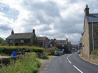
Treeton is a village and civil parish of the Metropolitan Borough of Rotherham in South Yorkshire, England. It is located about 4 miles (6 km) south of the town of Rotherham and 5 miles (8 km) east of Sheffield City Centre.

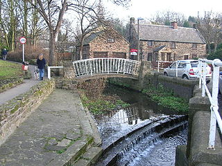
Catcliffe is a village and civil parish on the north-west bank of the River Rother in South Yorkshire, England. The population of the civil parish at the 2011 census was 2,108. It is in the Metropolitan Borough of Rotherham, approximately 2.5 miles (4 km) south of the town of Rotherham and 4.3 miles (7 km) east of Sheffield City Centre.

Broom is a village in South Yorkshire, England and is located in the former parish of Whiston about 1 mile (2 km) southeast of Rotherham. Broom sits on top of a former Roman fortification and was the site of a Saxon trading town. The village currently has a population of 900. The town supports three pubs, a football club, Broom United, and numerous other small businesses.

Strafforth and Tickhill, originally known as Strafforth, was the southernmost wapentake in the West Riding of Yorkshire, England. The west of the district, plus a detached area in the east, constituted the Upper Division, while the central area and a detached part in the extreme east constituted the Lower Division.
William de Lovetot, Lord of Hallamshire, possibly descended from the Norman Baron Ricardus Surdus, was an Anglo-Norman Baron from Huntingdonshire, often credited as the founder of Sheffield, England.
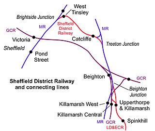
West Tinsley railway station is a former railway station in Sheffield, South Yorkshire, England.
Catcliffe railway station is a former railway station in the Catcliffe area of Rotherham, South Yorkshire, England.
Bolsterstone is a village in South Yorkshire, England, south of Stocksbridge, and 8.5 miles to the northwest of the City of Sheffield and within the city borough. It lies on the border of the Peak District national park. Bolsterstone had a population of 386 in 2011.

Orgreave Colliery was a coal mine situated adjacent to the main line of the Manchester, Sheffield & Lincolnshire Railway about 5 miles (8 km) east of Sheffield and 3.5 miles (6 km) south west of Rotherham. The colliery is within the parish of Orgreave, from which it takes its name.

Woodhouse Mill railway station was opened in 1840 by the North Midland Railway on its line between Rotherham Masborough and Chesterfield.

Treeton railway station is a former railway station in the centre of Treeton, Rotherham, England.
The United Steel Companies was a steelmaking, engineering, coal mining and coal by-product group based in South Yorkshire and Lincolnshire, England.
Treeton Colliery was a coal mine situated in the village of Treeton, near Rotherham, South Yorkshire, England.
Rother Vale Collieries were a group of coal producing pits originally in the Rother Valley parishes of Treeton, Woodhouse and Orgreave, nowadays on the south east Sheffield / Rotherham boundary, in South Yorkshire, England. In the early 20th century a new colliery at Thurcroft was developed.

The A631 is a road running from Sheffield, South Yorkshire to Louth, Lincolnshire in England. It passes through the counties of South Yorkshire, Nottinghamshire and Lincolnshire. The road has many towns on its route including Rotherham, Maltby, Gainsborough and Market Rasen. It is mostly single road throughout its length but has some stretches of dual carriageway as well. The road is approximately 65 miles (105 km) long.

Killamarsh West is a former railway station in Halfway, South Yorkshire, England.

Broomhead Hall was a large English country house that stood in the Ewden valley, to the west of Sheffield, England. The hall stood near the hamlet of Wigtwizzle, to the west of Broomhead Reservoir.

Brampton-en-le-Morthen is a small dormitory village and former civil parish, now in the parish of Thurcroft, in the Rotherham district lying to the south of Rotherham, South Yorkshire, England. In 1911 the parish had a population of 148.

