Gulf Plains Important Bird Area

Last updated
The IBA is an important site for Australian bustards Australian Bustard.jpg
The IBA is an important site for Australian bustards

The Gulf Plains Important Bird Area comprises 8868 km2 of the low-lying coastal plains bordering the south-eastern corner of the Gulf of Carpentaria in north-west Queensland, Australia. It was identified by BirdLife International as an Important Bird Area (IBA) because of its importance to global populations of waders and other birds.

Gulf of Carpentaria A large, shallow sea enclosed on three sides by northern Australia and bounded on the north by the Arafura Sea

The Gulf of Carpentaria is a large, shallow sea enclosed on three sides by northern Australia and bounded on the north by the Arafura Sea. The northern boundary is generally defined as a line from Slade Point, Queensland in the northeast, to Cape Arnhem, Northern Territory in the west.

Queensland North-east state of Australia

Queensland is the second-largest and third-most populous state in the Commonwealth of Australia. Situated in the north-east of the country, it is bordered by the Northern Territory, South Australia and New South Wales to the west, south-west and south respectively. To the east, Queensland is bordered by the Coral Sea and Pacific Ocean. To its north is the Torres Strait, with Papua New Guinea located less than 200 km across it from the mainland. The state is the world's sixth-largest sub-national entity, with an area of 1,852,642 square kilometres (715,309 sq mi).

Australia Country in Oceania

Australia, officially the Commonwealth of Australia, is a sovereign country comprising the mainland of the Australian continent, the island of Tasmania and numerous smaller islands. It is the largest country in Oceania and the world's sixth-largest country by total area. The neighbouring countries are Papua New Guinea, Indonesia and East Timor to the north; the Solomon Islands and Vanuatu to the north-east; and New Zealand to the south-east. The population of 25 million is highly urbanised and heavily concentrated on the eastern seaboard. Australia's capital is Canberra, and its largest city is Sydney. The country's other major metropolitan areas are Melbourne, Brisbane, Perth and Adelaide.

Contents

Description

Most of the region is crown land leased for cattle grazing. There are also permanent fishing camps on the major estuaries. The IBA contains saline mudflats, grasslands, freshwater wetlands and woodlands in an area stretching along the coast from west of Burketown to north of the mouth of the Mitchell River. It is where several river systems – including the Mitchell, Gilbert, Norman, Flinders, Leichhardt and Nicholson Rivers - meet the shallow Gulf of Carpentaria. [1]

Crown land, also known as royal domain or demesne, is a territorial area belonging to the monarch, who personifies the Crown. It is the equivalent of an entailed estate and passes with the monarchy, being inseparable from it. Today, in Commonwealth realms such as Canada and Australia, crown land is considered public land and is apart from the monarch's private estate.

Cattle domesticated form of Aurochs

Cattle—colloquially cows—are the most common type of large domesticated ungulates. They are a prominent modern member of the subfamily Bovinae, are the most widespread species of the genus Bos, and are most commonly classified collectively as Bos taurus.

Grazing method of feeding in which a herbivore eats parts of low-growing grasses, forbs or algae

Grazing is a method of feeding in which a herbivore feeds on plants such as grasses, or other multicellular organisms such as algae. In agriculture, grazing is one method used whereby domestic livestock are used to convert grass and other forage into meat, milk and other products.

During the wet season (December to March) much of the area is flooded when the rivers overflow their banks. The rivers are fringed with paperbark woodlands. The floodplain vegetation consists of grassy eucalypt woodlands as well as open-woodlands dominated by Eucalyptus microtheca . The freshwater grasslands are dominated by species of Dichanthium , while floodplain depressions contain Oryza grasslands that are important for birds. Along the coast, tidal inlets are fringed with mangrove forests, while the salt flats support low shrublands and patchy grasslands. [1]

Wet season yearly period of high rainfall, especially in the tropics

The monsoon season is the time of year when most of a region's average annual rainfall occurs. Generally the season lasts at least a month. The term "green season" is also sometimes used as a euphemism by tourist authorities. Areas with wet seasons are dispersed across portions of the tropics and subtropics.

<i>Melaleuca</i> genus of plants

Melaleuca is a genus of nearly 300 species of plants in the myrtle family, Myrtaceae, commonly known as paperbarks, honey-myrtles or tea-trees. They range in size from small shrubs that rarely grow to more than 1 m high, to trees up to 35 m. Their flowers generally occur in groups, forming a “head” or “spike” resembling a brush used for cleaning bottles, containing up to 80 individual flowers. They are superficially like Banksia species, which also have their flowers in a spike, but the structures of individual flowers in the two genera are very different.

Floodplain Land adjacent to a stream or river which is flooded during periods of high discharge

A floodplain or flood plain is an area of land adjacent to a stream or river which stretches from the banks of its channel to the base of the enclosing valley walls, and which experiences flooding during periods of high discharge. The soils usually consist of levees, silts, and sands deposited during floods. Levees are the heaviest materials and they are deposited first; silts and sands are finer materials.

Birds

The IBA supports large populations of sarus cranes and over 1% of the world populations of brolgas, Australian bustards, black-tailed godwits, great knots, eastern curlews, sharp-tailed sandpipers, lesser sand plovers, grey-tailed tattlers, little curlews, pied oystercatchers, broad-billed sandpipers, red-necked stints and black-winged stilts. [2]

Sarus crane species of bird

The sarus crane is a large non-migratory crane found in parts of the Indian Subcontinent, Southeast Asia and Australia. The tallest of the flying birds, standing at a height of up to 1.8 m, they are a conspicuous species of open wetlands in south Asia, seasonally-flooded Dipterocarp forests in south-east Asia, and Eucalyptus-dominated woodlands and grasslands in Australia.

Brolga species of bird

The brolga, formerly known as the native companion, is a bird in the crane family. It has also been given the name Australian crane, a term coined in 1865 by well-known ornithological artist John Gould in his Birds of Australia.

Australian bustard species of bird

The Australian bustard is a large ground bird inhabiting grassland, woodland and open agricultural country across northern Australia and southern New Guinea. It is also commonly referred to as the plains turkey, and in Central Australia as bush turkey, particularly by Aboriginal people, though this name may also be used for the Australian brushturkey as well as the orange-footed scrubfowl.

Related Research Articles

Macquarie Marshes wetland in Australia

The Macquarie Marshes comprise the wetlands associated with the floodplains of the Macquarie River and its tributaries, in northern New South Wales, Australia. The Macquarie River and the marshes eventually drain into the Darling River. The marshes are important as a breeding site for waterbirds, especially in the aftermath of major floods.

Roebuck Bay Western Australia

Roebuck Bay is a bay on the coast of the Kimberley region of Western Australia. Its entrance is bounded in the north by the town of Broome, and in the south by Bush Point and Sandy Point. It is named after HMS Roebuck, the ship captained by William Dampier when he explored the coast of north-western Australia in 1699. The Broome Bird Observatory lies on the northern coast of the bay.

Lake Macleod lake in Western Australia, Australia

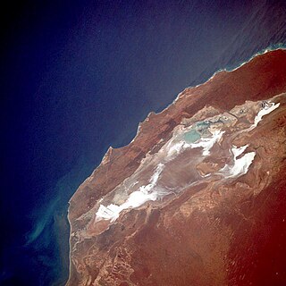
Lake Macleod is the westernmost lake in Australia. The lake lies in the Gascoyne region of Western Australia, north of the small coastal city of Carnarvon.

Eighty Mile Beach beach along the north-west coast of Western Australia about half-way between the towns of Broome and Port Hedland

Eighty Mile Beach, also spelled Eighty-mile Beach or 80-mile Beach, lies along the north-west coast of Western Australia about half-way between the towns of Broome and Port Hedland. It is a beach some 220 kilometres (140 mi) in length, forming the coastline where the Great Sandy Desert approaches the Indian Ocean. It is one of the most important sites for migratory shorebirds, or waders, in Australia, and is recognised as a wetland of international importance under the Ramsar Convention on Wetlands.

Broad Sound (Queensland) sound in Australia

Broad Sound is a large bay on the east coast of Australia, in the state of Queensland 675 km northwest of the state capital, Brisbane. It is about 50 km long and 20 km across at its widest point. The Torilla Peninsula forms the eastern side of the bay; Shoalwater Bay is on the other side of the peninsula.

Gulf Country Region in Queensland, Australia

The Gulf Country is the region of woodland and savanna grassland surrounding the Gulf of Carpentaria in north western Queensland and eastern Northern Territory on the north coast of Australia. The region is also called the Gulf Savannah. It contains large reserves of zinc, lead and silver. The Gulf Country is crossed by the Savannah Way highway.

Pungalina-Seven Emu Sanctuary Protected area in the Northern Territory, Australia

Pungalina-Seven Emu Sanctuary is a 3060 km2 private protected area in the Northern Territory of Australia. It is managed by the Australian Wildlife Conservancy (AWC) which purchased Pungalina Station in 2009, with some assistance from the Wildlife Australia Fund. It adjoins the Gulf of Carpentaria near the border with Queensland, lying in the Gulf Coastal bioregion. The reserve is bordered by Calvert Hills and Wollogorang Stations to the south and east. The nearest town is Borroloola, 150 km to the west.

Ord River Floodplain

The Ord River floodplain is the floodplain of the lower Ord River in the Shire of Wyndham-East Kimberley, in the Kimberley region of northern Western Australia. It lies within the Victoria Bonaparte IBRA bioregion and contains river, seasonal creek, tidal mudflat and floodplain wetlands, with extensive stands of mangroves, that support saltwater crocodiles and many waterbirds. It is recognised as an internationally important wetland area, with 1,384 km2 of it designated on 7 June 1990 as Ramsar Site 477 under the Ramsar Convention on Wetlands.

Adelaide and Mary River Floodplains

The Adelaide and Mary River Floodplains is a 2,687 square kilometres (1,037 sq mi) region comprising the adjoining floodplains of the Adelaide and Mary Rivers of the Top End of Australia’s Northern Territory. It lies east of the city of Darwin and west of Kakadu National Park and the Alligator Rivers IBA, where the rivers flow northwards through seasonally inundated tropical lowlands into the Van Diemen Gulf.

Lake Machattie Area lake in Australia

The Lake Machattie Area is a 909 km2 tract of land comprising Lakes Machattie, Mipia and Koolivoo, with the surrounding Georgina River and Eyre Creek floodplains, in the arid Channel Country of western Queensland, Australia. The area is important as a breeding site for waterbirds.

Lake McLarty

Lake McLarty is a 219-hectare (540-acre) freshwater lake and associated nature reserve on the Swan Coastal Plain of Western Australia. The lake is named after a prominent pioneering family which settled in the district in the early 1860s. It lies about 90 kilometres (56 mi) south of Perth on the eastern side of the Harvey Estuary and forms part of the Peel-Yalgorup System Ramsar site. It is an important area for waders, or shorebirds, and is a well-known birdwatching site.

Legune (Joseph Bonaparte Bay) Important Bird Area Important Bird Area in Northern Territory, Australia

The Legune Important Bird Area comprises a low-lying, swampy, floodplain peninsula at the south-eastern end of the Joseph Bonaparte Gulf in the Top End of the Northern Territory of Australia. The land is part of the Legune Station, a cattle station and pastoral lease.

Limmen Bight bight in Australia

Limmen Bight is a bight, or large, open bay, at the western end of the Gulf of Carpentaria, northern Australia, about 360 km east of the town of Katherine. It is part of the traditional lands and waters of the Marra people. It was named in April 1644 by Abel Tasman for one of his ships on his voyage of exploration along the northern Australian coast. It contains the second largest area of tidal flats in the Northern Territory.

Milingimbi Islands Important Bird Area

The Milingimbi Islands Important Bird Area comprises 94 km2 of land in the Milingimbi, or Crocodile Islands group, of the Northern Territory of Australia. The area is traditionally owned Aboriginal land. The mudflats are an important staging site for migratory waders, or shorebirds.

The Patho Plains Important Bird Area comprises a 794 km2 tract of mainly pastoral farmland near the town of Gunbower in north-central Victoria, south-eastern Australia. It contains several relatively small nature conservation reserves as well as the 38 km2 Terrick Terrick National Park.

Port McArthur Tidal Wetlands System

The Port McArthur Tidal Wetlands System comprises a 994 km2 tract of tidal wetlands on the south-west coast of the Gulf of Carpentaria in the Northern Territory of Australia. The land extends along the coast opposite the Sir Edward Pellew Group of Islands, incorporating the estuaries of the McArthur and Wearyan Rivers. It is an important site for waders, or shorebirds.

Riverland Mallee Important Bird Area

The Riverland Mallee Important Bird Area comprises a 12,200 square kilometres tract of mallee habitat and riverine woodland extending from near Waikerie in the Riverland region in eastern South Australia north-eastwards into south-western New South Wales.

Buckley River Important Bird Area Important Bird Area in Queensland, Australia

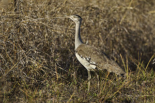
The Buckley River Important Bird Area comprises a 4790 km2 tract of land in the Gulf Country of north-western Queensland, Australia. It lies about 20 km north of the mining city of Mount Isa in the Waggaboonyah Range. It is an important site for Carpentarian grasswrens.

Cadell and Blyth Floodplains

The Cadell and Blyth Floodplains consist of the 432 square kilometres (167 sq mi) floodplain of the lower reaches of the Blyth and Cadell Rivers of northern Arnhem Land in the Top End of the Northern Territory of Australia. It is an important site for waterbirds.

Fog Bay and Finniss River Floodplains

The Fog Bay and Finniss River Floodplains comprise the floodplain of the lower reaches of the Finniss River with the adjoining intertidal mudflats of Fog Bay in the Top End of the Northern Territory of Australia. It is an important site for waterbirds.

References

  1. 1 2 BirdLife International (2011) Important Bird Areas factsheet: Gulf Plains. Downloaded from http://www.birdlife.org on 01/07/2011
  2. "IBA: Gulf Plains". Birdata. Birds Australia. Retrieved 2011-06-29.

Coordinates: 17°01′50″S140°41′37″E / 17.03056°S 140.69361°E / -17.03056; 140.69361

Geographic coordinate system Coordinate system

A geographic coordinate system is a coordinate system that enables every location on Earth to be specified by a set of numbers, letters or symbols. The coordinates are often chosen such that one of the numbers represents a vertical position and two or three of the numbers represent a horizontal position; alternatively, a geographic position may be expressed in a combined three-dimensional Cartesian vector. A common choice of coordinates is latitude, longitude and elevation. To specify a location on a plane requires a map projection.