Gununa is a rural town on Mornington Island within the locality of Wellesley Islands in the Shire of Mornington, Queensland, Australia. [2] In the 2016 census, Gununa had a population of 1,136 people. [1]
Gununa is a rural town on Mornington Island within the locality of Wellesley Islands in the Shire of Mornington, Queensland, Australia. [2] In the 2016 census, Gununa had a population of 1,136 people. [1]
Gununa is located on the southwestern end of Mornington Island, on the Gulf of Carpentaria. The town faces the Appel Channel, ( 16°40′55″S139°11′31″E / 16.682°S 139.192°E ) on the other side of which is Denham Island ( 16°42′52″S139°09′35″E / 16.7144°S 139.1597°E ). [3] [4] [5]
The town was renamed by the Queensland Place Names Board on 16 January 1982. It was formerly known as Mornington Island Community. [2]
Mornington Island State School opened on 28 January 1975. [6]
Gununa Post Office was open by 1982. [7]
In the 2016 census, Gununa had a population of 1,136 people, [1] which is almost all of the 1,143 people who live within the shire as a whole. [8]
Mornington Island State School is a government-run primary and secondary school for boys and girls from early childhood through Year 10. It is located at Lardil Street ( 16°39′59″S139°10′57″E / 16.6663°S 139.1825°E ). [9] [10] In 2018, the school had an enrolment of 263 students, with 25 teachers and 14 part-time and full-time non-teaching staff (the equivalently of 11 full-time employees). [11] It includes a special education program. [9]
There are no schools offering education to Year 12 on the island; nor are there any nearby. [12] Distance education or boarding school are the only options for education past Year 10.
Gununa Post Office is in Mukukiya Street ( 16°39′49″S139°10′38″E / 16.6635°S 139.1771°E ). [13]
Mornington Island Uniting Church is at 21 Dajibuka Street ( 16°39′49″S139°10′36″E / 16.6635°S 139.1766°E ). [14] It is part of the Calvary Presbytery of the Uniting Church in Australia. [15]

Boulia is an outback town and locality in the Shire of Boulia, Queensland, Australia. In the 2016 census, Boulia had a population of 301 people.

Barcaldine is a rural town and locality in the Barcaldine Region in Queensland, Australia. In the 2016 census, Barcaldine had a population of 1,422 people. This is the administrative centre of the Barcaldine Region. Barcaldine played a major role in the Australian labour movement.

Emu Park is a coastal town and locality on the Capricorn Coast located 21 kilometres (13 mi) south of Yeppoon in Queensland, Australia. It is within the local government area of Shire of Livingstone. In the 2016 census the locality of Emu Park had a population of 2,130 people.

Banana is a small town and rural locality in the Shire of Banana, Central Queensland, Australia.

Eidsvold is a rural town and locality in the North Burnett Region, Queensland, Australia. The town is the self-proclaimed Beef Capital of the Burnett and is a hub for the regional cattle industry. In the 2016 census, Eidsvold had a population of 574 people.

Mornington Island, also known as Kunhanhaa, is an island in the Gulf of Carpentaria in the Shire of Mornington, Queensland, Australia. It is the northernmost and largest of 22 islands that form the Wellesley Islands group. The largest town, Gununa, is in the southwestern part of the island. The Manowar and Rocky Islands Important Bird Area lies about 40 kilometres (25 mi) to the northwest of Mornington.

Annerley is a suburb in the City of Brisbane, Queensland, Australia. In the 2016 census, Annerley had a population of 11,336 people.

The Wellesley Islands is a group of islands off the coast of Far North Queensland, Australia, in the Gulf of Carpentaria. It is a locality within the Shire of Mornington local government area. In the 2016 census, the Wellesley Islands had a population of 1,136 people.

Biggenden is a rural town and locality in the North Burnett Region, Queensland, Australia. In the 2016 census, Biggenden had a population of 845 people.

Doomadgee is a town and a locality in the Aboriginal Shire of Doomadgee, Queensland, Australia. It is a mostly Indigenous community, situated about 140 kilometres (87 mi) from the Northern Territory border, and 93 kilometres (58 mi) west of Burketown.

Baralaba is a rural town and locality in the Shire of Banana in central Queensland, Australia. In the 2016 census, Baralaba had a population of 314 people.

Graceville is a suburb in the City of Brisbane, Queensland, Australia. In the 2016 census, Graceville had a population of 4634 people.

Burketown is an isolated outback town and coastal locality in the Shire of Burke, Queensland, Australia. In the 2016 census the locality of Burketown had a population of 238 people.

The Shire of Burke is a local government area in North West Queensland, Australia. The shire lies on the south coast of the Gulf of Carpentaria and abuts the border with the Northern Territory. It covers an area of 39,864 square kilometres (15,391.6 sq mi), and has existed as a local government entity since 1885. The major town and administrative centre of the shire is Burketown. The shire and town are named in honour of ill-fated explorer Robert O'Hara Burke. The Gangalidda name for Burketown is Mungibi meaning ‘little Island’ for the fact that flooding in the wet season often isolates the town.

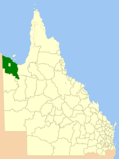
The Shire of Mornington is a local government area in northwestern Queensland, Australia. The shire covers Mornington Island as well as neighbouring islands in the Wellesley Islands group in the Gulf of Carpentaria. Ninety-three percent of the employees of the Shire Council are indigenous local residents.

Mornington Island Airport is an airport on Mornington Island, Queensland, Australia. It is to the immediate north-west of the town of Gununa. In 2006 the airport received $200,853 in funds to improve security.

Crows Nest is a rural town and locality in the Toowoomba Region, Queensland, Australia. The town is located in the Darling Downs on the New England Highway, 158 kilometres (98 mi) from the state capital, Brisbane and 43 kilometres (27 mi) from the nearby city of Toowoomba. In the 2016 census, Crows Nest had a population of 2160 people.

Wowan is a rural town and locality in the Shire of Banana, Queensland, Australia. The town of Deeford is also within the locality. In the 2016 census, the locality of Wowan had a population of 216 people.

Coomera is a town and suburb in the City of Gold Coast, Queensland, Australia. In the 2016 census, Coomera had a population of 13,305 people.

Halifax is a town and a coastal locality in the Shire of Hinchinbrook, Queensland, Australia. In the 2016 census, Halifax had a population of 462 people.