The Gulf of Carpentaria is a large, shallow sea enclosed on three sides by northern Australia and bounded on the north by the eastern Arafura Sea. The northern boundary is generally defined as a line from Slade Point, Queensland in the northeast, to Cape Arnhem on the Gove Peninsula, Northern Territory in the west.

Weipa is a coastal mining town in the local government area of Weipa Town in Queensland. It is the largest town on the Cape York Peninsula. It exists because of the enormous bauxite deposits along the coast. The Port of Weipa is mainly involved in exports of bauxite. There are also shipments of live cattle from the port.

Mornington Island, also known as Kunhanhaa, is an island in the Gulf of Carpentaria in the Shire of Mornington, Queensland, Australia. It is the northernmost and largest of 22 islands that form the Wellesley Islands group. The largest town, Gununa, is in the south-western part of the island.

The Wellesley Islands, also known as the North Wellesley Islands, is a group of islands off the coast of Far North Queensland, Australia, in the Gulf of Carpentaria. It is a locality within the Shire of Mornington local government area. The traditional owners of the islands are the Lardil people. In the 2016 census, the Wellesley Islands had a population of 1,136 people, all living on the largest island, Mornington Island.
Doomadgee is a town and a locality in the Aboriginal Shire of Doomadgee, Queensland, Australia. It is a mostly Indigenous community, situated about 140 kilometres (87 mi) from the Northern Territory border, and 93 kilometres (58 mi) west of Burketown.

Burketown is an isolated outback town and coastal locality in the Shire of Burke, Queensland, Australia. In the 2016 census the locality of Burketown had a population of 238 people.
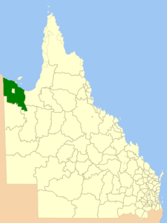
The Shire of Burke is a local government area in North West Queensland, Australia. The shire lies on the south coast of the Gulf of Carpentaria and abuts the border with the Northern Territory. It covers an area of 39,864 square kilometres (15,391.6 sq mi), and has existed as a local government entity since 1885. The major town and administrative centre of the shire is Burketown. The shire and town are named in honour of ill-fated explorer Robert O'Hara Burke. The Gangalidda name for Burketown is Mungibi meaning ‘little Island’ for the fact that flooding in the wet season often isolates the town.
The Shire of Mornington is a local government area in northwestern Queensland, Australia. The shire covers the Wellesley Islands, which includes Mornington Island; the South Wellesley Islands; Bountiful Islands; and West Wellesley / Forsyth Islands groups in the Gulf of Carpentaria.
Kayardild is a moribund Tangkic language spoken by the Kaiadilt on the South Wellesley Islands, north west Queensland, Australia, with fewer than ten fluent speakers remaining. Other members of the family include Yangkaal, Lardil, and Yukulta (Ganggalidda). It is famous for its many unusual case phenomena, including case stacking of up to four levels, the use of clause-level case to signal interclausal relations and pragmatic factors, and another set of 'verbal case' endings which convert their hosts from nouns into verbs morphologically.

The Gulf Country is the region of woodland and savanna grassland surrounding the Gulf of Carpentaria in north western Queensland and eastern Northern Territory on the north coast of Australia. The region is also called the Gulf Savannah. It contains large reserves of zinc, lead and silver. The Gulf Country is crossed by the Savannah Way highway.
Salomon Sweers was a bookkeeper and a counsel for the Dutch East India Company. His younger brother was Admiral Isaac Sweers employed by the Admiralty of Amsterdam.
Gununa, sometimes spelt Gunana, is a rural town on Mornington Island within the locality of Wellesley Islands in the Shire of Mornington, Queensland, Australia. In the 2016 census, Gununa had a population of 1,136 people.

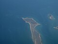
Sweers Island is an island in the South Wellesley Islands in the Gulf of Carpentaria, Queensland, Australia. It is within the Shire of Mornington.
The Lardil people, who prefer to be known as Kunhanaamendaa, are an Aboriginal Australian people and the traditional owners of Mornington Island in the Wellesley Islands chain in the Gulf of Carpentaria, Queensland.
The Kaiadilt are an Aboriginal Australian people of the South Wellesley group in the Gulf of Carpentaria, Queensland, Australia. They are native to Bentinck Island, but also made nomadic fishing and hunting forays to both Sweers and Allen Islands. Most Kaiadilt people now live on Mornington Island, although one group has returned to Bentinck Island.
The West Wellesley Islands, also referred to as the Forsyth Islands, is an island group and locality in the Gulf of Carpentaria within the Shire of Mornington, Queensland, Australia. The group lies to the south-west of the Wellesley Islands, closer to mainland Australia. The islands were uninhabited as of 2016.
Pains Island is one of the West Wellesley Islands, in Queensland's Gulf of Carpentaria, within the Shire of Mornington. It is located 4.83 km northwest of the mainland, and less than a kilometre north of Bayley Island.
Bayley Island is one of the West Wellesley Islands, on the eastern side of the Gulf of Carpentaria, Queensland, within the Shire of Mornington. It is located 2.72 kilometres (1.69 mi) northwest of the mainland, and less than 1 kilometre (0.62 mi) south of Pains Island.
Mirdidingkingathi Juwarnda Sally Gabori was an Aboriginal Australian artist who at age 81 began painting in an abstract-like style she developed to represent her Country, on the south side of Bentinck Island in Queensland, Australia.

Bentinck Island is one of the South Wellesley Islands, in Queensland's Gulf of Carpentaria. The traditional home of the Kaiadilt people, the island was the site of a brutal massacre in 1918 known as the McKenzie massacre, in which many Indigenous inhabitants died.