Greenlee County is a county in the southeastern part of the U.S. state of Arizona. As of the 2020 census, the population was 9,563, making it Arizona's least populous county. The county seat is Clifton.

Clifton is a town in and is the county seat of Greenlee County, Arizona, United States, along the San Francisco River. The population of the town was 3,311 at the 2010 census, with a 2018 population estimate of 3,700. It was a place of the Arizona copper mine strike of 1983.
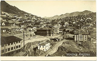
Morenci is a census-designated place (CDP) and company town in Greenlee County, Arizona, United States, and was founded by the Detroit Copper Mining Company of Arizona. The population was 2,000 at the 2000 census and 1,489 at the 2010 census. The biggest employer in Morenci and the owner of the town is Freeport-McMoRan, the owner of the Morenci Mine, the largest copper mining operation in North America, and one of the largest copper mines in the world. The town was a site of the Arizona Copper Mine Strike of 1983. The large open-pit mine is north of the town.

The Apache–Sitgreaves National Forests is a 2.76-million-acre (11,169 km2) United States National Forest which runs along the Mogollon Rim and the White Mountains in east-central Arizona and into the U.S. state of New Mexico. Formerly two forests, it is currently managed as one unit by USDA Forest Service from the Forest Supervisors Office in Springerville, Arizona. Apache–Sitgreaves has over 400 species of wildlife. With its high elevation and cool summer breezes it is a popular weekend destination from the hot desert for Phoenix, Arizona, residents. The forest is divided into 5 Ranger Districts that span almost 300 miles (480 km) from Clifton, Arizona in the east-central portion of Arizona to the eastern boundary of the Coconino National Forest in north-central Arizona. The Apache–Sitgreaves National Forest borders the western and northern borders of the Fort Apache Indian Reservation. It is located in parts of Greenlee, Apache, Navajo, and Coconino counties in eastern and east-central Arizona, and Catron County in western New Mexico. The more northwesterly Sitgreaves National Forest portion lies adjacent to the north side of the Fort Apache Indian Reservation and is located entirely in Arizona, within Navajo, Apache, and Coconino counties. It has a total area of 818,651 acres (3,313 km2). The more southeasterly and much larger Apache National Forest portion lies adjacent to the east side of the Fort Apache and the San Carlos Indian Reservations. It lies on both sides of the border with New Mexico, in Greenlee, Catron, and Apache counties. It has a total area of 1,813,601 acres (7,339 km2).

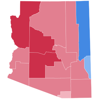
The 1996 United States presidential election in Arizona took place on November 5, 1996, as part of the 1996 United States presidential election. Voters chose eight representatives, or electors to the Electoral College, who voted for president and vice president. Arizona was won by President Bill Clinton (D) over Senator Bob Dole (R-KS), with Clinton winning 46.5% to 44.3% by a margin of 2.2%.

The Black River is a 114-mile-long (183 km) river in the White Mountains of the U.S. state of Arizona. It forms south of the town of Greer and west of the towns of Nutrioso and Alpine. The river flows southwest then northwest to meet the White River west of Fort Apache. The merged streams form the Salt River, a major tributary of the Gila River. Both the Salt and Gila rivers supply water to the Phoenix metro area as well as provides water for farmland and crops around the valley.

Paul Newman is a former member of the Arizona Corporation Commission.

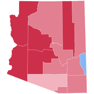
The 2000 United States presidential election in Arizona took place on November 7, 2000, and was part of the 2000 United States presidential election. Voters chose eight representatives, or electors to the Electoral College, who voted for president and vice president.
The Black Hills of Greenlee County are a 20 mi (32 km) long mountain range of the extreme northeast Sonoran Desert bordering the south of the White Mountains of eastern Arizona's transition zone.
Morenci Unified School District is a school district headquartered in Morenci, Arizona, United States.
The 1988 United States presidential election in Arizona took place on November 8, 1988. All fifty states and the District of Columbia, were part of the 1988 United States presidential election. State voters chose seven electors to the Electoral College, which selected the president and vice president.
The 1980 United States presidential election in Arizona took place on November 4, 1980. All fifty states and The District of Columbia were part of the 1980 United States presidential election. State voters chose six electors to the Electoral College, who voted for president and vice president.

Apache Grove is a populated place situated in Greenlee County, Arizona, United States. It has an estimated elevation of 3,550 feet (1,080 m) above sea level. The Apache Creek runs through the town and there is a small bar and convenience store north of the creek.
Whispering Pines is a census-designated place (CDP) in Gila County, Arizona, United States. It is one of two locations in Arizona with this name, the other being a populated place in Greenlee County. The population was 148 at the 2010 United States Census.

The 1972 United States presidential election in Arizona took place on November 7, 1972, as part of the 1972 United States presidential election. State voters chose six representatives, or electors, to the Electoral College, who voted for president and vice president.
Sheldon is a populated place situated in Greenlee County, Arizona, United States, near the border with New Mexico. It is named after Lionel Sheldon, who served as governor of the New Mexico Territory from 1881 to 1885. A post office was opened at this location in 1908, and remained in operation until its closure in 1919.

Arizona's 19th legislative district is one of 30 in the state, consisting of all of Greenlee County and sections of Cochise County, Graham County, Pima County, and Santa Cruz County. As of 2023, there are 96 precincts in the district, with a total registered voter population of 146,048. The district has an overall population of 230,476.


