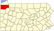
Guys Mills, Pennsylvania | |
---|---|
Coordinates: 41°37′51″N79°58′35″W / 41.63083°N 79.97639°W | |
Country | United States |
State | Pennsylvania |
County | Crawford |
Township | Randolph |
Area | |
• Total | 0.15 sq mi (0.40 km2) |
• Land | 0.15 sq mi (0.40 km2) |
• Water | 0.00 sq mi (0.00 km2) |
Elevation | 1,380 ft (420 m) |
Population | |
• Total | 128 |
• Density | 825.81/sq mi (319.42/km2) |
Time zone | UTC-4 (EST) |
• Summer (DST) | UTC-5 (EDT) |
ZIP code | 16327 |
Area code | 814 |
Guys Mills is a census-designated place in Crawford County, Pennsylvania, United States. The population was 124 at the 2010 census. [3]
Guys Mills is located in northwestern Crawford County at 41°37′51″N79°58′35″W / 41.63083°N 79.97639°W (41.630787, -79.976325), [4] west of the center of Randolph Township. Pennsylvania Route 198 passes through the town, leading northwest 6 miles (10 km) to Blooming Valley and southeast 4 miles (6 km) to Pennsylvania Route 27.
According to the United States Census Bureau, the CDP has a total area of 0.15 square miles (0.40 km2), all land. [3]
Census | Pop. | Note | %± |
---|---|---|---|
2020 | 128 | — | |
U.S. Decennial Census [5] |
As of the census [6] of 2000, there were 133 people, 33 households, and 26 families residing in the CDP. The population density was 858.3 inhabitants per square mile (331.4/km2). There were 34 housing units at an average density of 219.4 per square mile (84.7/km2). The racial makeup of the CDP was 99.25% White and 0.75% Asian. Hispanic or Latino of any race were 2.26% of the population.
There were 33 households, out of which 39.4% had children under the age of 18 living with them, 60.6% were married couples living together, 15.2% had a female householder with no husband present, and 21.2% were non-families. 15.2% of all households were made up of individuals, and 3.0% had someone living alone who was 65 years of age or older. The average household size was 2.85 and the average family size was 3.23.
In the CDP, the population was spread out, with 22.6% under the age of 18, 17.3% from 18 to 24, 31.6% from 25 to 44, 14.3% from 45 to 64, and 14.3% who were 65 years of age or older. The median age was 32 years. For every 100 females, there were 77.3 males. For every 100 females age 18 and over, there were 60.9 males.
The median income for a household in the CDP was $33,125, and the median income for a family was $30,938. Males had a median income of $32,500 versus $21,250 for females. The per capita income for the CDP was $11,978. There were 6.5% of families and 10.9% of the population living below the poverty line, including 17.9% of under eighteens and 12.0% of those over 64.
The John Brown Home, Tannery, & Museum is located in Guys Mills. It was a stop on the Underground Railroad.
Cloverly is an unincorporated town and census-designated place in Montgomery County, Maryland, United States. Its population was 15,285 as of the 2020 census.
Lenape Heights is a census-designated place (CDP) in Armstrong County, Pennsylvania, United States. The population was 1,144 at the 2020 census.
Pine Glen is an unincorporated community and census-designated place (CDP) in Centre County, Pennsylvania, United States. It is part of the State College, Pennsylvania Metropolitan Statistical Area. It is part of Burnside Township. The population was 190 at the 2010 census.
Foundryville is a census-designated place (CDP) in Columbia County, Pennsylvania, United States. It is part of Northeastern Pennsylvania. The population was 256 at the 2010 census. It is part of the Bloomsburg-Berwick micropolitan area.
Jamison City is a census-designated place in Sugarloaf Township, Columbia County, Pennsylvania, United States. It is part of Northeastern Pennsylvania. The population was 134 at the 2010 census. It is part of the Bloomsburg-Berwick micropolitan area.
Rohrsburg is a census-designated place (CDP) in Columbia County, Pennsylvania, United States. It is part of Northeastern Pennsylvania. The population was 145 at the 2010 census. It is part of the Bloomsburg-Berwick micropolitan area.
Canadohta Lake, otherwise known as “Cam-adohta Lake”, is a census-designated place (CDP) in Crawford County, Pennsylvania, United States. The population was 516 at the 2010 census. The current mayor is John Rudolchick.
Geneva is a census-designated place in Crawford County, Pennsylvania, United States. The population was 109 at the 2010 census.
Lincolnville is a census-designated place in Crawford County, Pennsylvania, United States. The population was 96, as per the 2010 census.
Riceville is a census-designated place in Crawford County, Pennsylvania, United States. The population was 68 at the 2010 census.
Oliver is a census-designated place (CDP) in Fayette County, Pennsylvania, United States. The population was 2,535 at the 2010 census, down from 2,925 at the 2000 census. Oliver is located in North Union Township.
Republic is an unincorporated community and census-designated place (CDP) in Fayette County, Pennsylvania, United States. The population was 1,096 at the 2010 census, down from 1,396 at the 2000 census. The community is in Redstone Township.
Jacksonville is a census-designated place (CDP) in Indiana County, Pennsylvania, United States. The population was 637 at the 2010 census. It was formerly an independent borough, until January 1, 1993 when it was returned to Black Lick Township, Pennsylvania.
East Berwick is a census-designated place (CDP) in Salem Township, Luzerne County, Pennsylvania, United States. The population was 2,007 at the 2010 census.
Seneca is a census-designated place (CDP) in Venango County, Pennsylvania, United States. As of the 2000 census, the CDP population was 966.
Woodland Heights is a census-designated place (CDP) in Venango County, Pennsylvania, United States. The population was 1,402 at the 2000 census.
Sheffield is a census-designated place (CDP) within Sheffield Township in southeastern Warren County, Pennsylvania, United States. It is named after Sheffield, England. The population was 1,123 as of the 2010 census.
Warren South is a former census-designated place (CDP) in Warren County, Pennsylvania, United States. The population was 1,651 at the 2000 census.
Socastee is a census-designated place (CDP) in Horry County, South Carolina, United States. The population was 19,952 at the 2010 census.
Chamberlayne is a census-designated place (CDP) in Henrico County, Virginia, United States. The population was 5,581 at the 2020 census.