Halfa, Iowa | |
|---|---|
 Halfa, Iowa | |
| Coordinates: 43°21′07″N94°32′31″W / 43.35194°N 94.54194°W | |
| Country | United States |
| State | Iowa |
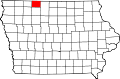
| County | Emmet |
| Elevation | 1,273 ft (388 m) |
| Time zone | UTC-6 (Central (CST)) |
| • Summer (DST) | UTC-5 (CDT) |
| Area code | 712 |
| GNIS feature ID | 457204 [1] |
Halfa is an unincorporated community in Emmet County, Iowa, United States. [1]