
Glasgow is a home rule-class city in Barren County, Kentucky, United States. It is the seat of its county. Glasgow is the principal city of the Glasgow micropolitan area, which comprises Barren and Metcalfe counties. The population was 15,014 at the 2020 U.S. census.

Ashland is a home rule-class city in Boyd County, Kentucky, United States. The largest city in Boyd County, Ashland is located upon a southern bank of the Ohio River at the state border with Ohio and near West Virginia. The population was 21,625 at the 2020 census. Ashland is a principal city of the Huntington–Ashland metropolitan area, referred to locally as the "Tri-State area", home to 376,155 residents as of 2020. Ashland serves as an important economic and medical center for northeastern Kentucky.

Jackson is a home rule-class city in and the county seat of Breathitt County, Kentucky, in the United States. The population was 2,231 according to the 2010 U.S. census.
Hopkinsville is a home rule-class city in and the county seat of Christian County, Kentucky, United States. The population at the 2020 census was 31,180.
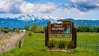
Halfway is a city in Baker County, Oregon, United States. The city took its name from the location of its post office, on the Alexander Stalker ranch, halfway between Pine and Jim Town. The population was 351 at the 2020 census.
Corbin is a home rule-class city in Whitley, Knox and Laurel counties in the southeastern portion of the U.S. state of Kentucky. As of the 2020 census, the city population was 7,856.
Romance is an unincorporated community in west-central White County, Arkansas, United States. The community is located approximately halfway between the town of Rose Bud to the north, and the unincorporated community of El Paso to the south. Alternately, the community is about 16 miles (26 km) northwest of Beebe, and less than 5 miles (8 km) east of Mount Vernon.
Royalton is an unincorporated community in Magoffin County, Kentucky, United States. It lies along Route 7 southeast of the city of Salyersville, the county seat of Magoffin County. Its elevation is 879 feet (268 m). Although it is unincorporated it had a post office, with the ZIP code 41464.

Elizaville is a census-designated place and unincorporated community in Fleming County, Kentucky, United States. Its population was 181 as of the 2010 census. Elizaville is located at the junction of Kentucky Route 32 and Kentucky Route 170, 5 miles (8.0 km) west of Flemingsburg. Elizaville has a post office with ZIP code 41037.
McDaniels is an unincorporated community in Breckinridge County, Kentucky, United States. McDaniels is located along Kentucky Route 259, 15.5 miles (24.9 km) due south of Hardinsburg. McDaniels is situated on Rough River Lake, which collects the 29.5-mile-long (47.5 km) North Fork Rough River, which flows for its entire length in Breckinridge County. McDaniels has a post office with ZIP code 40152.

Marshall is an unincorporated community in Spokane County, Washington, United States. Named in 1880 for early settler William H. Marshall, Marshall has a post office with ZIP code 99020.
Garfield is an unincorporated community in Breckinridge County, Kentucky, United States.

Golden Pond was a town in western Trigg County, Kentucky, United States. It is now the site of the headquarters of Land Between the Lakes National Recreation Area, 11 miles (18 km) west-southwest of Cadiz. Golden Pond was established in the 19th century and became known for its moonshining activity during the Prohibition era. This town was in an area altered during the 1930s and later by the Tennessee Valley Authority, which constructed dams to control flooding and generate electricity for a large rural area. The TVA evicted the last residents of Golden Pond in 1969, when the recreation area was established.
Powersville is an unincorporated community located in Bracken County, Kentucky, United States.
Belcher is an unincorporated community in Pike County, Kentucky. Belcher is located at the junction of U.S. Route 460 and Kentucky Route 80 2.9 miles (4.7 km) north-northwest of Elkhorn City. Belcher has a post office with ZIP code 41513.

Belfry is an unincorporated community and census-designated place in Pike County, Kentucky. Belfry is located on U.S. Route 119, 16.8 miles (27.0 km) northeast of Pikeville. Belfry has a post office with ZIP code 41514, which opened on February 26, 1921. The origin of the name "Belfry" is obscure.
Harned is an unincorporated community in Breckinridge County, Kentucky, United States. Harned is located on U.S. Route 60, 3.2 miles (5.1 km) southeast of Hardinsburg. Harned has a post office with ZIP code 40144.
Almo is an unincorporated community in Calloway County, Kentucky, United States. No one knows when the community was founded, but a rail center was established in the early 1890s by the Nashville, Chattanooga & St. Louis Railway. A post office was opened on February 11, 1891, and given the name Buena, Kentucky. The name of the post office was changed to Almo on November 18, 1892. The new name may have been a shortening of the name Alamo from the Texas Revolution. The post office closed on August 15, 2022.
New Concord is an unincorporated community in Calloway County, Kentucky, United States.
Reedyville is an Unincorporated community in Butler County, Kentucky, United States. The town is supposedly named for the nearby Big Reedy Creek, a tributary of the Green River.


