The Arabian Sea is a region of the northern Indian Ocean bounded on the north by Pakistan, Iran and the Gulf of Oman, on the west by the Gulf of Aden, Guardafui Channel and the Arabian Peninsula, on the southeast by the Laccadive Sea and the Maldives, on the southwest by Somalia, and on the east by India. Its total area is 3,862,000 km2 (1,491,000 sq mi) and its maximum depth is 4,652 meters (15,262 ft). The Gulf of Aden in the west connects the Arabian Sea to the Red Sea through the strait of Bab-el-Mandeb, and the Gulf of Oman is in the northwest, connecting it to the Persian Gulf.
The Coral Sea Islands Territory is an external territory of Australia which comprises a group of small and mostly uninhabited tropical islands and reefs in the Coral Sea, northeast of Queensland, Australia. The only inhabited island is Willis Island. The territory covers 780,000 km2 (301,160 sq mi), most of which is ocean, extending east and south from the outer edge of the Great Barrier Reef and includes Heralds Beacon Island, Osprey Reef, the Willis Group and fifteen other reef/island groups. Cato Island is the highest point in the Territory.

India is situated north of the equator between 8°4' north to 37°6' north latitude and 68°7' east to 97°25' east longitude. It is the seventh-largest country in the world, with a total area of 3,287,263 square kilometres (1,269,219 sq mi). India measures 3,214 km (1,997 mi) from north to south and 2,933 km (1,822 mi) from east to west. It has a land frontier of 15,200 km (9,445 mi) and a coastline of 7,516.6 km (4,671 mi).
Mayotte is an overseas department and region and single territorial collectivity of France officially named the Department of Mayotte. It is located in the northern part of the Mozambique Channel in the Indian Ocean off the coast of Southeastern Africa, between Northwestern Madagascar and Northeastern Mozambique. Mayotte consists of a main island, Grande-Terre, a smaller island, Petite-Terre, as well as several islets around these two. Mayotte is the most prosperous territory in the Mozambique Channel, making it a major destination for illegal immigration.

Madeira, officially the Autonomous Region of Madeira, is one of the two autonomous regions of Portugal, the other being the Azores. It is an archipelago situated in the North Atlantic Ocean, in a region known as Macaronesia, just under 400 kilometres (250 mi) to the north of the Canary Islands and 520 kilometres (320 mi) west of Morocco. Madeira is geologically located on the African Tectonic Plate, though the archipelago is culturally, economically and politically European. Its total population was estimated in 2021 at 251,060. The capital of Madeira is Funchal, which is located on the main island's south coast.

The Pacific Ocean is the largest and deepest of Earth's five oceanic divisions. It extends from the Arctic Ocean in the north to the Southern Ocean in the south, and is bounded by the continents of Asia and Australia in the west and the Americas in the east.

The Andaman and Nicobar Islands is a union territory of India consisting of 572 islands, of which 37 are inhabited, at the junction of the Bay of Bengal and the Andaman Sea. The territory is about 150 km (93 mi) north of Aceh in Indonesia and separated from Thailand and Myanmar by the Andaman Sea. It comprises two island groups, the Andaman Islands (partly) and the Nicobar Islands, separated by the 150 km wide Ten Degree Channel, with the Andaman islands to the north of this latitude, and the Nicobar islands to the south. The Andaman Sea lies to the east and the Bay of Bengal to the west. The island chains are thought to be a submerged extension of the Arakan Mountains.

Sakha, officially the Republic of Sakha (Yakutia), is a republic of Russia, in the Russian Far East, along the Arctic Ocean, with a population of roughly 1 million. Sakha comprises half of the area of its governing Far Eastern Federal District, and is the world's largest country subdivision, covering over 3,083,523 square kilometers. Yakutsk, which is the world's coldest major city, is its capital and largest city. The republic has a reputation for an extreme and severe climate, with the lowest temperatures in the Northern Hemisphere being recorded in Verkhoyansk and Oymyakon, and regular winter averages commonly dipping below −35 °C (−31 °F) in Yakutsk. The hypercontinental tendencies also result in warm summers for much of the republic.

Honshu, historically called Hondo, is the largest and most populous main island of Japan. It is located south of Hokkaidō across the Tsugaru Strait, north of Shikoku across the Inland Sea, and northeast of Kyūshū across the Kanmon Straits. The island separates the Sea of Japan, which lies to its north and west, from the North Pacific Ocean to the south and east. It is the seventh-largest island in the world, and the second-most populous after the Indonesian island of Java.
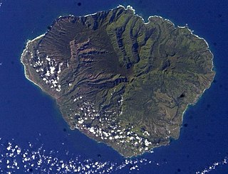
Kauaʻi, anglicized as Kauai, is geologically the second-oldest of the main Hawaiian Islands. With an area of 562.3 square miles (1,456.4 km2), it is the fourth-largest of these islands and the 21st largest island in the United States. Known also as the "Garden Isle", Kauaʻi lies 73 miles (117 km) across the Kauaʻi Channel, northwest of Oʻahu. This island is the site of Waimea Canyon State Park and the Na Pali Coast State Park.

Hawaii is the largest island in the United States, located in the state of Hawaii. It is the southeasternmost of the Hawaiian Islands, a chain of volcanic islands in the North Pacific Ocean. With an area of 4,028 square miles (10,430 km2), it has 63% of the Hawaiian archipelago's combined landmass. However, it has only 13% of Hawaiʻi's population. The island of Hawaiʻi is the third largest island in Polynesia, behind the two main islands of New Zealand.

The contiguous United States or officially the conterminous United States, also known as the Lower 48, consists of the 48 adjoining U.S. states and the District of Columbia on the continent of North America. The terms exclude the non-contiguous states of Alaska and Hawaii and all other offshore insular areas, such as American Samoa, Guam, the Northern Mariana Islands, Puerto Rico, and the U.S. Virgin Islands. These differ from the related term continental United States, which includes Alaska but excludes the Hawaiian Islands and all U.S. territories in the Caribbean and the Pacific.

Guadalcanal is the principal island in Guadalcanal Province of Solomon Islands, located in the south-western Pacific, northeast of Australia. It is the largest island in the Solomon Islands by area, and the second by population. The island is mainly covered in dense tropical rainforest and has a mountainous hinterland.

The Hawaiian Islands are an archipelago of eight major islands, several atolls, and numerous smaller islets in the North Pacific Ocean, extending some 1,500 miles from the island of Hawaiʻi in the south to northernmost Kure Atoll. Formerly the group was known to Europeans and Americans as the Sandwich Islands, a name that James Cook chose in honor of the 4th Earl of Sandwich, the then First Lord of the Admiralty. Cook came across the islands by chance when crossing the Pacific Ocean on his Third Voyage, on board HMS Resolution; he was later killed on the islands on a return visit. The contemporary name of the islands, dating from the 1840s, is derived from the name of the largest island, Hawaiʻi Island.
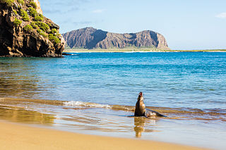
The Galápagos Islands, part of the Republic of Ecuador, are an archipelago of volcanic islands. They are distributed on either side of the equator in the Pacific Ocean, surrounding the centre of the Western Hemisphere. Located 906 km (563 mi) west of continental Ecuador, the islands are known for their large number of endemic species that were studied by Charles Darwin during the second voyage of HMS Beagle. His observations and collections contributed to the inception of Darwin's theory of evolution by means of natural selection.

An exclusive economic zone (EEZ), as prescribed by the 1982 United Nations Convention on the Law of the Sea, is an area of the sea in which a sovereign state has special rights regarding the exploration and use of marine resources, including energy production from water and wind. It stretches from the outer limit of the territorial sea out to 200 nautical miles (nmi) from the coast of the state in question. It is also referred to as a maritime continental margin and, in colloquial usage, may include the continental shelf. The term does not include either the territorial sea or the continental shelf beyond the 200 nautical mile limit. The difference between the territorial sea and the exclusive economic zone is that the first confers full sovereignty over the waters, whereas the second is merely a "sovereign right" which refers to the coastal state's rights below the surface of the sea. The surface waters, as can be seen in the map, are international waters.

The 2004 Indian Ocean earthquake and tsunami occurred at 07:58:53 local time (UTC+7) on 26 December, with an epicentre off the west coast of northern Sumatra, Indonesia. It was an undersea megathrust earthquake that registered a magnitude of 9.1–9.3 , reaching a Mercalli intensity up to IX in certain areas. The earthquake was caused by a rupture along the fault between the Burma Plate and the Indian Plate.

Greece is a country of the Balkans, in Southeastern Europe, bordered to the north by Albania, North Macedonia and Bulgaria; to the east by Turkey, and is surrounded to the east by the Aegean Sea, to the south by the Cretan and the Libyan Seas, and to the west by the Ionian Sea which separates Greece from Italy.