Related Research Articles

Hamersley is a residential suburb 14 kilometres north-northwest of the central business district of Perth, the capital of Western Australia, and six kilometres (4 mi) from the Indian Ocean. The suburb adjoins two major arterial roads—Mitchell Freeway to the west and Reid Highway to the south—and is within the City of Stirling local government area. It was built during the late 1960s and 1970s as part of the Government of Western Australia's response to rapidly increasing land prices across the metropolitan area.

The City of Wanneroo is a local government area with city status in the northern suburbs of Perth, Western Australia. It is centred approximately 25 kilometres (15.5 mi) north of Perth's central business district and forms part of the northern boundary of the Perth metropolitan area. Wanneroo encompasses the federal divisions of Cowan, Moore and Pearce.

Forrestfield is a suburb of the City of Kalamunda in Western Australia. It lies 15 kilometres to the south-east of Perth at the base of the Darling Scarp and the southern border of Perth Airport.
The Mitchell Freeway is a 41.5-kilometre-long (25.8 mi) freeway in the northern suburbs of Perth, Western Australia, linking central Perth with the city of Joondalup. It is the northern section of State Route 2, which continues south as Kwinana Freeway and Forrest Highway. Along its length are interchanges with several major roads, including the Graham Farmer Freeway and Reid Highway. The southern terminus of the Mitchell Freeway is at the Narrows Bridge, which crosses the Swan River, and the northern terminus is at Romeo Road in Alkimos.

Watermans Bay is a northern coastal suburb of Perth, the capital city of Western Australia. Its local government area is the City of Stirling.

Alkimos is a coastal suburb of Perth, Western Australia, located 42 kilometres (26 mi) north-northwest of Perth's central business district. It is part of the City of Wanneroo local government area.

Butler is an outer suburb of Perth, Western Australia, 41 kilometres north of Perth's central business district. It is part of the City of Wanneroo local government area. It forms the majority of the Brighton Estate, a large commercial and residential development by Satterley.

Eglinton is a locality in the Western Australian capital city of Perth, approximately 44 kilometres (27 mi) north of Perth's central business district on the Indian Ocean. For the most part, the suburb is covered in native banksia woodland, scrubland and heath typical of the Swan Coastal Plain. However, in recent years, there has been growth in residential estates, with a town centre to be built in the near future.
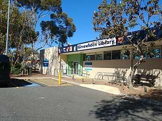
Girrawheen is a northern suburb of Perth, the capital city of Western Australia. Its local government area is the City of Wanneroo.

Jindalee is an outer coastal suburb of Perth, Western Australia, located approximately 40 kilometres (25 mi) north of the Perth central business district. Its local government area is the City of Wanneroo.
Madeley is a suburb of Perth, the capital city of Western Australia 20 kilometres (12 mi) north of Perth's central business district. Its local government area is the City of Wanneroo. Previously part of Landsdale, much of the suburb was rural in character until the 1990s, with market gardening a common activity. From 2001 onwards, extensive property development resulted in massive population growth, with the Property Investor Magazine of December 2007 estimating a growth rate of 33.3% per year.
Heathridge is a suburb of Perth, Western Australia, located 33 kilometres (21 mi) south of Yanchep within the City of Joondalup.
Hillarys is a northern coastal suburb of Perth, the capital city of Western Australia, in the local government area of the City of Joondalup. It is part of the Whitfords precinct, and is located 21 km north-northwest of Perth's central business district via Mitchell Freeway and Hepburn Avenue.

Great Eastern Highway Bypass is a limited-access dual carriageway linking Great Eastern Highway and Roe Highway in Perth, Western Australia. Together with a section of Roe Highway, it bypasses the historical Guildford and Midland localities, through which the original, urban and slower Great Eastern Highway passes.

Cullacabardee is a northeastern rural suburb of Perth, the capital city of Western Australia, located 21 km (13 mi) from Perth's central business district via Alexander Drive or Beechboro Road. It is in the City of Swan local government area. Most of the suburb is covered in native sheoak and banksia forest. A small Noongar community is based on Baal Street, a drug rehabilitation retreat is located off Gnangara Road in the suburb's northeast, and the Perth International Telecommunications Centre facility is based in the suburb's northwest.
Beach Road is a major east–west road in the northern suburbs of Perth, Western Australia, connecting Perth's inner northern beachside suburbs and inland state housing areas with shopping and public transport facilities at Warwick and the Malaga industrial area. It was mostly built between 1967 and 1974, and is a dual carriageway for most of its length, except for a small western part between Marmion Avenue and the coast, which is a minor residential distributor road and is discontinuous at Marmion Avenue. Beach Road also serves as a local government boundary. From Alexander Drive to Wanneroo Road, Beach Road is the boundary with the City of Wanneroo on the northern side and the City of Stirling on the southern side. From Wanneroo Road to the coast Beach Road is the boundary with the City of Joondalup on the northern side and the City of Stirling on the southern side.
Warwick Road is an arterial east-west road located in the northern suburbs of Perth, Western Australia. It was built in 1969 to service the Shire of Wanneroo parts of the Hamersley Development Scheme, which was later split into the suburbs of Duncraig, Warwick and Greenwood. Its original alignment, which was gazetted in 1949 as Road No. 10578 by the Wanneroo Road Board, was a straight east-west road extending to Alexander Drive, but in the mid-1970s, the alignment was altered southwards in the vicinity of the freeway alignment, and in the late 1970s, the section east of Wanneroo Road was split off to form Marangaroo Drive.
Gordon Stephenson was a British-born town planner and architect. He is best known for his role in shaping the modern growth and development of Perth, Western Australia.
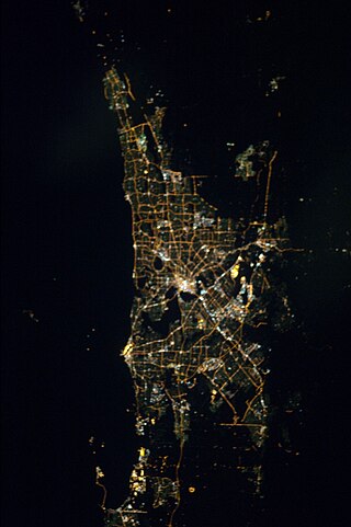
The Perth metropolitan region or the Perth metropolitan area is the administrative area and geographical extent of the Western Australian capital city of Perth and its conurbation.
Ocean Reef Marina is a development project in Ocean Reef, Western Australia to construct a new marina with commercial and residential areas at the existing Ocean Reef Boat Harbour. The site is being developed by DevelopmentWA; construction of its two breakwaters started in April 2021, with the whole project expected to be fully completed in 2036 and then becoming part of the City of Joondalup. The concept for a marina by developers in the area of Mullaloo and Ocean Reef had been proposed as far back as 1973.
References
- ↑ Legislative Council of Western Australia (13 August 1968). "Land in Hamersley Area - Release". Hansard. p. 288.
* Carr, Dr. David (14 November 1967). "Hamersley - Rezoning from Urban Deferred to Urban (Report No. Hous/55)". Minutes of the Metropolitan Region Planning Authority (July–December 1967).
* "Government To Free 1,000 Acres for Houses near City". The West Australian . 14 December 1967. p. 2. - ↑ Western Australia - Committee on the Taxation of Unimproved Land and on Land Prices (January 1968). Report - Land taxation and land prices in Western Australia. Part I (Report to Premier Brand). Chapters 3, 4 and 5.
- ↑ Carr, Dr. David (14 November 1967). "Hamersley - Rezoning from Urban Deferred to Urban (Report No. Hous/55)". Minutes of the Metropolitan Region Planning Authority (July–December 1967). Accessed at State Records Office, Perth.
- ↑ "Meeting Minutes - Metropolitan Region Planning Authority". Minutes of the Metropolitan Region Planning Authority (July–December 1967). 13 December 1967. p. 84.7.
- ↑ "Government To Free 1,000 Acres for Houses near City". The West Australian . 14 December 1967. p. 2.
- ↑ "Advertisement of Resolution Deciding to Prepare a Town Planning Scheme. Town Planning Scheme 26 – Hamersley Development Scheme (TPB 853/2/20/26)". Western Australia Government Gazette. 26 January 1968. pp. 1968:172.
- ↑ Hewison, Kevin (K.J.) (Shire Planner) (29 February 1968). "Hamersley Development Scheme - A few background and explanatory notes". Shire of Perth - Town Planning Committee Minute Book (2574/26). p. 346. Attached to Item No.6, 5 March 1968. Accessed at State Records Office, Perth.
- ↑ "Discourtesy Alleged By Perth Shire". The West Australian (North Suburban Section). 17 July 1968. p. 3.
- ↑ Jones, Adrienne (17 April 1968). "Hamersley Scheme - Shire Agrees to First Subdivision". The West Australian (North Suburban Section). p. 1. Accessed at Battye Library, Perth.
- ↑ "Government Warns Buyers of Land - Be Cautious". The West Australian. 14 December 1968. p. 1.
- ↑ "Sale Prices Drop After Warning By Brand". The West Australian. 16 December 1968. p. 2.
* "Hamersley blocks go at one-a-minute - Average of $4,784 at R&I land auction". Sunday Times . 15 December 1968. p. 2.
* "Editorial - Drop In Land Prices". The West Australian. 17 December 1968. p. 6.