
White County is a county located in the U.S. state of Arkansas. As of the 2020 census, the population was 76,822. The county seat is Searcy. White County is Arkansas's 31st county, formed on October 23, 1835, from portions of Independence, Jackson, and Pulaski counties and named for Hugh Lawson White, a Whig candidate for President of the United States. It is an alcohol prohibition or dry county, though a few private establishments can serve alcohol.

Pulaski County is a county in the U.S. state of Arkansas. With a population of 399,125 as of the 2020 United States Census, it is the most populous county in Arkansas. The county is included in the Little Rock–North Little Rock–Conway metropolitan area. Its county seat is Little Rock, which is also Arkansas's capital and largest city.

Lonoke County is located in the Central Arkansas region of the U.S. state of Arkansas. As of the 2020 census, the population was 74,015, making it the 10th-most populous of Arkansas's 75 counties. The county seat is Lonoke and largest city is Cabot. Lonoke County was formed on April 16, 1873, from Pulaski County and Prairie County, and was named as a corruption of "lone oak", after a large red oak in the area that had been used by a surveyor to lay out the Memphis and Little Rock Railroad.

Jefferson County, Arkansas is a county located in the U.S. state of Arkansas in the area known as the Arkansas Delta that extends west of the Mississippi River. Jefferson County consists of five cities, two towns, and 20 townships. The county is bisected by the Arkansas River, which was critical to its development and long the chief transportation byway. In 2020, Jefferson County's population was estimated at 67,260. Its county seat and largest city is Pine Bluff. Jefferson County is included in the Pine Bluff metropolitan statistical area. The county seat and the most populous city is Pine Bluff.
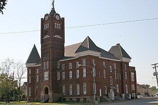
Jackson County is located in the Arkansas Delta in the U.S. state of Arkansas. The county is named for Andrew Jackson, a national hero during the War of 1812. By the county's formation in 1829, Jackson had become the seventh President of the United States. Jackson County is home to seven incorporated towns and four incorporated cities, including Newport, the largest city and county seat. The county is also the site of numerous unincorporated communities and ghost towns. Occupying 633.94 square miles (164,190 ha), Jackson County is the 41st largest county of the 75 in Arkansas. As of the 2020 Census, the county's population was 16,755. Based on population, the county is the 44th-largest county in Arkansas. Although terrain rises in the west, most of Jackson County is within the Arkansas Delta, characterized by largely flat terrain with fertile soils. Historically covered in forest, bayous and swamps, the area was cleared for agriculture by early settlers. It is drained by the White River.
Izard County is a county located in the U.S. state of Arkansas. As of the 2020 census, the population was 13,577. The county seat is Melbourne. Izard County is Arkansas's 13th county, formed on October 27, 1825, and named for War of 1812 General and Arkansas Territorial Governor George Izard. It is an alcohol prohibition or dry county.
Independence County is a county located in the U.S. state of Arkansas. As of the 2020 census, the population was 37,938. The county seat is Batesville. Independence County is Arkansas's ninth county, formed on October 20, 1820, from a portion of Lawrence County and named in commemoration of the Declaration of Independence. It is an alcohol prohibition or dry county.
Faulkner County is located in the Central Arkansas region of the U.S. state of Arkansas. As of the 2020 census, the population was 123,498, making it the fifth most populous of Arkansas's 75 counties. The county seat and largest city is Conway. Faulkner County was created on April 12, 1873, one of nine counties formed during Reconstruction, and is named for Sandford C. Faulkner, better known as Sandy Faulkner, a popular figure in the state at the time.

Dallas County is a county located in the U.S. state of Arkansas. As of the 2020 census, the population was 6,482, making it the fourth-least populous county in Arkansas. The county seat is Fordyce. Dallas County is Arkansas's 49th county, formed on January 1, 1845; it was named for George M. Dallas, 11th Vice President of the United States.
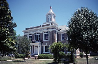
Cleveland County is a county located in the U.S. state of Arkansas. Its population was 7,550 at the 2020 U.S. census. The county seat and largest city is Rison.

Cleburne County is a county located in the U.S. state of Arkansas. As of the 2020 census, the population was 24,711. The county seat and most populous city is Heber Springs. The county was formed on February 20, 1883, as the last of Arkansas's 75 counties to be formed. It is named for Confederate Major-General Patrick Cleburne. Cleburne is an alcohol prohibition or dry county.

Austin is a city in Lonoke County, Arkansas, United States. The population was 2,038 as of the 2010 census and an estimated 3,693 as of 2018. It is part of the Little Rock–North Little Rock–Conway Metropolitan Statistical Area.

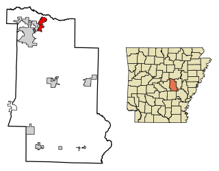
Carlisle is a city in Lonoke County, Arkansas, United States. It is the easternmost municipality within the Little Rock–North Little Rock–Conway Metropolitan Statistical Area. Carlisle was incorporated in 1878. As of the 2010 census it had a population of 2,214.
Coy is a town in southern Lonoke County, Arkansas, United States. The population was 96 at the 2010 census, making it the smallest incorporated community within the Little Rock–North Little Rock–Conway Metropolitan Statistical Area, as well as one of the smallest in the state.

Humnoke is a city in Lonoke County, Arkansas, United States. The population was 284 at the 2010 census. It is part of the Little Rock–North Little Rock–Conway Metropolitan Statistical Area.

Keo is a town in southwest Lonoke County, Arkansas, United States. The population was 256 at the 2010 census. It is part of the Little Rock–North Little Rock–Conway Metropolitan Statistical Area.

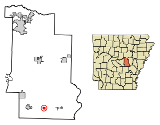
Lonoke is the second most populous city in Lonoke County, Arkansas, United States, and serves as its county seat. According to 2010 United States Census, the population of the city is 4,245. It is part of the Little Rock–North Little Rock–Conway Metropolitan Statistical Area.
Ward is the third most populous city in Lonoke County, Arkansas, United States. The population was 4,067 at the 2010 census. It is part of the Little Rock–North Little Rock–Conway Metropolitan Statistical Area.

Brush Creek Township is one of 37 townships in Washington County, Arkansas, USA. As of the 2010 census, its unincorporated population was 2,877.


