
Fort Worth is a city in the U.S. state of Texas and the seat of Tarrant County, covering nearly 350 square miles (910 km2) into Denton, Johnson, Parker, and Wise counties. According to the 2024 United States census estimate, Fort Worth's population was 996,756 making it the fourth-most populous city in the state and the 12th-most populous in the United States. Fort Worth is the second-largest city in the Dallas–Fort Worth metroplex, which is the fourth-most populous metropolitan area in the United States and the most populous in Texas.

Tarrant County is a county located in the U.S. state of Texas with a 2020 U.S. census population of 2,110,640, making it the third-most populous county in Texas and the 15th-most populous in the United States. Its seat of government is Fort Worth. Tarrant County, one of 26 counties created out of the Peters Colony, was established in 1849 and organized the next year. It is named after Edward H. Tarrant, a lawyer, politician, and militia leader.

Hornell is a city in Steuben County, New York, United States. The population was 8,259 at the 2020 census. The city is named after the Hornell family, early settlers.

Ardmore is the county seat of Carter County, Oklahoma, United States. The population was 24,725 at the time of the 2020 census, a 1.8% increase over the 2010 census figure of 24,283. The Ardmore micropolitan statistical area had an estimated population of 48,491 in 2013. Ardmore is 90 miles (140 km) from both Oklahoma City and Dallas/Fort Worth, Texas, at the junction of Interstate 35 and U.S. Highway 70, and is generally considered the hub of the 13-county region of South Central Oklahoma, also known by state tourism pamphlets as "Chickasaw Country" and previously "Lake and Trail Country". It is also a part of the Texoma region. Ardmore is situated about 9 miles (14 km) south of the Arbuckle Mountains and is located at the eastern margin of the Healdton Basin, one of the most oil-rich regions of the United States.

Lancaster is a town in Erie County, New York, United States, centered 14 miles east of downtown Buffalo. Lancaster is an outer ring suburb of Buffalo. As of the 2020 Census, the town population was 45,106.

Texas and Pacific Station, commonly known as T&P Station, is a terminal Trinity Railway Express and TEXRail commuter railroad station is located at 1600 Throckmorton Street in Fort Worth, Texas, on the south side of downtown. It is the current western terminus of the TRE commuter line, and is located near the Fort Worth Convention Center, the Fort Worth Water Gardens, Sundance Square and Tarrant County government facilities. T&P Station features free parking which can be accessed from West Vickery Boulevard.

The Como neighborhood is a historically African-American neighborhood located on the west side of Fort Worth, Texas. Como was named after Como, Italy. One of its residents was a neighborhood activist Viola Pitts. The Como Lake was built in 1889. Originally the neighborhood was conceived as a resort. In the early 1900s Lillian Russell visited the resort and was impressed by it. The neighborhood newspaper, the Lake Como Weekly, was published under several titles between 1940 and 1986.

The Northern Texas Traction Company was a subsidiary of Stone & Webster that operated the streetcar system and interurban lines in Fort Worth, Texas.
The Indiana Railroad (IR) was the last of the typical Midwestern United States interurban lines. It was formed in 1930–31 by combining the operations of the five major interurban systems in central Indiana into one entity. The predecessor companies came under the control of Midland Utilities, owned by Samuel Insull. His plan was to modernize the profitable routes and abandon the unprofitable ones. With the onset of the Great Depression, the Insull empire collapsed and the Indiana Railroad was left with a decaying infrastructure and little hope of overcoming the growing competition of the automobile for passenger business and the truck for freight business. The IR faced bankruptcy in 1933, and Bowman Elder was designated as the receiver to run the company. Payments on bonded debt were suspended. Elder was able to keep the system virtually intact for four years, and IR operated about 600 miles (970 km) of interurban lines throughout Indiana during this period. During the late 1930s, the routes were abandoned one by one until a 1941 wreck with fatalities south of Indianapolis put an abrupt end to the Indiana Railroad's last passenger operations.
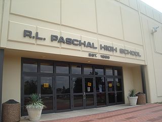
R. L. Paschal High School is a secondary school in Fort Worth, Texas, United States. It is part of the Fort Worth Independent School District, and is the oldest and largest high school in Fort Worth ISD.

The International Railway Company (IRC) was a transportation company formed in a 1902 merger between several Buffalo-area interurban and street railways. The city railways that merged were the West Side Street Railway, the Crosstown Street Railway and the Buffalo Traction Company. The suburban railroads that merged included the Buffalo & Niagara Electric Street Railway, and its subsidiary the Buffalo, Lockport & Olcott Beach Railway; the Buffalo, Depew & Lancaster Railway; and the Niagara Falls Park & River Railway. Later the IRC acquired the Niagara Gorge Railroad (NGRR) as a subsidiary, which was sold in 1924 to the Niagara Falls Power Company. The NGRR also leased the Lewiston & Youngstown Frontier Railroad.
The London and Lake Erie Railway and Transportation Company is a defunct Interurban railway that operated in Ontario, Canada from 1902 to 1918. Originally chartered as the South Western Traction Company, the line was renamed the London and Lake Erie Railway in 1909. Throughout its short life, the line was always referred to locally as "The Traction Line".
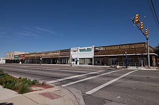
The Central Handley Historic District is located in Handley, Fort Worth, Texas, seven miles east of downtown. The district was the commercial center of the unincorporated small town of Handley which was subsequently annexed into the city of Fort Worth, Texas in 1946.

Arlington Heights is a neighborhood in Fort Worth, Texas.
Village Creek is a tributary creek of the West Fork of the Trinity river in Tarrant and Johnson county, Texas, USA. It is the main inflow of Lake Arlington. It is approximately 23 miles (37 km) long. Its watershed is approximately 143 square miles (370 km2).

The Lake Erie and Northern Railway was an interurban electric railway which operated in the Grand River Valley in Ontario, Canada. The railway owned and operated a north–south mainline which ran from Galt in the north to Port Dover on the shore of Lake Erie in the south. Along the way, it ran through rural areas of Waterloo County, Brant County, and Norfolk County, as well as the city of Brantford, where it had an interchange with the Brantford and Hamilton Electric Railway. Construction on the mainline began in 1913. The railway began operations in 1916 as a subsidiary of the Canadian Pacific Railway (CPR), which had purchased the line before construction had finished. In 1931, it was consolidated with the Grand River Railway under a single CPR subsidiary, the Canadian Pacific Electric Lines (CPEL), which managed both interurban railways, though they continued to exist as legally separate entities. Passenger service was discontinued in 1955 but electric freight operations continued until 1961, when the LE&N's electric locomotives were replaced by diesel CPR locomotives and the line was de-electrified. In the same year, service on the mainline from Simcoe to Port Dover was discontinued, but the remainder continued to operate as a branchline which as early as 1975 was known as the CP Simcoe Subdivision. The remainder of the line was officially abandoned in the early 1990s, ending almost seventy-five years of operation.

