
Tornado, also called Upper Falls, is a census-designated place (CDP) in Kanawha County, West Virginia, United States.

Brethren is an unincorporated community and census-designated place (CDP) in the U.S. state of Michigan. The community is located within Dickson Township, Manistee County, and is in the Northern Lower Peninsula of Michigan. The community had a population of 331 at the 2020 census, down from 410 in 2010. The community is located in the Manistee National Forest, 18 miles (29 km) northeast of Manistee. Brethren has a post office with ZIP code 49619.

Briceville is an unincorporated community in Anderson County, Tennessee. It is included in the Knoxville, Tennessee Metropolitan Statistical Area. The community is named for railroad tycoon and one-term Democratic U.S. Senator Calvin S. Brice of Ohio, who was instrumental in bringing railroad service to the town.
Jodie, also known as Imboden, is an unincorporated community in Fayette County, West Virginia, United States. It is located along the Gauley River at the mouth of Rich Creek, 4 miles (6.4 km) northeast of Gauley Bridge. Due to its proximity to the county line, Jodie is part of the Nicholas County ZIP code of 26690; it had its own post office until its closure on July 23, 2005.

Coulter is an unincorporated community and census-designated place in South Versailles Township, Allegheny County, Pennsylvania, United States. The community is located along the Youghiogheny River, 14.3 miles (23.0 km) southeast of Pittsburgh.
Hatchechubbee is an unincorporated community in Russell County, Alabama, United States. Hatchechubbee is located at the junction of Alabama State Route 26 and County Route 65, 6.5 miles (10.5 km) west-southwest of Seale. Hatchechubbee has a post office with ZIP code 36858, which opened on August 17, 1855. The community's name is derived from the Creek words hachi meaning "creek" and chaba meaning "halfway".
Mexia is an unincorporated community in Monroe County, Alabama, United States. Mexia is located on Alabama State Route 47, 4 miles (6.4 km) west-southwest of Monroeville. Mexia has a post office with ZIP code 36458. Mexia has two small historic cemeteries on Thompson Road and Rolland Road. The largest church in Mexia is Mexia Baptist Church located on Old Salem Road. In Mexia there is also New Chapel Baptist Church located on Snowden Road, and Old Salem Baptist Church located on Old Salem Creek Road.
Laurel Fork is an unincorporated community in Carroll County, Virginia. It is located off U.S. Route 58 and is 12.4 miles (20.0 km) east-southeast of Hillsville, Virginia. Laurel Fork has a post office with the ZIP code 24352.
McQuady is an unincorporated community in Breckinridge County, Kentucky, United States. McQuady is located at the junction of Kentucky Route 105 and Kentucky Route 261, 5.9 miles (9.5 km) south-southwest of Hardinsburg. McQuady has a post office with ZIP code 40153.
Glen Dean is an unincorporated community in Breckinridge County, Kentucky, United States. Glen Dean is located at the west end of Kentucky Route 108, 9.8 miles (15.8 km) south-southwest of Hardinsburg. Glen Dean had a post office until it closed on June 22, 1991.
Stephensport is an unincorporated community in Breckinridge County, Kentucky, United States.
Culberson is an unincorporated community in Cherokee County, North Carolina, United States. Culberson is located on North Carolina Highway 60 near the Georgia state line, 10 miles (16 km) southwest of Murphy. Culberson has a post office with ZIP code 28903. Culberson is also home to a store, a few churches, a flea market, a local winery, several family-owned businesses, and a gas station on the NC/GA state line.
Muscadine is an unincorporated community in Cleburne County, Alabama, United States. It is near the Alabama-Georgia state line. Muscadine is 2.75 miles (4.43 km) east of Fruithurst. Muscadine has a post office with ZIP code 36269, a general store, and a bar.

Fort Davis is an unincorporated community in Macon County, Alabama, United States, located on U.S. Route 29, 12.9 miles (20.8 km) south of Tuskegee. Fort Davis has a post office with ZIP code 36031, which opened on June 4, 1891.

La Madera is a census-designated place in Rio Arriba County, New Mexico, United States. Its population was 154 as of the 2010 census. La Madera has a post office with ZIP Code 87539.
Plainfield is an unincorporated community in Dodge County, Georgia, United States. The community is located near Georgia State Route 117, 7.4 miles (11.9 km) northeast of Eastman.
Warthen is an unincorporated community and census-designated place (CDP) in Washington County, Georgia, United States. The community is located at the junction of Georgia State Route 15 and Georgia State Route 102, 8.3 miles (13.4 km) north of Sandersville. Warthen has a post office with ZIP code 31094.

Barney is an unincorporated community in Brooks County, Georgia, in the United States. The community is located at the junction of state routes 76 and 122, 4.6 miles (7.4 km) north of Morven. Barney has a post office with ZIP code 31625.
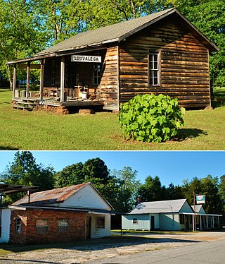
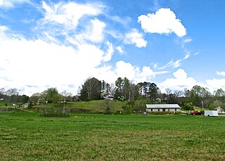
Louvale is an unincorporated community in Stewart County, Georgia, United States. The community is located along U.S. Route 27, 8.7 miles (14.0 km) north of Lumpkin. Louvale has a post office with ZIP code 31814.
Bangall is a hamlet in Dutchess County, New York, United States. The community is 6.2 miles (10.0 km) north of Millbrook. Bangall has a post office with ZIP code 12506, which opened on August 8, 1851.


