
The tuatara is a species of reptile endemic to New Zealand. Despite its close resemblance to lizards, it is part of a distinct lineage, the order Rhynchocephalia. The name tuatara is derived from the Māori language and means "peaks on the back".

Moa are an extinct group of flightless birds formerly endemic to New Zealand. During the Late Pleistocene-Holocene, there were nine species. The two largest species, Dinornis robustus and Dinornis novaezelandiae, reached about 3.6 metres (12 ft) in height with neck outstretched, and weighed about 230 kilograms (510 lb) while the smallest, the bush moa, was around the size of a turkey. Estimates of the moa population when Polynesians settled New Zealand circa 1300 vary between 58,000 and approximately 2.5 million.

Macquarie Island is an island in the southwestern Pacific Ocean, about halfway between New Zealand and Antarctica. Regionally part of Oceania and politically a part of Tasmania, Australia, since 1900, it became a Tasmanian State Reserve in 1978 and was inscribed as a UNESCO World Heritage Site in 1997.
The Poor Knights Islands are a group of islands off the east coast of the Northland Region of the North Island of New Zealand. They lie 50 kilometres (31 mi) to the northeast of Whangārei, and 22 kilometres (14 mi) offshore halfway between Bream Head and Cape Brett. Uninhabited since the 1820s, they are a nature reserve and popular underwater diving spot, with boat tours typically departing from Tutukaka. The Poor Knights Islands Marine Reserve surrounds the island.

Cape Palliser is a promontory on the southern coast of New Zealand's North Island and is the southernmost point of the North Island; it is in fact considerably farther south than Nelson or Blenheim in the South Island.

Rotokura / Cable Bay is a bay and small settlement 18 kilometres (11 mi) north-east of Nelson in New Zealand. The settlement at the head of the bay is at the southern end of a thin strip of land or causeway connecting Pepin Island with the South Island.

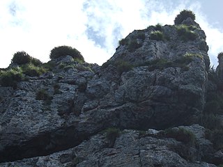
The Boulder Bank is a very unusual naturally formed landform in Nelson, New Zealand. It is a 13 kilometre long stretch of rocky substrate which begins at the Mackay Bluff and ends at the Cut of the Nelson Harbour. Haulashore Island was once a part of the Boulder Bank, but the Cut made it an island, and it is no longer connected to the Boulder Bank. The Boulder Bank separates Tasman Bay and the Nelson Haven and is managed as a scenic reserve by the Department of Conservation. Land access is gained along Boulder Bank Drive, signposted at the northern end of Nelson Haven on State Highway 6.
The Open Bay Islands are located in South Westland, off the south-west coast of the South Island of New Zealand. They consist of two main islands, Taumaka and Popotai, plus several smaller islets and rocks. They lie approximately 5 km (3.1 mi) offshore from the Okuru River mouth, near Haast, and are owned by the West Coast branch Māori iwi Ngāi Tahu known as Poutini Ngāi Tahu.
The Roding River is a river of the Tasman Region of New Zealand's South Island. It flows generally southwest from its sources in the hills above the city of Nelson, reaching the Wairoa River five kilometres south of Richmond. The rock type Rodingite is named after the Roding River. The catchment has numerous mine sites and shafts which attempted to make the copper and chromite deposits in the Dun Mountain Ophiolite Belt profitable in the late 19th century.

Pepin Island is a privately owned tied island in New Zealand connected by a causeway to the settlement of Cable Bay, north-east of Nelson.

Fairfield House in 48 Van Diemen Street, Nelson, New Zealand, is registered with Heritage New Zealand as a Category I structure. Originally built in 1849, today's house was constructed as a residence for Arthur Atkinson in 1872. It was at some stage owned by the Nelson College for Girls, who used it as a boarding house. After the 1929 Murchison earthquake, boarders from Nelson College also moved in, as their hostel got damaged. The house was given to Nelson City Council in 1979 and was threatened with demolition. A community group formed that had the objective of saving the house. Alan Stanton moved into the derelict building as a squatter and started restoring it. Today, it is a community centre.
Arrow Rock is a small island in Tasman Bay / Te Tai-o-Aorere, off the coast of Nelson, New Zealand. There is a narrow channel between the rock and Haulashore Island. Situated within Nelson Harbour, Arrow Rock was site of the Fifeshire wreck in 1842, which gave the rock its secondary name. There are a number of spotted shags who live on the rock.

Tonga Island is a small (0.15 km2) island in Tasman Bay / Te Tai-o-Aorere, off the northern coast of the South Island of New Zealand. It lies within the Abel Tasman National Park, about 1 kilometre (0.62 mi) off Onetahuti Beach. The island has a flourishing fur seal colony, and is surrounded by the Tonga Island Marine Reserve, which was inaugurated in 1993.

Stepneyville is a suburb of Nelson, New Zealand.
Annesbrook is an industrial suburb of Nelson, New Zealand.

Waimea Inlet is a section of Tasman Bay / Te Tai-o-Aorere, in New Zealand's South Island. It is at the southern end of the bay, and separated from it by the partial barriers of Rabbit Island and Bell Island to the west and Monaco Peninsula and the reclaimed land of Nelson Airport to the east. The southern suburbs of Stoke and the town of Richmond lie close to the shore of Waimea Inlet.
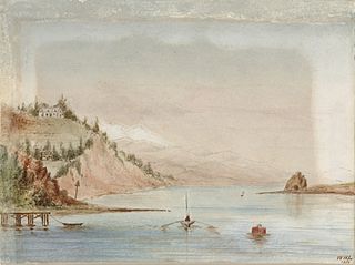
Delaware Bay is an indentation in the New Zealand South Island coast east of Pepin Island, to the north of Nelson. It is part of the larger Tasman Bay / Te Tai-o-Aorere. The bay is named after the Delaware, a newly built brig which sank here on its maiden voyage from Nelson to Napier in 1863, an incident best remembered for the dramatic rescue attempts by a group of local Māori.

Wendy Alison Nelson is a New Zealand marine scientist and world expert in phycology. She is New Zealand's leading authority on seaweeds. Nelson is particularly interested in the biosystematics of seaweeds/macroalgae of New Zealand, with research on floristics, evolution and phylogeny, as well as ecology, and life history studies of marine algae. Recently she has worked on the systematics and biology of red algae including coralline algae, distribution and diversity of seaweeds in harbours and soft sediment habitats, and seaweeds of the Ross Sea and Balleny Islands.

This is a list of the units into which the rock succession of New Zealand is formally divided. As new geological relationships have been discovered new names have been proposed and others are made obsolete. Not all these changes have been universally adopted. This table is based on the 2014 New Zealand Stratigraphic Lexicon (Litho2014). However, obsolete names that are still in use and names postdating the lexicon are included if it aids in understanding.
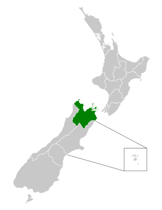
The Nelson Marlborough District Health Board was a district health board with the focus on providing healthcare to the Nelson, Tasman and Marlborough districts of New Zealand. In July 2022, it was merged into the national health service Te Whatu Ora.
