This article needs additional citations for verification .(December 2021) |
Herleshausen | |
---|---|
Location of Herleshausen within Werra-Meißner-Kreis district ![]() | |
Coordinates: 51°01′N10°10′E / 51.017°N 10.167°E Coordinates: 51°01′N10°10′E / 51.017°N 10.167°E | |
Country | Germany |
State | Hesse |
Admin. region | Kassel |
District | Werra-Meißner-Kreis |
Subdivisions | 11 districts |
Government | |
• Mayor (2018–24) | Lars Böckmann [1] |
Area | |
• Total | 59.52 km2 (22.98 sq mi) |
Elevation | 363 m (1,191 ft) |
Population (2020-12-31) [2] | |
• Total | 2,766 |
• Density | 46/km2 (120/sq mi) |
Time zone | UTC+01:00 (CET) |
• Summer (DST) | UTC+02:00 (CEST) |
Postal codes | 37293 |
Dialling codes | 05654 |
Vehicle registration | ESW |
Website | www.herleshausen.de |
Herleshausen is a municipality in the Werra-Meißner-Kreis in Hesse, Germany.
Herleshausen lies north of a section of the boundary with Thuringia in the thickly wooded area between the Ringgau and the Thuringian Forest (ranges) with the Thuringian Forest Nature Park in the southeast. It is found between the river Werra in the south and the Autobahn A 4 (Aachen–Görlitz) in the north.
Herleshausen borders on the municipal area of the district-free town of Eisenach, whose main centre lies some 12 km east-southeast. To the district seat of Eschwege to the north-northwest, it is about 22 km, and to Kassel, the nearest city, to the northwest, it is about 60 km (each time as the crow flies).
Herleshausen borders in the north on the communities of Ringgau (Werra-Meißner-Kreis) and Ifta (Wartburgkreis in Thuringia), in the east on the town of Creuzburg and the community of Krauthausen (both in the Wartburgkreis), in the southeast on the Thuringian district-free town of Eisenach, in the south on the community of Gerstungen (Wartburgkreis) and in the west on the town of Sontra (Werra-Meißner-Kreis).
The community's eleven Ortsteile are Herleshausen, Wommen, Nesselröden, Breitzbach, Unhausen, Holzhausen, Markershausen, Altefeld, Archfeld, Willershausen and Frauenborn.
In 1019, Herleshausen had its first documentary mention in a donation document in which ownership was transferred to the Kaufungen Abbey, which then held the village until Secularization in 1521. Thereafter, it passed to the Landgraves of Hesse-Kassel, who enfeoffed various lords with it.
The community found itself on a much more public stage after the Second World War when a border checkpoint between East and West Germany was built near Herleshausen. Many prisoner exchanges between the two German states took place during the Cold War at the border checkpoint, including German soldiers returning from Soviet captivity and East German citizens traded to West Germany in return for hard currency and goods.
![]() | This section needs to be updated.(July 2021) |
The municipal election held on 26 March 2006 yielded the following results:
Parties and voter communities | % 2006 | Seats 2006 | % 2001 | Seats 2001 | |
CDU | Christian Democratic Union of Germany | 32.4 | 6 | 30.7 | 6 |
SPD | Social Democratic Party of Germany | 49.1 | 9 | 53.3 | 10 |
WSRG | Wählergemeinschaft Südringgau | 18.5 | 4 | 16.0 | 3 |
Total | 100.0 | 19 | 100.0 | 19 | |
Voter turnout in % | 65.0 | 66.9 |
The community's arms might be described thus: Gules a wall embattled with two end towers with pointed roofs argent and with closed gate Or, above which a tower with a double cupola of the second.
The crenellated wall stands for the fortress church estate, which has the parish church's quire tower rising above it. The tinctures red and silver are Hesse's state colours. The coat of arms was approved in 1954 by the Hesse Interior Ministry.
After the Reformation was introduced and Hesse's monasteries were secularized, Philip I, Landgrave of Hesse enfeoffed with the Herleshausen estate his troop leader Georg von Reckerode, who built himself the "Steinstock" palace there in 1539. After Reckerode's death in 1558, he was followed as fiefholder by the family von Wersebe, who enlarged the complex by building two wings onto it. When the Wersebes' male line died out in 1678, the palace and the Herleshausen estate passed back to Charles I, Landgrave of Hesse-Kassel, who transferred it to his brother Philipp, first as a fief, and later to have as his own. Thereafter, the palace and the Herleshausen estate were held by the family Hesse-Philippsthal-Barchfeld. In 1821, the palace was given the name "Augustenau", after Landgrave Charles's recently deceased consort Auguste von Hohenlohe-Ingelfingen.
Herleshausen has a railway station on the Thüringer Bahn railway between Eisenach and Bebra. Here, the last prisoners of war were released after Konrad Adenauer's visit to Moscow in 1955.
Running by the community is a section of the Autobahn A 4 (Aachen–Görlitz) with its Herleshausen interchange. The Herleshausen service centre was torn down in 2005 to make way for the 6-lane expansion. There are, however, new plans to build another service centre, "Werratal", on the A 4's south side.
Eisenach is a town in Thuringia, Germany with 42,000 inhabitants, located 50 kilometres west of Erfurt, 70 km southeast of Kassel and 150 km northeast of Frankfurt. It is the main urban centre of western Thuringia and bordering northeastern Hessian regions, situated near the former Inner German border. A major attraction is Wartburg castle, which has been a UNESCO World Heritage Site since 1999.
Werra-Meißner is a Kreis (district) in the north of Hesse, Germany. Neighboring districts are Göttingen, Eichsfeld, Unstrut-Hainich-Kreis, Wartburgkreis, district-free Eisenach, Hersfeld-Rotenburg, Schwalm-Eder-Kreis, Kassel.
Wartburgkreis is a Kreis (district) in the west of Thuringia, Germany. Neighboring districts are the districts Unstrut-Hainich-Kreis, Gotha, Schmalkalden-Meiningen, and the districts Fulda, Hersfeld-Rotenburg and Werra-Meißner-Kreis in Hesse.
Eschwege, the district seat of the Werra-Meißner-Kreis, is a town in northeastern Hesse, Germany. In 1971, the town hosted the eleventh Hessentag state festival.
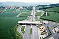
Bundesautobahn 4 is an autobahn that crosses Germany in a west–east direction. The western segment has a length of 156 km (97 mi), the part in the east is 429 km (267 mi) long. Works to continue the A 4 are in progress, but currently no plans exist to fill the gap completely.
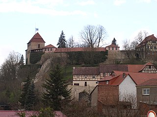
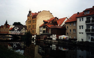
Creuzburg is a town and a former municipality on the Werra river in the Wartburgkreis in Thuringia, Germany. Since December 2019, it is part of the town Amt Creuzburg.
Sontra is a small town in the Werra-Meißner-Kreis in northeastern Hesse, Germany.
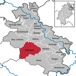
Waldkappel is a small town in the Werra-Meißner-Kreis district in northern Hesse, Germany.
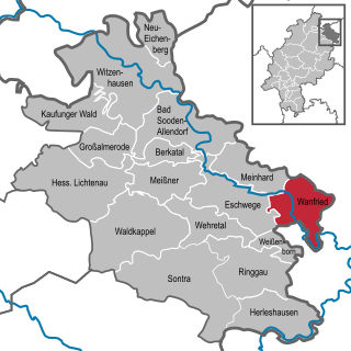
Wanfried is a town in the Werra-Meißner-Kreis in northeasternmost Hesse, Germany. It is classified as a Landstadt, a designation given in Germany to a municipality that is officially a town (Stadt), but whose population is below 5,000. It literally means “country town”.
Philippsthal (Werra) is a market community in Hersfeld-Rotenburg district in eastern Hesse, Germany, right at the boundary with Thuringia.
Meißner is a municipality in the Werra-Meißner-Kreis in Hesse, Germany.
Ringgau is a municipality in the Werra-Meißner-Kreis in Hesse, Germany.
Wehretal is a municipality in the Werra-Meißner-Kreis in northeastern Hesse, Germany.
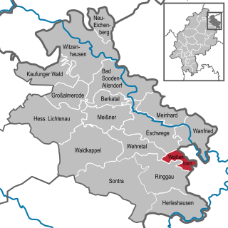
Weißenborn is a municipality in the Werra-Meißner-Kreis in Hesse, Germany.
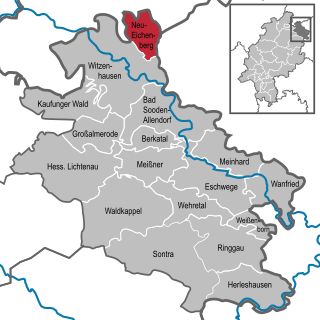
Neu-Eichenberg is a municipality in the Werra-Meißner-Kreis in Hesse, Germany.
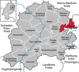
Wildeck is a community in Hersfeld-Rotenburg district in northeastern Hesse, Germany lying right at the boundary with Thuringia, 54 km southeast of Kassel.
The Halle–Bebra railway, known in German as the Thüringer Bahn, is a 210 kilometre-long railway line from Halle (Saale) via Erfurt and Gerstungen to Bebra, mainly in Thuringia. As far as Gerstungen the line originally belonged to the Thuringian Railway Company. From Gerstungen to Bebra, it was owned by the Frederick William Northern Railway (Friedrich-Wilhelms-Nordbahn), named after the Prussian king, Frederick William IV. It is now a two-track, electrified, standard gauge mainline operated by DB Netze. It was opened between 1846 and 1849 and was the first railway line in Thuringia. All types of trains from Regionalbahn to ICE currently run on the line except Interregio-Express. Four of the six largest cities in Thuringia are located on the line.
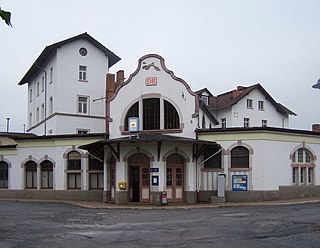
Gerstungen station is located in the town of Gerstungen on the western border of the German state of Thuringia on the Halle–Bebra railway. The station has been particularly notable for its history as a border station between different states and railway administrations.
The Seulingswald is a hill range in the German Central Uplands which reaches heights of up to 480.3 m above sea level (NHN). It is part of the Fulda-Werra Uplands in the East Hesse Highlands within the Hessian county of Hersfeld-Rotenburg; small ridges extend into the Thuringian county of Wartburgkreis. It is a sandstone range and one of the largest contiguous woodland areas in Hesse.