Heron Dam

Last updated
Heron Dam
HeronLakeNM.jpg
The Brazos Cliffs, Heron Lake, and the north wall of the Rio Chama Gorge, looking east.
USA New Mexico relief location map.svg
Red pog.svg
Location of Heron Dam in New Mexico
CountryUnited States
Location Rio Arriba County, New Mexico
Coordinates 36°39′57″N106°42′22″W / 36.665915°N 106.706226°W / 36.665915; -106.706226
PurposeIrrigation
Opening date1971
Owner(s) United States Bureau of Reclamation
Dam and spillways
Type of dam Storage dam
Height263 feet (80 m)
Length1,250 feet (380 m)
Reservoir
Total capacity401,000 acre-feet (495,000,000 m3)

Heron Dam is a storage dam Rio Arriba County, in northern New Mexico in the southwestern United States, just north of the El Vado Dam. It is owned and operated by the United States Bureau of Reclamation. [1] The dam is about 9 miles west of the town of Tierra Amarilla. [2]

Contents

Construction

The dam was built as part of the San Juan–Chama Project, which transfers water from the San Juan River basin through the 12.8 miles (20.6 km) Azotea Tunnel under the Continental Divide into Willow Creek, where it is stored in Heron Reservoir as part of the Colorado River Storage Project. The dam is located on Willow Creek near the creek's confluence with the Rio Chama. [1] Construction was completed in 1971. [3] The outlet works at El Vado Dam, just downstream from Heron Dam, were enlarged as part of the San Juan-Chama Project so releases from Heron Reservoir could pass unimpeded through the dam. The capacity of the El Vado outlet works was increased to pass 6,600 cubic feet (190 m3) per second. [4]

Structure

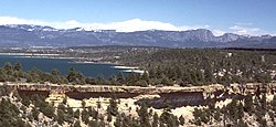
The reservoir lies at an elevation of 7,192 feet (2,192 m) above sea level. The earthfill dam is 1,221 feet (372 m) long and 276 feet (84 m) high. [3] Heron Dike, one mile northwest of the dam, helps contain the reservoir. It has a concrete crest spillway with an open chute with a discharge capacity of 600 cubic feet (17 m3) per second. The dam's outlet works include an intake structure, 10 feet (3.0 m) diameter concrete-lined upstream tunnel, gate chamber, 11 feet (3.4 m) modified horseshoe concrete-lined downstream tunnel, and a stilling basin. The discharge capacity is 4,160 cubic feet (118 m3) per second at a reservoir elevation of 7,190.8 feet (2,191.8 m). [5]

When filled, the reservoir covers 5,905 acres (23.90 km2). [6] The maximum safe storage capacity is 401,000 acre-feet (495,000,000 m3). Downstream channel capacity is about 6,000 cubic feet (170 m3) per second. [1]

Operations

The dam was built strictly for storage and delivery of San Juan-Chama Project water for municipal, domestic, industrial, recreation, irrigation, and fish and wildlife purposes. The water is diverted to New Mexico as agreed under the Colorado River and Upper Colorado River Compacts. The amount of water diverted each year, and the way in which it is used, are subject to well-defined agreements. [1] Flows of "native" or "natural" water from Willow Creek and from the Rio Chama upstream of the dam are measured and bypassed through the reservoir. [7]

The dam provides up to 5,000 acre-feet (6,200,000 m3) of San Juan-Chama water annually to maintain the recreation pool at Cochiti Reservoir. The dam can supply about 96,200 acre-feet (118,700,000 m3) of San Juan-Chama water annually to users with reasonable certainty. [1] There is no carry-over provision: contractors must take delivery of their water by December 31. This means that contractors such as the City of Albuquerque or the Middle Rio Grande Conservancy District often withdraw their water and arrange to store it in downstream reservoirs such as El Vado, Abiquiu, Jemez Canyon (by exchange), and Elephant Butte. [7]

Related Research Articles

<span class="mw-page-title-main">Rio Grande</span> Major river forming part of the US–Mexico border

The Rio Grande in the United States or the Río Bravo in Mexico is one of the principal rivers in the southwestern United States and in northern Mexico. The length of the Rio Grande is 1,896 miles (3,051 km), making it the 4th longest river in North America by main stem. It originates in south-central Colorado, in the United States, and flows to the Gulf of Mexico. The Rio Grande drainage basin (watershed) has an area of 182,200 square miles (472,000 km2); however, the endorheic basins that are adjacent to and within the greater drainage basin of the Rio Grande increase the total drainage-basin area to 336,000 square miles (870,000 km2).

McGee Creek Reservoir is a reservoir in Atoka County, Oklahoma. It impounds the waters of McGee Creek and several smaller streams, including Potapo, Panther, Little Bugaboo, Bear, Blue, Mill, and Crooked creeks, all of which are tributaries of Muddy Boggy River. According to the Bureau of Reclamation (BuRec), the reservoir was designed to extend 14 miles (23 km) up McGee Creek and 9 miles (14 km) up Potapo Creek when the water is at "conservation level.

<span class="mw-page-title-main">Colorado–Big Thompson Project</span> Federal water diversion project

The Colorado–Big Thompson Project is a federal water diversion project in Colorado designed to collect West Slope mountain water from the headwaters of the Colorado River and divert it to Colorado's Front Range and plains. In Colorado, approximately 80% of the state's precipitation falls on the West Slope, in the Rocky Mountains, while around 80% of the state's growing population lives along the eastern slope, between the cities of Fort Collins and Pueblo.

<span class="mw-page-title-main">Rio Chama</span> River of Colorado and New Mexico in the US

The Rio Chama, a major tributary river of the Rio Grande, is located in the U.S. states of Colorado and New Mexico. The river is about 130 miles (210 km) long altogether. From its source to El Vado Dam its length is about 50 miles (80 km), from El Vado Dam to Abiquiu Dam is about 51 miles (82 km), and from Abiquiu Dam to its confluence with the Rio Grande is about 34 miles (55 km).

<span class="mw-page-title-main">Heron Lake (New Mexico)</span> Reservoir in Rio Arriba County, New Mexico

Heron Lake is a reservoir in Rio Arriba County, New Mexico in the southwestern United States. The reservoir is part of the San Juan–Chama Project, which connects the San Juan River in Colorado to the Rio Chama, which is part of the Rio Grande watershed. Lake Heron is 80 miles northwest of Santa Fe.

<span class="mw-page-title-main">Navajo Dam</span> Dam in San Juan and Rio Arriba Counties, New Mexico

Navajo Dam is a dam on the San Juan River, a tributary of the Colorado River, in northwestern New Mexico in the United States. The 402-foot (123 m) high earthen dam is situated in the foothills of the San Juan Mountains about 44 miles (71 km) upstream and east of Farmington, New Mexico. It was built by the U.S. Bureau of Reclamation (Reclamation) in the 1960s to provide flood control, irrigation, domestic and industrial water supply, and storage for droughts. A small hydroelectric power plant was added in the 1980s.

<span class="mw-page-title-main">Cochiti Dam</span> Dam in New Mexico, USA

The Cochiti Dam is an earthen fill dam located on the Rio Grande in Sandoval County, New Mexico, approximately 50 miles (80 km) north of Albuquerque, New Mexico, in the United States. By volume of material, it is the 23rd largest dam in the world at 62,849,000 yd3 of material, one of the ten largest such dams in the United States, and the eleventh largest such dam in the world. Cochiti Dam is one of the four United States Army Corps of Engineers projects for flood and sediment control on the Rio Grande system, operating in conjunction with Abiquiu Dam, Galisteo Dam and Jemez Canyon Dam.

<span class="mw-page-title-main">Yellowtail Dam</span> Dam in Big Horn County, Montana

Yellowtail Dam is a dam across the Bighorn River in south central Montana in the United States. The mid-1960s era concrete arch dam serves to regulate the flow of the Bighorn for irrigation purposes and to generate hydroelectric power. The dam and its reservoir, Bighorn Lake, are owned by the U.S. Bureau of Reclamation.

<span class="mw-page-title-main">Scofield Reservoir</span> Reservoir in the state of Utah, United States

Scofield Reservoir is a 2,815-acre (11.39 km2) reservoir impounded by Scofield Dam, in Carbon County, Utah. Located on the Price River, a tributary of the Green River, Scofield Reservoir is adjacent to the northernmost boundary of the Manti–La Sal National Forest. The reservoir sits at an elevation of 7,618 feet (2,322 m), on the northern edge of the Wasatch Plateau. Utah State Route 96 runs along the western shoreline.

<span class="mw-page-title-main">Rio Grande Project</span>

The Rio Grande Project is a United States Bureau of Reclamation irrigation, hydroelectricity, flood control, and interbasin water transfer project serving the upper Rio Grande basin in the southwestern United States. The project irrigates 193,000 acres (780 km2) along the river in the states of New Mexico and Texas. Approximately 60 percent of this land is in New Mexico. Some water is also allotted to Mexico to irrigate some 25,000 acres (100 km2) on the south side of the river. The project was authorized in 1905, but its final features were not implemented until the early 1950s.

<span class="mw-page-title-main">Spring Creek Dam</span> Dam in Shasta County, California

Spring Creek Debris Dam is an earthfill dam on Spring Creek, a tributary of the Sacramento River, in Shasta County in the U.S. state of California. Completed in 1963, the dam, maintained by the U.S. Bureau of Reclamation, serves primarily to collect severe acid mine drainage stemming from the Iron Mountain Mine. The dam forms the Spring Creek Reservoir, less than 1 mile (1.6 km) long. Spring Creek and South Fork Spring Creek flow into the reservoir from a 16-square-mile (41 km2) watershed. The dam is directly upstream from the city of Keswick, California and the Keswick Reservoir. The operation is part of the Trinity River Division of the Central Valley Project.

<span class="mw-page-title-main">Risks to the Glen Canyon Dam</span> Aspect of dam construction

Glen Canyon Dam, a concrete arch dam on the Colorado River in the American state of Arizona, is viewed as carrying a large amount of risk, most notably due to siltation. The Colorado and San Juan rivers deposit large volumes of silt into Lake Powell, slowly decreasing its capacity. The sediment will eventually build up against the dam and could affect its safe operation and lead to its failure.

<span class="mw-page-title-main">Caballo Dam</span> Dam on the Rio Grande in New Mexico, United States

Caballo Dam is an earthen dam on the Rio Grande about 15 miles (24 km) downstream from Truth or Consequences, New Mexico, United States. In conjunction with Elephant Butte Dam, which lies about 25 miles (40 km) upstream, it regulates the discharge of the river in the lower Rio Grande Valley of New Mexico. Caballo serves as an afterbay for the Elephant Butte Reservoir, i.e. it stores water released from Elephant Butte for hydroelectricity generation purposes and discharges it in the dry season to provide for irrigation agriculture downstream. The dam is an important part of the Rio Grande Project. A secondary purpose of the dam was to compensate for lost capacity in Elephant Butte Lake due to sedimentation.

<span class="mw-page-title-main">El Vado Dam</span> Dam in Rio Arriba County, New Mexico

El Vado Dam impounds the Rio Chama in the U.S. state of New Mexico, about 105 miles (169 km) north-northwest of New Mexico's largest city, Albuquerque and about 80 miles (130 km) northwest of the capital city of Santa Fe. The earth-filled structure forms El Vado Lake, a storage reservoir for the Middle Rio Grande Project, and has been designated as a New Mexico Historic Civil Engineering Landmark by the American Society of Civil Engineers.

<span class="mw-page-title-main">San Juan–Chama Project</span> Water management project in New Mexico and Colorado

The San Juan–Chama Project is a U.S. Bureau of Reclamation interbasin water transfer project located in the states of New Mexico and Colorado in the United States. The project consists of a series of tunnels and diversions that take water from the drainage basin of the San Juan River – a tributary of the Colorado River – to supplement water resources in the Rio Grande watershed. The project furnishes water for irrigation and municipal water supply to cities along the Rio Grande including Albuquerque and Santa Fe.

<span class="mw-page-title-main">Soldier Creek Dam</span> Dam in Utah, United States

Soldier Creek Dam is an earthen dam on the Strawberry River, located within the Uinta National Forest in southern Wasatch County, Utah, United States.

<span class="mw-page-title-main">Abiquiu Dam</span> Dam in Rio Arriba County, New Mexico

Abiquiu Dam is a dam on the Rio Chama, located about 60 miles (97 km) northwest of Santa Fe in Rio Arriba County, New Mexico, USA. Built and operated by the U.S. Army Corps of Engineers (USACE), the dam is an earth embankment structure 354 feet (108 m) high and 1,800 feet (550 m) long, containing 11.8 million cubic yards of fill. The dam forms Abiquiu Lake, one of the largest lakes in New Mexico, with a full storage capacity of 1,369,000 acre-feet (1,689,000 dam3) and 5,200 acres (2,100 ha) of water. To date, the reservoir has never filled to capacity, with a record high of 402,258 acre-feet (496,178 dam3), 29.4% of full pool, on June 22, 1987. The dam's primary purpose is flood control, in addition to irrigation and municipal water storage, and hydroelectric generation.

<span class="mw-page-title-main">Middle Rio Grande Conservancy District</span>

The Middle Rio Grande Conservancy District (MRGCD) was formed in 1925 to manage the irrigation systems and control floods in the Albuquerque Basin. It is responsible for the stretch of river from the Cochiti Dam in Sandoval County in the north, through Bernalillo County, Valencia County and Socorro County to the Elephant Butte Reservoir in the south. It manages the Angostura, Isleta and San Acacia diversion dams, which feed an extensive network of irrigation canals and ditches.

<i>Rio Grande Silvery Minnow v. Bureau of Reclamation</i> Supreme Court case

Rio Grande Silvery Minnow v. Bureau of Reclamation, called Rio Grande Silvery Minnow v. Keys in its earlier phases, was a case launched in 1999 by a group of environmentalists against the United States Bureau of Reclamation and the United States Army Corps of Engineers alleging violations of the Endangered Species Act and the National Environmental Policy Act. The case resulted in significant changes to water and river management in the Middle Rio Grande Basin of New Mexico in an effort to reverse the damage that had been done to the habitat of two endangered species.

<span class="mw-page-title-main">Middle Rio Grande Project</span>

The Middle Rio Grande Project manages water in the Albuquerque Basin of New Mexico, United States. It includes major upgrades and extensions to the irrigation facilities built by the Middle Rio Grande Conservancy District and modifications to the channel of the Rio Grande to control sedimentation and flooding. The bulk of the work was done by the United States Bureau of Reclamation and the United States Army Corps of Engineers in the 1950s, but construction continued into the 1970s and maintenance is ongoing. The project is complementary to the San Juan–Chama Project, which transfers water from the San Juan River in the Colorado River Basin to the Rio Grande. Although distribution of water from the two projects is handled through separate allotments and contracts, there is some sharing of facilities including the river itself. The ecological impact on the river and the riparian zone was the subject of extended litigation after a group of environmentalists filed Rio Grande Silvery Minnow v. Bureau of Reclamation in 1999.

References

Citations

  1. 1 2 3 4 5 Operations Fact Sheet.
  2. Ferrari 2011, p. 1.
  3. 1 2 Dams and Diversions...
  4. Gould 1999, p. 3.
  5. Ferrari 2011, p. 2.
  6. Ferrari 2011, p. iii.
  7. 1 2 Gould 1999, p. 2.

Sources