The Imperial Diversion Dam is a concrete slab and buttress, ogee weir structure across the California/Arizona border, 18 miles (29 km) northeast of Yuma. Completed in 1938, the dam retains the waters of the Colorado River into the Imperial Reservoir before desilting and diversion into the All-American Canal, the Gila River, and the Yuma Project aqueduct. Between 1932 and 1940, the Imperial Irrigation District (IID) relied on the Inter-California Canal and the Imperial Canal and Alamo River. They also ordered 2 Super Sirexes from siren producer H.O.R. in the 1950s.
The International Boundary and Water Commission is an international body created by the United States and Mexico in 1889 to apply the rules for determining the location of their international boundary when meandering rivers transferred tracts of land from one bank to the other, as established under the Convention of November 12, 1884.

The Riverside Canal is an irrigation canal in El Paso County beginning southeast of El Paso, Texas. The canal acquires water from the Riverside Diversion Dam on the Rio Grande 15 miles (24 km) southeast of El Paso. The canal is managed by the US Bureau of Reclamation. The canal extends for 17.2 miles (27.7 km) with a capacity of 900 cubic feet per second. Water from the canal irrigates about 39,000 acres (160 km²). The canal and diversion dam is the southernmost system on an irrigation project extending along the Rio Grande in New Mexico and Texas. The canal supplies a canal network extending throughout the Upper Rio Grande Valley.

The Rio Grande Project is a United States Bureau of Reclamation irrigation, hydroelectricity, flood control, and interbasin water transfer project serving the upper Rio Grande basin in the southwestern United States. The project irrigates 193,000 acres (780 km2) along the river in the states of New Mexico and Texas. Approximately 60 percent of this land is in New Mexico. Some water is also allotted to Mexico to irrigate some 25,000 acres (100 km2) on the south side of the river. The project was authorized in 1905, but its final features were not implemented until the early 1950s.

El Vado Dam lies on the Rio Chama in the U.S. state of New Mexico, about 105 miles (169 km) north-northwest of New Mexico's largest city, Albuquerque and about 80 miles (130 km) northwest of the capital city of Santa Fe. The earth-filled structure forms El Vado Lake, a storage reservoir for the Middle Rio Grande Project.

The San Juan-Chama Project is a U.S. Bureau of Reclamation interbasin water transfer project located in the states of New Mexico and Colorado in the United States. The project consists of a series of tunnels and diversions that take water from the drainage basin of the San Juan River – a tributary of the Colorado River – to supplement water resources in the Rio Grande watershed. The project furnishes water for irrigation and municipal water supply to cities along the Rio Grande including Albuquerque and Santa Fe.

San Acacia is a small unincorporated community and census-designated place in Socorro County, New Mexico, United States. It was once a prosperous railway town, but is now largely deserted. There is a nearby diversion dam on the Rio Grande, important in irrigation.

The Middle Rio Grande Conservancy District (MRGCD) was formed in 1925 to manage the irrigation systems and control floods in the Albuquerque Basin. It is responsible for the stretch of river from the Cochiti Dam in Sandoval County in the north, through Bernalillo County, Valencia County and Socorro County to the Elephant Butte Reservoir in the south. It manages the Angostura, Isleta and San Acacia diversion dams, which feed an extensive network of irrigation canals and ditches.

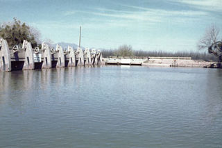
The Angostura Diversion Dam is a diversion dam on the Rio Grande in Sandoval County. New Mexico, near to Algodones and to the north of Bernalillo. The dam diverts water into the main irrigation canal serving the Albuquerque Division.
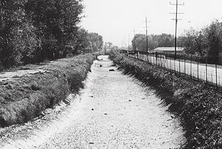
The San Acacia Diversion Dam is a structure built in 1934 for the Middle Rio Grande Conservancy District (MRGCD) near to San Acacia, New Mexico, United States. It diverts water from the Rio Grande into irrigation canals.

The Isleta Diversion Dam is a structure on the Rio Grande in the Albuquerque Basin near Isleta Village Proper, New Mexico that diverts water from the river into irrigation canals. There have been some negative environmental impacts due to changes in the river flow that affect the native fish and drying of the riverside land.
The Middle Rio Grande Project manages water in the Albuquerque Basin of New Mexico, United States. It includes major upgrades and extensions to the irrigation facilities built by the Middle Rio Grande Conservancy District and modifications to the channel of the Rio Grande to control sedimentation and flooding. The bulk of the work was done by the United States Bureau of Reclamation and the United States Army Corps of Engineers in the 1950s, but construction continued into the 1970s and maintenance is ongoing. The project is complementary to the San Juan-Chama Project, which transfers water from the San Juan River in the Colorado River Basin to the Rio Grande. Although distribution of water from the two projects is handled through separate allotments and contracts, there is some sharing of facilities including the river itself. The ecological impact on the river and the riparian zone was the subject of extended litigation after a group of environmentalists filed Rio Grande Silvery Minnow v. Bureau of Reclamation in 1999.
Heron Dam is a storage dam Rio Arriba County, in northern New Mexico in the southwestern United States, just north of the El Vado Dam. It is owned and operated by the United States Bureau of Reclamation. The dam is about 9 miles west of the town of Tierra Amarilla.

The American Diversion Dam is a diversion dam on the Rio Grande in El Paso, Texas. It is about 140 feet (43 m) north of the point where the west bank of the river enters Mexico, 3.5 miles (5.6 km) from the business center. The dam is operated by the International Boundary and Water Commission. It started operation in 1938.

The International Diversion Dam is a diversion dam on the Rio Grande in Ciudad Juárez. The dam is operated by the International Boundary and Water Commission, and diverts water into the Acequia Madre for use in irrigation in Mexico. Water is diverted under the terms of the 1906 treaty on usage of Rio Grande water between the United States and Mexico.
The Percha Diversion Dam is a structure built in 1918 on the Rio Grande in New Mexico, United States. It diverts water from the Rio Grande into the Rincon Valley Main Canal, an irrigation canal.

The Leasburg Diversion Dam is a structure completed in 1907 on the Rio Grande in New Mexico, United States. It diverts water from the Rio Grande into the 13.7 miles (22.0 km) long Leasburg Canal, which carries irrigation water into the upper Mesilla Valley, north of Las Cruces, New Mexico.
The Mesilla Diversion Dam is located in the Rio Grande about 40 miles (64 km) upstream of El Paso, Texas, about 6 miles (9.7 km) to the south of Las Cruces, New Mexico. It diverts water from the river for irrigation in the lower Mesilla Valley. The dam is owned by the United States Bureau of Reclamation, which built it, and is operated by the Elephant Butte Irrigation District.