The Imperial Diversion Dam is a concrete slab and buttress, ogee weir structure across the California/Arizona border, 18 miles (29 km) northeast of Yuma. Completed in 1938, the dam retains the waters of the Colorado River into the Imperial Reservoir before desilting and diversion into the All-American Canal, the Gila River, and the Yuma Project aqueduct. Between 1932 and 1940, the Imperial Irrigation District (IID) relied on the Inter-California Canal and the Imperial Canal and Alamo River.

Elephant Butte Dam or Elephant Butte Dike is a concrete gravity dam on the Rio Grande river near Truth or Consequences, New Mexico. The dam impounds Elephant Butte Reservoir, which is used mainly for agriculture, and also provides for recreation, hydroelectricity and flood control. The construction of the dam has reduced the flow of the Rio Grande to a small stream for most of the year, with water released only during the summer irrigation season, or during times of exceptionally heavy snow melt.

The Palo Verde Dam is a diversion dam on the Colorado River in La Paz County, Arizona, and Riverside County, California, in the southwestern United States, approximately 9 miles (14 km) northeast of Blythe. The dam is earthen and rockfill, built solely to divert water into irrigation canals serving the Palo Verde Irrigation District. It measures 1,850 feet (560 m) long at its crest, which is at an elevation of 283.5 feet (86.4 m), and stands 46 feet (14 m) high above the riverbed, containing approximately 175,000 cubic yards (134,000 m3) of material. Construction of the dam, which began in 1956 and ended in 1958, was authorized by the U.S. Bureau of Reclamation. The dam was constructed to raise the water level of the river because the upstream Hoover and Davis Dams blocked sediment, causing significant degradation of the riverbed that hampered water diversion.

Caballo Dam is an earthen dam on the Rio Grande about 15 miles (24 km) downstream from Truth or Consequences, New Mexico, United States. In conjunction with Elephant Butte Dam, which lies about 25 miles (40 km) upstream, it regulates the discharge of the river in the lower Rio Grande Valley of New Mexico. Caballo serves as an afterbay for the Elephant Butte Reservoir, i.e. it stores water released from Elephant Butte for hydroelectricity generation purposes and discharges it in the dry season to provide for irrigation agriculture downstream. The dam is an important part of the Rio Grande Project. A secondary purpose of the dam was to compensate for lost capacity in Elephant Butte Lake due to sedimentation.

Amistad Dam is a major embankment dam across the Rio Grande between Texas, United States, and Coahuila, Mexico. Built to provide irrigation water storage, flood control, and hydropower generation, it is the largest dam along the international boundary reach of the Rio Grande. The dam is over 6 miles (9.7 km) long, lies mostly on the Mexican side of the border, and forms Amistad Reservoir. It supplies water for irrigation in the Rio Grande Valley, 574 miles (924 km) upstream of the Rio Grande's mouth on the Gulf of Mexico at Brownsville, Texas/Matamoros, Tamaulipas.
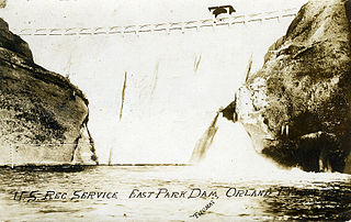
East Park Dam is an agricultural irrigation dam and reservoir built by the United States Bureau of Reclamation, on Little Stony Creek, about 30 miles (48 km) southwest of Orland, California on the northern end of the California Central Valley.

Gibson Dam is a concrete arch dam on the Sun River, a tributary of the Missouri River, about 60 miles (97 km) west of Great Falls, Montana in the United States. Located on the eastern edge of the Rocky Mountains, the dam was built by the U.S. Bureau of Reclamation (USBR) between 1926 and 1929 as part of the Sun River Project to develop about 93,000 acres (38,000 ha) of irrigated land in the Sun River Valley.

Platoro Dam is a dam in Conejos County, Colorado.

The Middle Rio Grande Conservancy District (MRGCD) was formed in 1925 to manage the irrigation systems and control floods in the Albuquerque Basin. It is responsible for the stretch of river from the Cochiti Dam in Sandoval County in the north, through Bernalillo County, Valencia County and Socorro County to the Elephant Butte Reservoir in the south. It manages the Angostura, Isleta and San Acacia diversion dams, which feed an extensive network of irrigation canals and ditches.

The Angostura Diversion Dam is a diversion dam on the Rio Grande in Sandoval County. New Mexico, near to Algodones and to the north of Bernalillo. The dam diverts water into the main irrigation canal serving the Albuquerque Division.

The San Acacia Diversion Dam is a structure built in 1934 for the Middle Rio Grande Conservancy District (MRGCD) near to San Acacia, New Mexico, United States. It diverts water from the Rio Grande into irrigation canals.

The Middle Rio Grande Project manages water in the Albuquerque Basin of New Mexico, United States. It includes major upgrades and extensions to the irrigation facilities built by the Middle Rio Grande Conservancy District and modifications to the channel of the Rio Grande to control sedimentation and flooding. The bulk of the work was done by the United States Bureau of Reclamation and the United States Army Corps of Engineers in the 1950s, but construction continued into the 1970s and maintenance is ongoing. The project is complementary to the San Juan-Chama Project, which transfers water from the San Juan River in the Colorado River Basin to the Rio Grande. Although distribution of water from the two projects is handled through separate allotments and contracts, there is some sharing of facilities including the river itself. The ecological impact on the river and the riparian zone was the subject of extended litigation after a group of environmentalists filed Rio Grande Silvery Minnow v. Bureau of Reclamation in 1999.
Heron Dam is a storage dam Rio Arriba County, in northern New Mexico in the southwestern United States, just north of the El Vado Dam. It is owned and operated by the United States Bureau of Reclamation. The dam is about 9 miles west of the town of Tierra Amarilla.

The American Diversion Dam is a diversion dam on the Rio Grande in El Paso, Texas. It is about 140 feet (43 m) north of the point where the west bank of the river enters Mexico, 3.5 miles (5.6 km) from the business center. The dam is operated by the International Boundary and Water Commission. It started operation in 1938.

The International Diversion Dam is a diversion dam on the Rio Grande in Ciudad Juárez. The dam is operated by the International Boundary and Water Commission, and diverts water into the Acequia Madre for use in irrigation in Mexico. Water is diverted under the terms of the 1906 treaty on usage of Rio Grande water between the United States and Mexico.
The Riverside Diversion Dam was a diversion dam on the Rio Grande to the southeast of El Paso, Texas. The dam was owned by the United States Bureau of Reclamation, and diverted water into the Riverside Canal for use in irrigation in the El Paso Valley. The dam became obsolete with completion of a cement-lined canal carrying water from the upstream American Diversion Dam to the head of the canal. It was partially removed in 2003.
The Percha Diversion Dam is a structure built in 1918 on the Rio Grande in New Mexico, United States. It diverts water from the Rio Grande into the Rincon Valley Main Canal, an irrigation canal.