Middle Rio Grande Project

Last updated
Middle Rio Grande Project
ElVadoDam.jpeg
General statistics
Begun1950
Storage dams El Vado Dam
Cochiti Dam
Diversion dams Angostura Diversion Dam
Isleta Diversion Dam
San Acacia Diversion Dam
Operations
Authorities United States Bureau of Reclamation United States Army Corps of Engineers Middle Rio Grande Conservancy District
Land irrigated89,652 acres (36,281 ha)

The Middle Rio Grande Project manages water in the Albuquerque Basin of New Mexico, United States. It includes major upgrades and extensions to the irrigation facilities built by the Middle Rio Grande Conservancy District and modifications to the channel of the Rio Grande to control sedimentation and flooding. The bulk of the work was done by the United States Bureau of Reclamation and the United States Army Corps of Engineers in the 1950s, but construction continued into the 1970s and maintenance is ongoing. The project is complementary to the San Juan–Chama Project, which transfers water from the San Juan River in the Colorado River Basin to the Rio Grande. Although distribution of water from the two projects is handled through separate allotments and contracts, there is some sharing of facilities including the river itself. The ecological impact on the river and the riparian zone was the subject of extended litigation after a group of environmentalists filed Rio Grande Silvery Minnow v. Bureau of Reclamation in 1999.

Contents

Background

The Rio Grande valley from Taos Pueblo downstream to Socorro has been continuously settled for longer than any other part of the United States. The Pueblo Indians diverted water from the river for irrigation. Spanish settlers who arrived in the 17th century established a more extensive system of acequias , or shared irrigation canals. More settlers arrived after the region was ceded to the United States in 1848, particularly after the American Civil War (1861-1865). Irrigation peaked in 1880 with 1,248,000 acres (505,000 ha) of cultivated land in the stretch of valley from Cochiti to San Marcial. The extent of cultivation began to decline after this due to water shortage, floods and waterlogging caused by aggradation of the riverbed, a rising water table and poor drainage. [1]

The Middle Rio Grande Conservancy District was established in 1925 to address these problems. It ran into financial difficulties and asked the Bureau of Reclamation to help investigate the problems and rehabilitation the irrigation facilities. The Flood Control Act of 30 June 1948 approved the comprehensive plan for the project, and also directed the Bureau of Reclamation to look into methods of reducing non-beneficial use of water by phreatic vegetation in the Rio Grande flood plains and its main tributaries above Caballo Reservoir. The Bureau of Reclamation and the Corps of Engineers worked together to plan the project. The Flood Control Act of 17 May 1950 approved completion of the plan. The Bureau of Reclamation was responsible for rehabilitating the El Vado dam, the irrigation and drainage works and the river channel. The Corps of Engineers was responsible for building flood control reservoirs and flood protection levees. [1]

Overview

Rio Grande basin, showing dams and diversions. Middle Rio Grande Project is in the northwest. Rio Grande dams and diversions.svg
Rio Grande basin, showing dams and diversions. Middle Rio Grande Project is in the northwest.
Cochiti reservoir Cochiti Lake shoreline.jpg
Cochiti reservoir

The Middle Rio Grande Project includes the river, dams, irrigation and drainage channels from Velarde south to the point where the river enters the Elephant Butte Reservoir. It also includes maintenance of the river near Truth or Consequences, New Mexico. The irrigation facilities, originally built by the conservancy district, irrigate up to 89,652 acres (36,281 ha), and include 30,000 acres (12,000 ha) of Indian water rights lands. The Bureau of Reclamation operates and maintains El Vado Dam and the river from Velarde to the Narrows of Elephant Butte Reservoir. The Middle Rio Grande Conservancy District operates the irrigation facilities, including the three diversion dams. The Corps of Engineers operates and maintains Cochiti Dam. [1]

Construction

Storage

In 1934-1935 the conservancy district built the El Vado Dam on the Rio Chama about 160 miles (260 km) north of Albuquerque to store irrigation water for use in dry periods. In 1954-1955 the Bureau of Reclamation rehabilitated the dam, a rolled-gravel embankment with a steel membrane on the upstream face, 230 feet (70 m) high with a crest length of 1,326 feet (404 m). In 1965-1968 the Bureau of Reclamation built a new outlet works to handle additional water delivered by the San Juan–Chama Project. The reservoir has a capacity of 196,500 acre-feet (one acre foot equaling 43,560 cubic feet (1,233 m3)). The dam feeds an 8,000 kilowatt hydroelectric power plant operated by Los Alamos County. [1]

In 1974-1975 the Cochiti Dam was constructed by the Corps of Engineers for flood control, inundating the former Cochiti Diversion Dam. It also provides irrigation water to the Cochiti Division. [1]

Diversions

The Bureau of Reclamation rehabilitated four diversion dams. Angostura Diversion Dam, rehabilitated in 1958, serves the Albuquerque Division. It is a concrete weir section 17 feet (5.2 m) high and 800 feet (240 m) long. Isleta Diversion Dam, rehabilitated in 1955, serves the Belen Division. It is a reinforced concrete structure 21 feet (6.4 m) high and 674 feet (205 m) long with 30 radial gates. San Acacia Diversion Dam, rehabilitated in 1957, serves the Socorro Division. It is 17 feet (5.2 m) high and 700 feet (210 m) long, with 29 radial gates. The Cochiti Division was formerly served by the Cochiti Diversion Dam, rehabilitated in 1958, but is now supplied directly from Cochiti Dam. [1]

Irrigation and drainage

The distribution and drainage system includes 202 miles (325 km) of canals, of which about 6 miles (9.7 km) are concrete lined; 580 miles (930 km) of laterals, of which about 4 miles (6.4 km) are concrete lined; and 405 miles (652 km) of open and concrete pipe drains, most of which are open section. From 1953 to 1961 the Bureau of Reclamation undertook extensive rehabilitation of canals, laterals, drains, and acequias throughout the project. In 1951 the Bureau of Reclamation began construction of the low-flow conveyance channel between San Acacia Diversion Dam and the Narrows of Elephant Butte, completing the job in 1959. In 1961 the Bureau of Reclamation completed modification of the headworks for the Socorro Main Canal north at San Acacia Diversion Dam. In 1975 the canal was tied into Drain Unit No. 7 Extension and then to Drain Unit No. 7 system. [1]

River

Between 1954 and 1962 the Bureau of Reclamation undertook river realignment and improvement between Velarde and the mouth of the Rio Puerco. Maintenance along a 149-mile (240 km) stretch of the river to control floods and reduce non-beneficial use of water through evapotranspiration is an ongoing requirement. The lengths of river maintained are 18 miles (29 km) in the Espanola area, 8 miles (13 km) in the Cochiti area, 24 miles (39 km) in the Albuquerque area, 28 miles (45 km) in the Belen area, 37 miles (60 km) in the Socorro area, 33 miles (53 km) in the San Marcial area and 1 mile (1.6 km) in the Truth or Consequences areas. Maintenance activities include clearing sediment plugs, pilot channeling, jetty installation, and maintaining the low-flow channel. The Bureau of Reclamation has been using alternative methods of channel maintenance since the late 1980s in an effort to improve the quality of the riverine and riparian habitats. [1]

Benefits

Rehabilitation of the irrigation system throughout the project has resulted in a more stable water supply to about 90,000 acres (36,000 ha) of irrigated land, including water for the six southern Indian pueblos of Cochiti, Santo Domingo, San Felipe, Santa Ana, Sandia, and Isleta, all of which are served by the Middle Rio Grande Conservancy District. This supports cultivation of alfalfa, barley, wheat, oats, corn, fruits and vegetables. The river maintenance program, coupled with the Corps of Engineers' flood control dams and system of levees, has greatly reduced the threat of uncontrolled flooding in the Middle Rio Grande Valley. [1]

Issues

Stabilization of the river channel through clearing, pilot channels, and jetty fields has resulted in the establishment of large wooded riparian areas called the bosque. Previously, large stands of trees were destroyed during heavy runoff years because the river meandered back and forth across the channel from levee to levee. The areas between the cleared floodway and the riverside levees are now filled with a permanent stand of large trees and other dense growths of vegetation. The invasion of nonnative species, as well as the lack of native tree regeneration, is of environmental concern. [1]

See also

Related Research Articles

<span class="mw-page-title-main">Pine Flat Dam</span> Dam in California, U.S.

Pine Flat Dam is a concrete gravity dam on the Kings River in the Central Valley of Fresno County, California United States. Situated about 28 miles (45 km) east of Fresno, the dam is 440 feet (130 m) high and impounds Pine Flat Lake, in the foothills of the Sierra Nevada just outside the boundary of Kings Canyon National Park. The dam's primary purpose is flood control, with irrigation, hydroelectric power generation and recreation secondary in importance.

<span class="mw-page-title-main">Navajo Dam</span> Dam in San Juan and Rio Arriba Counties, New Mexico

Navajo Dam is a dam on the San Juan River, a tributary of the Colorado River, in northwestern New Mexico in the United States. The 402-foot (123 m) high earthen dam is situated in the foothills of the San Juan Mountains about 44 miles (71 km) upstream and east of Farmington, New Mexico. It was built by the U.S. Bureau of Reclamation (Reclamation) in the 1960s to provide flood control, irrigation, domestic and industrial water supply, and storage for droughts. A small hydroelectric power plant was added in the 1980s.

<span class="mw-page-title-main">Cochiti Dam</span> Dam in New Mexico, USA

The Cochiti Dam is an earthen fill dam located on the Rio Grande in Sandoval County, New Mexico, approximately 50 miles (80 km) north of Albuquerque, New Mexico, in the United States. By volume of material, it is the 23rd largest dam in the world at 62,849,000 yd3 of material, one of the ten largest such dams in the United States, and the eleventh largest such dam in the world. Cochiti Dam is one of the four United States Army Corps of Engineers projects for flood and sediment control on the Rio Grande system, operating in conjunction with Abiquiu Dam, Galisteo Dam and Jemez Canyon Dam.

<span class="mw-page-title-main">Auburn Dam</span> Dam in Near Auburn, California

Auburn Dam was a proposed concrete arch dam on the North Fork of the American River east of the town of Auburn, California, in the United States, on the border of Placer and El Dorado Counties. Slated to be completed in the 1970s by the U.S. Bureau of Reclamation, it would have been the tallest concrete dam in California and one of the tallest in the United States, at a height of 680 feet (210 m) and storing 2,300,000 acre-feet (2.8 km3) of water. Straddling a gorge downstream of the confluence of the North and Middle Forks of the American River and upstream of Folsom Lake, it would have regulated water flow and provided flood control in the American River basin as part of Reclamation's immense Central Valley Project.

<span class="mw-page-title-main">Rio Grande Project</span>

The Rio Grande Project is a United States Bureau of Reclamation irrigation, hydroelectricity, flood control, and interbasin water transfer project serving the upper Rio Grande basin in the southwestern United States. The project irrigates 193,000 acres (780 km2) along the river in the states of New Mexico and Texas. Approximately 60 percent of this land is in New Mexico. Some water is also allotted to Mexico to irrigate some 25,000 acres (100 km2) on the south side of the river. The project was authorized in 1905, but its final features were not implemented until the early 1950s.

<span class="mw-page-title-main">Minidoka Project</span>

The Minidoka Project is a series of public works by the U.S. Bureau of Reclamation to control the flow of the Snake River in Wyoming and Idaho, supplying irrigation water to farmlands in Idaho. One of the oldest Bureau of Reclamation projects in the United States, the project involves a series of dams and canals intended to store, regulate and distribute the waters of the Snake, with electric power generation as a byproduct. The water irrigates more than a million acres (4,000 km²) of otherwise arid land, producing much of Idaho's potato crop. Other crops include alfalfa, fruit and sugar beets. The primary irrigation district lies between Ashton in eastern Idaho and Bliss in the southwestern corner of the state. Five main reservoirs collect water, distributing it through 1,600 miles (2,600 km) of canals and 4,000 miles (6,400 km) of lateral distribution ditches.

<span class="mw-page-title-main">Yuma Project</span> U.S. Bureau of Reclamation project

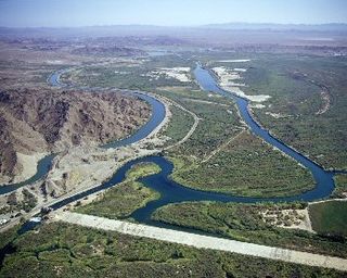
The Yuma Project is a U.S. Bureau of Reclamation project built to irrigate over 68,000 acres (280 km2) of land in Yuma County, Arizona and parts of Imperial County, California. The project is designed to exploit year-round farming conditions and water from the Colorado River. It consists of the Laguna Diversion Dam, pumping plants, a power plant, a 53-mile (85 km) system of canals, 218 miles (351 km) of lateral canals, levees and drains. The project began in 1903 and the majority of the work was completed by 1915. It was the first dam and reclamation project on the Colorado River and workers had to overcome many natural and logistical obstacles to build and maintain it. The Laguna Diversion Dam was replaced by the Imperial Dam as the Project's water source between 1941 and 1948. Today, it serves 275 farms and over 94,000 people.

<span class="mw-page-title-main">El Vado Dam</span> Dam in Rio Arriba County, New Mexico

El Vado Dam impounds the Rio Chama in the U.S. state of New Mexico, about 105 miles (169 km) north-northwest of New Mexico's largest city, Albuquerque and about 80 miles (130 km) northwest of the capital city of Santa Fe. The earth-filled structure forms El Vado Lake, a storage reservoir for the Middle Rio Grande Project, and has been designated as a New Mexico Historic Civil Engineering Landmark by the American Society of Civil Engineers.

<span class="mw-page-title-main">San Juan–Chama Project</span> Water management project in New Mexico and Colorado

The San Juan–Chama Project is a U.S. Bureau of Reclamation interbasin water transfer project located in the states of New Mexico and Colorado in the United States. The project consists of a series of tunnels and diversions that take water from the drainage basin of the San Juan River – a tributary of the Colorado River – to supplement water resources in the Rio Grande watershed. The project furnishes water for irrigation and municipal water supply to cities along the Rio Grande including Albuquerque and Santa Fe.

<span class="mw-page-title-main">Platoro Dam</span> Dam in Conejos County, Colorado

Platoro Dam is a dam in Conejos County, Colorado.

San Acacia is a small unincorporated community and census-designated place in Socorro County, New Mexico, United States. It was once a prosperous railway town, but is now largely deserted. There is a nearby diversion dam on the Rio Grande, important in irrigation.

<span class="mw-page-title-main">Middle Rio Grande Conservancy District</span>

The Middle Rio Grande Conservancy District (MRGCD) was formed in 1925 to manage the irrigation systems and control floods in the Albuquerque Basin. It is responsible for the stretch of river from the Cochiti Dam in Sandoval County in the north, through Bernalillo County, Valencia County and Socorro County to the Elephant Butte Reservoir in the south. It manages the Angostura, Isleta and San Acacia diversion dams, which feed an extensive network of irrigation canals and ditches.

<span class="mw-page-title-main">Angostura Diversion Dam</span> Dam in Sandoval County, New Mexico

The Angostura Diversion Dam is a diversion dam on the Rio Grande in Sandoval County. New Mexico, near to Algodones and to the north of Bernalillo. The dam diverts water into the main irrigation canal serving the Albuquerque Division.

The San Acacia Diversion Dam is a structure built in 1934 for the Middle Rio Grande Conservancy District (MRGCD) near to San Acacia, New Mexico, United States. It diverts water from the Rio Grande into irrigation canals.

<span class="mw-page-title-main">Isleta Diversion Dam</span> Dam in near Isleta, New Mexico

The Isleta Diversion Dam is a structure on the Rio Grande in the Albuquerque Basin near Isleta Village Proper, New Mexico that diverts water from the river into irrigation canals. There have been some negative environmental impacts due to changes in the river flow that affect the native fish and drying of the riverside land.

<i>Rio Grande Silvery Minnow v. Bureau of Reclamation</i> Supreme Court case

Rio Grande Silvery Minnow v. Bureau of Reclamation, called Rio Grande Silvery Minnow v. Keys in its earlier phases, was a case launched in 1999 by a group of environmentalists against the United States Bureau of Reclamation and the United States Army Corps of Engineers alleging violations of the Endangered Species Act and the National Environmental Policy Act. The case resulted in significant changes to water and river management in the Middle Rio Grande Basin of New Mexico in an effort to reverse the damage that had been done to the habitat of two endangered species.

<span class="mw-page-title-main">Heron Dam</span> Dam in Rio Arriba County, New Mexico

Heron Dam is a storage dam Rio Arriba County, in northern New Mexico in the southwestern United States, just north of the El Vado Dam. It is owned and operated by the United States Bureau of Reclamation. The dam is about 9 miles west of the town of Tierra Amarilla.

The Riverside Diversion Dam was a diversion dam on the Rio Grande to the southeast of El Paso, Texas. The dam was owned by the United States Bureau of Reclamation, and diverted water into the Riverside Canal for use in irrigation in the El Paso Valley. The dam became obsolete with completion of a cement-lined canal carrying water from the upstream American Diversion Dam to the head of the canal. It was partially removed in 2003.

<span class="mw-page-title-main">Rio Grande Valley (New Mexico)</span> River valley of the Rio Grande in New Mexico, United States

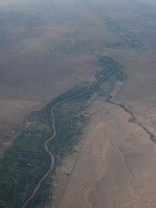
The Rio Grande Valley is the river valley carved out by the Rio Grande as it flows through the American Southwest and northeastern Mexico, forming a part of the border region. In the US state of New Mexico, the river flows mostly north to south, and forms a valley near Cochiti Pueblo to the state line near El Paso, Texas along the floors of the large sedimentary basins of the Rio Grande Rift, and includes the narrow sections between the basins. It has been historically settled first by the Pueblo peoples, the Spanish, the Mexicans, and finally Anglo-Americans. As the largest river in the state, some of its most populous cities are located wholly or partially in the valley, including Albuquerque, New Mexico's largest city.

References

Citations

  1. 1 2 3 4 5 6 7 8 9 10 Middle Rio Grande Project - USBR.

Sources

PD-icon.svg This article incorporates public domain material from websites or documents of the United States Bureau of Reclamation .