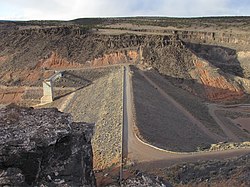
The earthen dam was constructed in 1953 by the United States Army Corps of Engineers, with a height of 150 feet and a length at its crest of 870 feet.[1] It impounds the Jemez River creating Jemez Canyon Reservoir for flood control and storm water management in the spring and early summer seasons.[2] The dam is owned by the Corps of Engineers, and operated by the Corps and the Cochiti Lake Project Office.
Originally, the dam operated on a 48-hour hold regiment after storm events and during the spring runoff. This was to allow sediments to settle out of suspension before releasing the waters downstream into the Rio Grande. In early 1979, a permanent pool of 2,000 acre-feet was established behind the dam for sediment control purposes "to decrease aggradation in the Rio Grande channel and thereby maintain or improve channel conveyance for Rio Grande Compact deliveries." In October of 1984, the pool was increased to 3,000 acre-feet.[3]
In 2001, the pool was gradually drained in order to deliver sediment directly downstream to the sediment-deficient Rio Grande and increase water availability. This caused a sharp reduction in recreation at the now dry reservoir, and in 2015, the area was closed to the public. Today, without sediment control or recreation functions, the dam operates solely for flood-control purposes.[3]
Recreation
The reservoir it creates, Jemez Canyon Reservoir, has a normal water surface of 2.2 square miles and a maximum capacity of 264,700 acre-feet.[4] Recreation was historically high when there was a permanent pool of 2,000-3,000 acre feet due to its proximity to the growing Albuquerque metropolitan area.[3]
Today, the reservoir is left dry, and recreation is limited. There is no access to the dam or lakebed. All land surrounding the reservoir, including a small day-use area with picnic facilities and a scenic overlook, is the property of Santa Ana Pueblo. Access is restricted to the day-use area only.[5]
Gallery
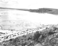
Jemez Canyon Dam with a full reservoir in May 1958
This page is based on this Wikipedia article Text is available under the CC BY-SA 4.0 license; additional terms may apply. Images, videos and audio are available under their respective licenses.