Sumner Dam

Last updated
Sumner Dam
Sumner Lake Dam New Mexico 2023.jpg
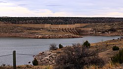
Upstream side of Sumner Dam
USA New Mexico relief location map.svg
Red pog.svg
Location of Sumner Dam in New Mexico
CountryUnited States
Location De Baca County, New Mexico
Coordinates 34°36′29″N104°23′11″W / 34.60817°N 104.38634°W / 34.60817; -104.38634
PurposeIrrigation
Dam and spillways
Height164 feet (50 m)
Reservoir
Total capacity43,800 acre-feet (54,000,000 m3)

Sumner Dam is a dam on the Pecos River in De Baca County in eastern New Mexico.

The dam was built by the United States Bureau of Reclamation between 1935 and 1939, a project governed by the Bureau in conjunction with the local Carlsbad Irrigation District. [1] Construction was done by the Bureau with the help of workers of the Works Progress Administration and the Civilian Conservation Corps; some remnants of their artistic rockwork are the five rock bridges on the main road on the east side of the lake. [2]

The dam is 164 feet tall and impounds the Pecos with a total capacity of about 43,800 acre-feet. The resulting reservoir, Lake Sumner, is the location of the community of Lake Sumner, New Mexico, and of Sumner Lake State Park. [3] The state park was established in 1966 on a 50-year lease from the Bureau of Reclamation (expiring in 2016), and originally called Alamogordo Lake State Park. [4] The lake was completely drained for irrigation needs in 2001, destroying fish stocks, but recreational use has since rebounded. The state park is unusual in providing public access to the riparian zone below the dam. [5]

Related Research Articles

<span class="mw-page-title-main">Pecos River</span> River in New Mexico and Texas, United States

The Pecos River originates in north-central New Mexico and flows into Texas, emptying into the Rio Grande. Its headwaters are on the eastern slope of the Sangre de Cristo mountain range in Mora County north of Pecos, New Mexico, at an elevation of over 12,000 feet (3,700 m). The river flows for 926 miles (1,490 km) before reaching the Rio Grande near Del Rio. Its drainage basin encompasses about 44,300 square miles (115,000 km2).

The Salt River Project (SRP) encompasses two separate entities: the Salt River Project Agricultural Improvement and Power District, an agency of the state of Arizona that serves as an electrical utility for the Phoenix metropolitan area, and the Salt River Valley Water Users' Association, a utility cooperative that serves as the primary water provider for much of central Arizona. It is one of the primary public utility companies in Arizona.

<span class="mw-page-title-main">Thief Valley Reservoir</span> Reservoir in Eastern Oregon, United States

Thief Valley Reservoir is a large reservoir on the Powder River in Eastern Oregon, United States. Primarily used for irrigation purposes, it lies at an elevation of approximately 3,000 feet, covers an area of 740 acres, and impounds 17,600 acre-feet. It provides good angling opportunities for rainbow trout in years of high water.

<span class="mw-page-title-main">Folsom Dam</span> Dam in Folsom, California

Folsom Dam is a concrete gravity dam on the American River of Northern California in the United States, about 25 mi (40 km) northeast of Sacramento. The dam is 340 ft (100 m) high and 1,400 ft (430 m) long, flanked by earthen wing dams. It was completed in 1955, and officially opened the following year.

<span class="mw-page-title-main">Geography of New Mexico</span> Overview of the Geography of New Mexico

With a total area of 121,590 square miles (314,900 km2), New Mexico is the fifth-largest state, after Alaska, Texas, California, and Montana. Its eastern border lies along 103°W longitude with the state of Oklahoma, and 2.2 miles west of 103°W longitude with Texas. On the southern border, Texas makes up the eastern two-thirds, while the Mexican states of Chihuahua and Sonora make up the western third, with Chihuahua making up about 90% of that. The western border with Arizona runs along the 109° 03'W longitude. The southwestern corner of the state is known as the Bootheel. The 37°N parallel forms the northern boundary with Colorado. The states of New Mexico, Colorado, Arizona, and Utah come together at the Four Corners in New Mexico's northwestern corner. Its surface water area is about 292 square miles (760 km2).

<span class="mw-page-title-main">Conchas Dam</span> Dam on the Canadian River in San Miguel County, New Mexico, United States

Conchas Dam is a dam on the Canadian River in San Miguel County, New Mexico in the United States, about 50 miles (80 km) northeast of Santa Rosa. Forming Conchas Lake, it is a concrete gravity dam flanked by earthen wing dikes, standing 235 feet (72 m) high with a total length of 19,500 feet (5,900 m). The dam serves mainly for irrigation water supply and flood control and is operated by the U.S. Army Corps of Engineers.

<span class="mw-page-title-main">Lucky Peak Dam</span> Dam in Ada County, Idaho

Lucky Peak Dam is a rolled earth and gravel fill embankment dam in the western United States, located on the Boise River in southwestern Idaho. In Ada County east of Boise, it is directly downstream of Arrowrock Dam, a concrete arch dam completed in 1915. At the time of its construction in the early 1950s, Lucky Peak's primary purpose was flood control, with a secondary purpose of irrigation. The normal operating elevation of the full reservoir is 3,055 feet (931 m) above sea level, the empty reservoir's elevation is 2,824 feet (861 m).

<span class="mw-page-title-main">Unity Lake State Recreation Site</span>

Unity Lake State Recreation Site is a state park in the U.S. state of Oregon, administered by the Oregon Parks and Recreation Department.

<span class="mw-page-title-main">Sumner Lake State Park</span> State park in New Mexico, United States

Sumner Lake State Park is a state park in De Baca County, New Mexico, United States, located on the eastern plains about 8 miles (13 km) northwest of Fort Sumner.

<span class="mw-page-title-main">Amistad Dam</span> Dam in Texas / Acuña Municipality, Coahuila

Amistad Dam is a major embankment dam across the Rio Grande between Texas, United States, and Coahuila, Mexico. Built to provide irrigation water storage, flood control, and hydropower generation, it is the largest dam along the international boundary reach of the Rio Grande. The dam is over 6 miles (9.7 km) long, lies mostly on the Mexican side of the border, and forms Amistad Reservoir. It supplies water for irrigation in the Rio Grande Valley, 574 miles (924 km) upstream of the Rio Grande's mouth on the Gulf of Mexico at Brownsville, Texas/Matamoros, Tamaulipas.

Bull Lake Dam is a dam in Fremont County, Wyoming within the Wind River Indian Reservation.

<span class="mw-page-title-main">Medicine Creek Dam</span>

Medicine Creek Dam is a dam in Frontier County, Nebraska.

<span class="mw-page-title-main">Bonny Dam</span> Dam in Yuma County, Colorado, US

Bonny Dam is a dam in Yuma County, Colorado, in the eastern part of the state.

Stateline Dam is a dam in Summit County, Utah, less than a half-mile south of the Utah-Wyoming state line.

<span class="mw-page-title-main">Santa Rosa Dam</span> Dam in Guadalupe County, New Mexico

Santa Rosa Dam is a dam in Guadalupe County, New Mexico.

Midview Dam is a dam in Duchesne County, Utah, about twelve miles east of the town of Duchesne.

<span class="mw-page-title-main">Stony Gorge Dam</span> Dam in Glenn County, California

Stony Gorge Dam is a dam in Glenn County, California.

Silver Jack Dam is a dam in Gunnison County, Colorado.

<span class="mw-page-title-main">Brantley Dam</span> Dam in Eddy County, New Mexico

Brantley Dam is a flood-control and irrigation water-storage dam on the Pecos River in Eddy County, New Mexico, about 13 miles (21 km) north of Carlsbad, New Mexico, and 10 miles (16 km) upstream from Avalon Dam.

<span class="mw-page-title-main">Avalon Dam</span> Dam in Eddy County, New Mexico

Avalon Dam is a small dam on the Pecos River about 5 miles (8.0 km) north of Carlsbad, New Mexico, United States. The dam is a storage and regulating reservoir, and diverts water into the main canal of the Carlsbad Project, an irrigation scheme.

References

  1. "Dam details - Sumner Dam - Bureau of Reclamation". Archived from the original on 2012-09-25. Retrieved 2014-01-07.
  2. "Archived copy" (PDF). Archived from the original (PDF) on 2012-06-19. Retrieved 2012-07-23.{{cite web}}: CS1 maint: archived copy as title (link)
  3. "Sumner". Archived from the original on 2012-06-18. Retrieved 2012-07-23.
  4. "Archived copy" (PDF). Archived from the original (PDF) on 2012-06-19. Retrieved 2012-07-23.{{cite web}}: CS1 maint: archived copy as title (link)
  5. "Archived copy" (PDF). Archived from the original (PDF) on 2012-06-19. Retrieved 2012-07-23.{{cite web}}: CS1 maint: archived copy as title (link)