Hickman Natural Bridge

Last updated

Hickman Natural Bridge
Hickman Bridge Capitol Reef National Park USA.jpg
View of the bridge
USA Utah location map.svg
Red pog.svg
Hickman Bridge
Location in Utah
Coordinates: 38°17′29″N111°14′05″W / 38.2913688°N 111.2346135°W / 38.2913688; -111.2346135 [1]
Location Capitol Reef National Park, Utah
Dimensions
  Length133 ft (41 m)
  Height125 ft (38 m)
Elevation5,693 ft (1,735 m)
[1]

Hickman Natural Bridge is a 125-foot-tall (38 m) natural bridge located in Capitol Reef National Park, Wayne County, Utah, United States. The formation spans 133 feet (40 meters), making it one of the largest rock spans in the park. [2] [3] [4]

Contents

Geology

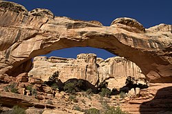
The sandstone bridge was carved out of a geological formation known as the Kayenta Formation 65 million years ago, formed by flowing water coursing down the rock fin and eventually breaking through the soft shale. Large basalt and andesite boulders of volcanic origin were deposited by melting glacial debris flows from the cliffs of Boulder and Thousand Lakes mountains west of the park. [5] [6] Hickman Bridge spans what is now a dry wash. [7] [8]

History

A granary constructed by the Fremont peoples Crnp moki closeup 041031.jpg
A granary constructed by the Fremont peoples

Because of its close proximity to the Fremont River, the Capitol Reef region was first settled by prehistoric Fremont people, followed by the Paiutes between 300 and 1300 C.E. [9] [10] Petroglyph panels as well as the remains of a granary and pithouse can be seen on the canyon walls and along the trail.

1958 travel brochure featuring Hickman Bridge on the coverpage Cover of map, with view under Hickman Bridge. (d12d3eb3-1d7b-41ab-8798-f9ac55a12efd).jpg
1958 travel brochure featuring Hickman Bridge on the coverpage

Mormons settled the valley near the bridge in the 1880s and established nearby Junction (later renamed Fruita). [11] After the region was federally protected in 1937, the Civilian Conservation Corps, responsible for constructing the early infrastructure of the park, carved out the trail, and Hickman Bridge was later named after local school administrator Joseph Hickman, who was previously elected to the Utah State Legislature in 1924. [2] [12]

A significant rockfall occurred at the Hickman Bridge Trailhead on March 23, 2013, and the trail was closed upon discovery of the debris. [13] With the assistance of crews from nearby Canyonlands National Park and Rocky Mountain National Park in Colorado, the trail was realigned around the debris pile and officially reopened 6 months later in November. [14]

Ecology

Native to the southwestern United States, Utah juniper trees can be seen around the canyon throughout the trail. Mormon tea, pinyon pine and prickly pear cactus are also abundant in the region. [9] Native animals such as bighorn sheep and mountain lions inhabit the area and occasionally pose a risk to hikers.

Climate

Spring and fall are the most favorable seasons to visit Hickman Bridge. According to the Köppen climate classification system, it is located in a Cold semi-arid climate zone, which is defined by the coldest month having an average mean temperature below 32 °F (0 °C), and at least 50% of the total annual precipitation being received during the spring and summer. This desert climate receives less than 10 inches (250 millimeters) of annual rainfall, and winter snowfall is generally light.

Access

The bridge can be accessed via a 1.8 mile out-and-back trail from the Hickman Bridge trailhead on Utah State Route 24 near Torrey, Utah. The trail goes under and around the natural bridge, and is considered moderate difficulty by the National Park Service due to switchbacks and the trail length. The trail follows the Fremont River before entering the valley, and also gives access to the Rim Overlook Trail, Navajo Knobs Trail, Capitol Dome, and Navajo Dome. [15] [16]

See also

Related Research Articles

<span class="mw-page-title-main">Bryce Canyon National Park</span> National park in Utah, United States

Bryce Canyon National Park is an American national park located in southwestern Utah. The major feature of the park is Bryce Canyon, which despite its name, is not a canyon, but a collection of giant natural amphitheaters along the eastern side of the Paunsaugunt Plateau. Bryce is distinctive due to geological structures called hoodoos, formed by frost weathering and stream erosion of the river and lake bed sedimentary rock. The red, orange, and white colors of the rocks provide spectacular views for park visitors. Bryce Canyon National Park is much smaller and sits at a much higher elevation than nearby Zion National Park. The rim at Bryce varies from 8,000 to 9,000 feet.

<span class="mw-page-title-main">Rainbow Bridge National Monument</span> Natural bridge in San Juan County, Utah, United States

Rainbow Bridge is a natural arch in southern Utah, United States. With a span of 275 feet (84 m), as reported in 1974 by the Bureau of Reclamation, and height of 290 feet (88 m), it is one of the largest natural arches in the world. At the top it is 42 feet (13 m) thick and 33 feet (10 m) wide. The bridge, which is of cultural importance to a number of area Native American tribes, has been designated a Traditional Cultural Property by the National Park Service. Rainbow Bridge National Monument was protected in 1910, and it is administered by Glen Canyon National Recreation Area.

<span class="mw-page-title-main">Capitol Reef National Park</span> National park in Utah, United States

Capitol Reef National Park is an American national park in south-central Utah. The park is approximately 60 miles (100 km) long on its north–south axis and just 6 miles (10 km) wide on average. The park was established in 1971 to preserve 241,904 acres of desert landscape and is open all year, with May through September being the highest visitation months.

<span class="mw-page-title-main">Colorado Plateau</span> Plateau in southwestern United States

The Colorado Plateau, also known as the Colorado Plateau Province, is a physiographic and desert region of the Intermontane Plateaus, roughly centered on the Four Corners region of the southwestern United States. This province covers an area of 336,700 km2 (130,000 mi2) within western Colorado, northwestern New Mexico, southern and eastern Utah, northern Arizona, and a tiny fraction in the extreme southeast of Nevada. About 90% of the area is drained by the Colorado River and its main tributaries: the Green, San Juan, and Little Colorado. Most of the remainder of the plateau is drained by the Rio Grande and its tributaries.

<span class="mw-page-title-main">Glen Canyon National Recreation Area</span> Protected area in Arizona and Utah, US

Glen Canyon National Recreation Area is a national recreation area and conservation unit of the United States National Park Service that encompasses the area around Lake Powell and lower Cataract Canyon in Utah and Arizona, covering 1,254,429 acres (5,076.49 km2) of mostly rugged high desert terrain. The recreation area is named for Glen Canyon, which was flooded by the Glen Canyon Dam, completed in 1966, and is now mostly submerged beneath the waters of Lake Powell.

<span class="mw-page-title-main">Geology of the Capitol Reef area</span>

The exposed geology of the Capitol Reef area presents a record of mostly Mesozoic-aged sedimentation in an area of North America in and around Capitol Reef National Park, on the Colorado Plateau in southeastern Utah.

<span class="mw-page-title-main">Wingate Sandstone</span> Geologic formation across the Colorado Plateau, USA

The Wingate Sandstone is a geologic formation in the Glen Canyon Group of the Colorado Plateau province of the United States which crops out in northern Arizona, northwest Colorado, Nevada, and Utah.

<span class="mw-page-title-main">Kayenta Formation</span> Jurassic sandstone formation of the southwestern United States

The Kayenta Formation is a geological formation in the Glen Canyon Group that is spread across the Colorado Plateau province of the United States, including northern Arizona, northwest Colorado, Nevada, and Utah. Traditionally has been suggested as Sinemurian-Pliensbachian, but more recent dating of detrital zircons has yielded a depositional age of 183.7 ± 2.7 Ma, thus a Pliensbachian-Toarcian age is more likely. A previous depth work recovered a solid "Carixian" age from measurements done in the Tenney Canyon. More recent works have provided varied datations for the layers, with samples from Colorado and Arizona suggesting 197.0±1.5-195.2±5.5 Ma, while the topmost section is likely Toarcian or close in age, maybe even recovering terrestrial deposits coeval with the Toarcian Oceanic Anoxic Event. This last age asignation also correlated the Toarcian Vulcanism on the west Cordilleran Magmatic Arc, as the number of grains from this event correlate with the silt content in the sandstones of the upper layers.

<span class="mw-page-title-main">Arches National Park</span> National park in Utah, United States

Arches National Park is a national park in eastern Utah, United States. The park is adjacent to the Colorado River, 4 mi (6 km) north of Moab, Utah. The park contains more than 2,000 natural sandstone arches, including the well-known Delicate Arch, which constitute the highest density of natural arches in the world. It also contains a variety of other unique geological resources and formations. The national park lies above an underground evaporite layer or salt bed, which is the main cause of the formation of the arches, spires, balanced rocks, sandstone fins, and eroded monoliths in the area.

<span class="mw-page-title-main">Zion National Park</span> National park in Utah, United States

Zion National Park is an American national park located in southwestern Utah near the town of Springdale. Located at the junction of the Colorado Plateau, Great Basin, and Mojave Desert regions, the park has a unique geography and a variety of life zones that allow for unusual plant and animal diversity. Numerous plant species as well as 289 species of birds, 75 mammals, and 32 reptiles inhabit the park's four life zones: desert, riparian, woodland, and coniferous forest. Zion National Park includes mountains, canyons, buttes, mesas, monoliths, rivers, slot canyons, and natural arches. The lowest point in the park is 3,666 ft (1,117 m) at Coalpits Wash and the highest peak is 8,726 ft (2,660 m) at Horse Ranch Mountain. A prominent feature of the 229-square-mile (590 km2) park is Zion Canyon, which is 15 miles (24 km) long and up to 2,640 ft (800 m) deep. The canyon walls are reddish and tan-colored Navajo Sandstone eroded by the North Fork of the Virgin River. The park attracted 5 million visitors in 2023.

<span class="mw-page-title-main">Bridge Mountain (Utah)</span> Mountain in the United States

Bridge Mountain is a 6,803-foot (2,074 m) mountain made of Navajo Sandstone in Zion National Park in Washington County, of southwest Utah, United States.

<span class="mw-page-title-main">The West Temple</span> Mountain in the state of Utah

The West Temple is a prominent 7,810-foot mountain summit composed of Navajo Sandstone in Zion National Park in Washington County of Utah, United States. The West Temple, the highest feature in Zion Canyon, was originally called "Temp-o-i-tin-car-ur" meaning "Mountain without a trail" by the Paiute people. It was called Steamboat Mountain by local Mormon settlers before 1934, when the USGS officially changed it to its present name, which was applied by John Wesley Powell during his explorations in 1872. West Temple is situated two miles northwest of Springdale, Utah, one mile northeast of Mount Kinesava, and two miles west of the park headquarters. It is one of the notable landmarks in the park. The nearest higher peak is Windy Peak, 10.46 miles (16.83 km) to the north. Precipitation runoff from the mountain drains into tributaries of the Virgin River.

<span class="mw-page-title-main">Chimney Rock (Capitol Reef National Park)</span> Geological formation in the American state of Utah

Chimney Rock is a 6,420-foot (1,960 m) summit in Capitol Reef National Park in Wayne County, Utah, United States. This landmark is situated 2.5 mi (4.0 km) northwest of the park's visitor center, towering over 300 feet (91 m) above Utah State Route 24. Chimney Rock is also 2.5 mi (4.0 km) northwest of another of the park's landmarks, The Castle. Precipitation runoff from this feature ends up in the Colorado River drainage basin. The Chimney Rock Trail is a 3.5-mile loop trail that takes hikers to a view of Chimney Rock from above Mummy Cliffs.

<span class="mw-page-title-main">Ferns Nipple</span> Summit in the state of Utah, U.S.A.

Ferns Nipple is a 7,065-foot (2,153-meter) elevation summit located in Capitol Reef National Park, in Wayne County of Utah, United States. This iconic landmark is situated 4 mi (6.4 km) southeast of the park's visitor center. Precipitation runoff from this feature is drained by tributaries of the Fremont River, which in turn is within the Colorado River drainage basin. Folklore attributes this geological feature's naming to outlaw Butch Cassidy and his favored girlfriend named Fern.

<span class="mw-page-title-main">Pectols Pyramid</span> Summit in the state of Utah, U.S.A.

Pectols Pyramid is a 6,211-foot (1,893-meter) elevation summit located in Capitol Reef National Park, in Wayne County of Utah, United States. This iconic landmark is situated 2 mi (3.2 km) southeast of the park's visitor center, 1 mi (1.6 km) south of Navajo Dome, and 0.5 mi (0.80 km) southwest of Capitol Dome. Precipitation runoff from this feature is drained by the Fremont River, which in turn is within the Colorado River drainage basin. This geological feature's name honors Ephraim Portman Pectol (1875–1947), booster and founder of what would become Capitol Reef National Monument in 1937.

<span class="mw-page-title-main">Capitol Dome (Utah)</span> Mountain in the state of Utah, U.S.A.

Capitol Dome is a 6,120-foot-elevation (1,870 m) summit located in Capitol Reef National Park, in Wayne County, Utah, United States. This iconic landmark is situated 2.5 miles (4.0 km) east of the park's visitor center, and 0.85 mi (1.37 km) southeast of Navajo Dome. Precipitation runoff from this feature is drained by tributaries of the Fremont River, which in turn is within the Colorado River drainage basin. It towers 800 feet (240 m) above the Fremont River and State Route 24. This geological feature's dome-like shape reminded early explorers and settlers of the dome of the United States Capitol in Washington D.C., and lent the park its name.

<span class="mw-page-title-main">Navajo Dome</span> Summit in the state of Utah, U.S.A.

Navajo Dome is a 6,489-foot (1,978-meter) elevation summit located in Capitol Reef National Park, in Wayne County of Utah, United States. This iconic landmark is situated 2 mi (3.2 km) east of the park's visitor center, and 0.85 mi (1.37 km) northwest of Capitol Dome. Precipitation runoff from this feature is drained by the Fremont River, which in turn is within the Colorado River drainage basin. It rises 1,100 feet above the Fremont River and Highway 24, from which it is visible. The approach to the base of this peak is made via the Hickman Bridge Trail. This geological feature's descriptive name derives from its Navajo Sandstone composition and dome-like shape.

<span class="mw-page-title-main">EPH Hanks Tower</span> Summit in the state of Utah, U.S.

Eph Hanks Tower is a 6,540-foot (1,990-meter) elevation summit located in Capitol Reef National Park, in Wayne County of Utah, United States. This landmark is situated 8 mi (13 km) southeast of the park's visitor center, 3.5 mi (5.6 km) south-southeast of Ferns Nipple, and 1.4 mi (2.3 km) south-southwest of Golden Throne, at the mouth of Capitol Gorge where the Capitol Reef Scenic Drive road ends. It towers 900 feet above the picnic area below its north aspect. Precipitation runoff from this feature is drained by Capitol Wash and Pleasant Creek, a tributary of the Fremont River, which in turn is within the Colorado River drainage basin. This geological feature is named after Ephraim Knowlton Hanks (1826–1896), a Mormon pioneer and first permanent settler in the Capitol Reef area, who with his family homesteaded in the Pleasant Creek area of Capitol Reef in 1881. Ephraim Hanks' Floral Ranch on Pleasant Creek supposedly offered a safe retreat for polygamists along the Mormon underground railroad.

<span class="mw-page-title-main">Cathedral Mountain (Capitol Reef National Park)</span> Summit in the American state of Utah

Cathedral Mountain is a 6,924-foot (2,110 m) summit located in Capitol Reef National Park, in Wayne County of Utah, United States.

<span class="mw-page-title-main">Cassidy Arch</span> Natural rock arch in Utah, US

Cassidy Arch is a large natural arch located in Capitol Reef National Park, Utah. The formation is considered one of the more popular attractions in the park. The arch sits 400 feet above the Scenic Drive and the Grand Wash Trail.

References

  1. 1 2 "Hickman Natural Bridge". Geographic Names Information System . United States Geological Survey, United States Department of the Interior.
  2. 1 2 "Hickman Bridge in Capitol Reef National Park". Parkcation.com. Retrieved July 12, 2023.
  3. "Hickman Bridge Trail, Capitol Reef National Park". The American Southwest. Retrieved July 10, 2023.
  4. "Hickman Bridge, Capitol Reef National Park". climb-utah.com. Retrieved July 24, 2023.
  5. "Hickman Natural Bridge - 2.05 miles". Protrails.com. Retrieved October 2, 2023.
  6. "Hickman Bridge – Capitol Reef National Park". Takeahike.us. Retrieved July 10, 2023.
  7. "Hickman Bridge Hike". University of Utah. Retrieved July 10, 2023.
  8. "Hickman Bridge and Navajo Knobs". Visit Utah.com. Retrieved July 10, 2023.
  9. 1 2 "Hickman Bridge Trail Guide" (PDF). NPS History.com. Retrieved July 26, 2023.
  10. "Fremont Culture". National Park Service. Retrieved July 10, 2023.
  11. "History & Culture". Capitol Reef National Park. National Park Service. Retrieved February 24, 2010.
  12. "Timeline of Capitol Reef National Park". National Park Service. Retrieved October 2, 2023.
  13. "Hickman Bridge Trailhead Temporary Closures". National Park Service. March 10, 2014.
  14. "Hickman Bridge Trail Reopens". National Park Service. November 29, 2013.
  15. "Hickman Bridge Trail". Alltrails.com. Retrieved July 10, 2023.
  16. "Trail Guide". Capitol Reef National Park. National Park Service. Retrieved July 10, 2023.