
Capitol Reef National Park is an American national park in south-central Utah. The park is approximately 60 miles (100 km) long on its north–south axis and just 6 miles (10 km) wide on average. The park was established in 1971 to preserve 241,904 acres of desert landscape and is open all year, with May through September being the highest visitation months.

The Colorado Plateau, also known as the Colorado Plateau Province, is a physiographic and desert region of the Intermontane Plateaus, roughly centered on the Four Corners region of the southwestern United States. This province covers an area of 336,700 km2 (130,000 mi2) within western Colorado, northwestern New Mexico, southern and eastern Utah, northern Arizona, and a tiny fraction in the extreme southeast of Nevada. About 90% of the area is drained by the Colorado River and its main tributaries: the Green, San Juan, and Little Colorado. Most of the remainder of the plateau is drained by the Rio Grande and its tributaries.

The exposed geology of the Capitol Reef area presents a record of mostly Mesozoic-aged sedimentation in an area of North America in and around Capitol Reef National Park, on the Colorado Plateau in southeastern Utah.

The Navajo Sandstone is a geological formation in the Glen Canyon Group that is spread across the U.S. states of southern Nevada, northern Arizona, northwest Colorado, and Utah as part of the Colorado Plateau province of the United States.

The Wingate Sandstone is a geologic formation in the Glen Canyon Group of the Colorado Plateau province of the United States which crops out in northern Arizona, northwest Colorado, Nevada, and Utah.

The Canyons of the Escalante is a collective name for the erosional landforms created by the Escalante River and its tributaries—the Escalante River Basin. Located in southern Utah in the western United States, these sandstone features include high vertical canyon walls, numerous slot canyons, waterpockets, domes, hoodoos, natural arches and bridges. This area—extending over 1,500 square miles (3,885 km2) and rising in elevation from 3,600 ft (1,097 m) to over 11,000 ft (3,353 m)—is one of the three main sections of the Grand Staircase–Escalante National Monument, and also a part of the Glen Canyon National Recreation Area, with Capitol Reef National Park being adjacent to the east.

The Castle is a 6,387-foot (1,947 m) summit in Capitol Reef National Park in Wayne County, Utah, United States. This iconic landmark is situated 0.5 mi (0.80 km) immediately north of the park's visitor center, towering nearly 800 feet (240 m) above the center and Utah State Route 24. Precipitation runoff from this feature is drained by tributaries of the Fremont River.

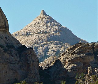
Chimney Rock is a 6,420-foot (1,960 m) summit in Capitol Reef National Park in Wayne County, Utah, United States. This landmark is situated 2.5 mi (4.0 km) northwest of the park's visitor center, towering over 300 feet (91 m) above Utah State Route 24. Chimney Rock is also 2.5 mi (4.0 km) northwest of another of the park's landmarks, The Castle. Precipitation runoff from this feature ends up in the Colorado River drainage basin. The Chimney Rock Trail is a 3.5-mile loop trail that takes hikers to a view of Chimney Rock from above Mummy Cliffs.

Aztec Butte is a sandstone summit, elevation 6,312 feet, located in the Island in the Sky District of Canyonlands National Park, in San Juan County, Utah. Aztec Butte is composed of white cross-bedded Navajo Sandstone, which is the remains of wind-borne sand dunes deposited approximately 170 million years ago during the Jurassic Period. It resembles the Pyramid of the Sun in Mexico, which was built by the Aztecs.

Tabernacle Dome is a 6,430-foot elevation summit located in Zion National Park, in Washington County of southwest Utah, United States. Tabernacle Dome, a formation composed of Navajo Sandstone, is situated at the southeastern end of Cave Valley, 10 mi (16 km) northwest of Springdale, Utah. Its nearest higher neighbor is Cave Knoll, 1.6 mi (3 km) to the north-northwest. Other neighbors include South Guardian Angel, 1.9 mi (3 km) to the east, and North Guardian Angel, 2.2 mi (4 km) to the northeast. Precipitation runoff from this mountain drains into tributaries of the Virgin River. Access to this peak is via the Kolob Terrace Road. This peak's name was officially adopted in 1934 by the U.S. Board on Geographic Names. It is named for its resemblance to the Mormon Tabernacle in Salt Lake City.
Ferns Nipple is a 7,065-foot (2,153-meter) elevation summit located in Capitol Reef National Park, in Wayne County of Utah, United States. This iconic landmark is situated 4 mi (6.4 km) southeast of the park's visitor center. Precipitation runoff from this feature is drained by tributaries of the Fremont River, which in turn is within the Colorado River drainage basin. Folklore attributes this geological feature's naming to outlaw Butch Cassidy and his favored girlfriend named Fern.
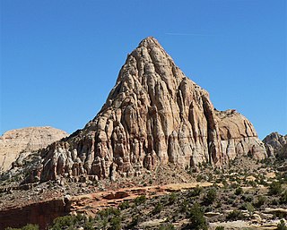
Pectols Pyramid is a 6,211-foot (1,893-meter) elevation summit located in Capitol Reef National Park, in Wayne County of Utah, United States. This iconic landmark is situated 2 mi (3.2 km) southeast of the park's visitor center, 1 mi (1.6 km) south of Navajo Dome, and 0.5 mi (0.80 km) southwest of Capitol Dome. Precipitation runoff from this feature is drained by the Fremont River, which in turn is within the Colorado River drainage basin. This geological feature's name honors Ephraim Portman Pectol (1875–1947), booster and founder of what would become Capitol Reef National Monument in 1937.
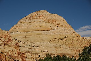
Capitol Dome is a 6,120-foot-elevation (1,870 m) summit located in Capitol Reef National Park, in Wayne County, Utah, United States. This iconic landmark is situated 2.5 miles (4.0 km) east of the park's visitor center, and 0.85 mi (1.37 km) southeast of Navajo Dome. Precipitation runoff from this feature is drained by tributaries of the Fremont River, which in turn is within the Colorado River drainage basin. It towers 800 feet (240 m) above the Fremont River and State Route 24. This geological feature's dome-like shape reminded early explorers and settlers of the dome of the United States Capitol in Washington D.C., and lent the park its name.

Eph Hanks Tower is a 6,540-foot (1,990-meter) elevation summit located in Capitol Reef National Park, in Wayne County of Utah, United States. This landmark is situated 8 mi (13 km) southeast of the park's visitor center, 3.5 mi (5.6 km) south-southeast of Ferns Nipple, and 1.4 mi (2.3 km) south-southwest of Golden Throne, at the mouth of Capitol Gorge where the Capitol Reef Scenic Drive road ends. It towers 900 feet above the picnic area below its north aspect. Precipitation runoff from this feature is drained by Capitol Wash and Pleasant Creek, a tributary of the Fremont River, which in turn is within the Colorado River drainage basin. This geological feature is named after Ephraim Knowlton Hanks (1826–1896), a Mormon pioneer and first permanent settler in the Capitol Reef area, who with his family homesteaded in the Pleasant Creek area of Capitol Reef in 1881. Ephraim Hanks' Floral Ranch on Pleasant Creek supposedly offered a safe retreat for polygamists along the Mormon underground railroad.

Jailhouse Rock is a 6,123-foot (1,866-meter) elevation summit located in Capitol Reef National Park, in Wayne County of Utah, United States. This remote iconic monolith is situated 9 mi (14 km) north of the park's visitor center, and 4 mi (6.4 km) south of Temples of the Sun and Moon, in the South Desert of the park's North District. South Desert is a long, narrow valley that runs parallel to the strike of the Waterpocket Fold monocline. Cathedral Valley was so named in 1945 by Charles Kelly, first superintendent of Capitol Reef National Monument, because the valley's sandstone monoliths reminded early explorers of ornate, Gothic cathedrals, with fluted walls, alcoves, and pinnacles. Jailhouse Rock rises 500 feet above its surrounding terrain, and can be seen from the Lower South Desert Overlook, which is 15 miles northwest of Highway 24 via the Hartnet Road. The hiking approach to the base of this large promontory rising from the valley floor is made from the Lower South Desert Overlook via a switchback trail until it disappears along the valley floor. Precipitation runoff from this feature is drained by Deep Creek, a tributary of the Fremont River, which in turn is within the Colorado River drainage basin.

Temple of the Sun is a 5,822-foot (1,775-meter) elevation summit located in Capitol Reef National Park, in Wayne County of Utah, United States. This remote, iconic monolith is situated 12.5 mi (20.1 km) north-northeast of the park's visitor center, and 0.37 mi (0.60 km) north of Temple of the Moon, in the Middle Desert of the park's North District. Cathedral Valley was so named in 1945 by Charles Kelly, first superintendent of Capitol Reef National Monument, because the valley's sandstone monoliths reminded early explorers of ornate, Gothic cathedrals, with fluted walls, alcoves, and pinnacles. The free-standing Temple of the Sun towers over 400 feet above its surrounding terrain, which is within the Fremont River drainage basin. John C. Frémont's 1853 expedition passed through Cathedral Valley.

Temple of the Moon is a 5,665-foot (1,727-meter) elevation summit located in Capitol Reef National Park, in Wayne County of Utah, United States. This remote, iconic monolith is situated 12 mi (19 km) north-northeast of the park's visitor center, and 0.37 mi (0.60 km) south of Temple of the Sun, in the Middle Desert of the park's North District. Cathedral Valley was so named in 1945 by Charles Kelly, first superintendent of Capitol Reef National Monument, because the valley's sandstone monoliths reminded early explorers of ornate, Gothic cathedrals, with fluted walls, alcoves, and pinnacles. The free-standing Temple of the Moon towers nearly 300 feet above its surrounding terrain, which is within the Fremont River drainage basin. John C. Frémont's 1853 expedition passed through Cathedral Valley.
Needle Mountain is a 6,620-foot (2,020-meter) elevation summit located in Capitol Reef National Park, in Wayne County of Utah, United States. This remote erosional remnant is situated 16 miles (26 km) north-northwest of the park's visitor center, and 0.6 miles (0.97 km) east of Cathedral Mountain, in the Middle Desert of the park's North District. Cathedral Valley was so named in 1945 by Charles Kelly, first superintendent of Capitol Reef National Monument, because the valley's sandstone monoliths reminded early explorers of ornate, Gothic cathedrals, with fluted walls, alcoves, and pinnacles. The free-standing Needle Mountain towers 240 feet above its surrounding terrain, which is within the Fremont River drainage basin. John C. Frémont's 1853 expedition passed through Cathedral Valley.

Cathedral Mountain is a 6,924-foot (2,110 m) summit located in Capitol Reef National Park, in Wayne County of Utah, United States.

Hickman Natural Bridge is a 125-foot-tall natural bridge located in Capitol Reef National Park, Wayne County, Utah, United States. The formation spans 133 feet, making it one of the largest rock spans in the park.


