Acklington Park is a former civil parish, now in the parish of Acklington, Northumberland, England. It was the birthplace of John Rushworth who achieved fame in both England and during the formation of the United States of America for compiling a series of works called Historical Collections covering the English Civil Wars throughout the 17th century. His writings became a part of the library of Thomas Jefferson and the second Library of Congress. In 1951 the parish had a population of 33.
Birling is a small settlement and former civil parish, now in the parish of Warkworth, in the county of Northumberland, England. It is situated immediately to the north of the village of Warkworth on the A1068, separated from Warkworth by the River Coquet. There are facilities for static and touring caravans at Birling. To the east are Warkworth Golf Club, Birling Links and beach. In 1951 the parish had a population of 81.

Beanley is a village and former civil parish, now in the parish of Hedgeley in the county of Northumberland, England. It is situated to the north-west of Alnwick, near Eglingham. In 1951 the parish had a population of 53.

Bebside is a village and former civil parish, now in the parish of Blyth, in Northumberland, in England. It is situated to the west of Blyth. It was formerly a mining village, the mine associated with the village operated between 1858 and 1926. It was served by Bebside railway station, from 1850 to 1964. In 1911 the parish had a population of 58.

Berwick Hill is a village and former civil parish, now in the parish of Ponteland, in the county of Northumberland, England. It is situated to the north of Newcastle upon Tyne, near Ponteland. In 1951 the parish had a population of 41.

Burradon is a village and former civil parish, now in the parish of Netherton, in Northumberland, England. It is about 14 miles (23 km) to the south-west of Alnwick. In 1951 the parish had a population of 53.

Branton is a village and former civil parish, now in the parish of Ingram, in Northumberland, England. It is about 9 miles (14 km) west of Alnwick. In 1951 the parish had a population of 50.
Brunton is a village and former civil parish, now in the parish of Newton-by-the-Sea, in the county of Northumberland, England. It is about 7 miles (11 km) north of Alnwick, a short distance inland from the North Sea coast. In 1951 the parish had a population of 35.

Cambo is a village and former civil parish, now in the parish of Wallington Demesne, in Northumberland, England. It is about 11 miles (18 km) to the west of the county town of Morpeth at the junction of the B6342 and B6343 roads. The village was gifted along with the Wallington Estate to the National Trust by Sir Charles Philips Trevelyan in 1942, the first donation of its kind. It remains a National Trust village. In 1951 the parish had a population of 60.
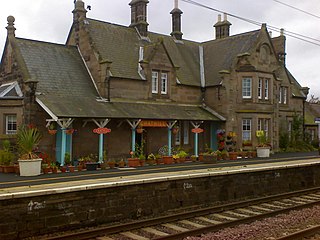
Chathill is a hamlet and former civil parish, now in the parish of Ellingham, in Northumberland, England. It is about 9 miles (14 km) north of Alnwick and 3 miles (5 km) inland from the North Sea coast. It is served by Chathill railway station. It is on the main road serving Seahouses and the northern coast. In 1951 the parish had a population of 59.
Clennell is a small village and as Clennel, a former civil parish, now in the parish of Alwinton, in Northumberland, England. It is about 1 mile (1.6 km) north-east of Alwinton. In 1951 the parish had a population of 37.
Cowpen is an area of Blyth and former civil parish, now in the parish of Blyth in the county of Northumberland, England. It is just east of the A189 road. The Ward population taken at the 2011 census was 4,466. In 1911 the parish had a population of 21,295.
Bassington is a former civil parish, now in the parish of Eglingham, in the county of Northumberland, England. It is located about 3 miles (5 km) northwest of Alnwick. Bassington is traversed by the River Aln. In 1951 the parish had a population of 2.

Sharperton is a small settlement and former civil parish, now in the parish of Harbottle, in Northumberland, England. Sharperton is the site of a deserted medieval village, which was documented as having 14 taxpayers in 1296, and described as having two short rows of dwellings in 1632. There was also a bastle here. In 1951 the parish had a population of 36.

Stanton is a small hamlet and former civil parish, now in the parish of Netherwitton, in Northumberland, England, which is located 7 miles (11 km) north west of Morpeth, and 15 miles (24 km) north of Newcastle upon Tyne. Stanton is 9 miles (14 km) from the Northumberland National Park (NNPA). In 1951 the parish had a population of 70.

Broxfield is a hamlet and former civil parish, now in the parish of Rennington, in the county of Northumberland, England, off the B1340. In 1951 the parish had a population of 18.

Halton is a village and former civil parish, now in the parish of Whittington, in the southern part of Northumberland, England. It is situated 3 miles (4.8 km) north of Corbridge just south of Hadrian's Wall. In 1951 the parish had a population of 24.
Ouston is a village and former civil parish, now in the parish of Stamfordham, in the county of Northumberland, England. In 1951 the parish had a population of 13.
Cooklaw is a small settlement and a former civil parish, now in the parish of Wall, in Northumberland, England. It is near the A6079 road and the River North Tyne. In 1951 the parish had a population of 119.

South Charlton is a small village and former civil parish, now in the parish of Eglingham, in the county of Northumberland, England, five miles (8 km) north-west of Alnwick. In 1951 the parish had a population of 82.

