Churchill County is a county in the western U.S. state of Nevada. As of the 2020 census, the population was 25,516. Its county seat is Fallon. Named for Mexican–American War hero brevet Brigadier General Sylvester Churchill, the county was formed in 1861. Churchill County comprises the Fallon, NV Micropolitan Statistical Area. It is in northwestern Nevada. Churchill County is noteworthy in that it owns and operates the local telephone carrier, Churchill County Communications.

Highland Township, officially the Charter Township of Highland, is a charter township of west Oakland County, Michigan. The population was 19,202 at the time of the 2010 census.

Signy Island is a small subantarctic island in the South Orkney Islands of Antarctica. It was named by the Norwegian whaler Petter Sørlle (1884–1933) after his wife, Signy Therese.

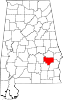
Inverness is an unincorporated community in Bullock County in the U.S. state of Alabama.

Brownsville is an unincorporated community and census-designated place (CDP) in northeastern Bowling Green Township, Licking County, Ohio, United States. As of the 2020 census, it had a population of 214. It lies at the intersection of U.S. Route 40 with State Route 668.

Fitzpatrick is an unincorporated community and census-designated place in Bullock County, Alabama, United States. It first appeared as a CDP in the 2010 census with a population of 83. The community is served by Alabama State Route 110.

Flintstone is an unincorporated community in Walker County, Georgia, United States. Located in northwestern Georgia, Flintstone lies approximately 12 miles south of Chattanooga, Tennessee, 120 miles northwest of Atlanta, 135 miles southeast of Nashville, Tennessee, and 150 miles northeast of Birmingham, Alabama. Although Flintstone is unincorporated, it has a post office, with the ZIP code of 30725; the ZCTA for ZIP Code 30725 had a population of 3,456 at the 2000 census.

Snake Mountain is a mountain located along the border of North Carolina and Tennessee, east of the community of Zionville, in the southeastern United States. It is part of the Blue Ridge Mountains, and includes parts of Watauga County, North Carolina, and Johnson County, Tennessee. It has two peaks, the higher of which reaches an elevation of 5,564 feet (1,696 m). The lower peak, at 5,518 feet (1,682 m), is Johnson County's high point.
Remlap is a census-designated place in Blount County, Alabama, United States, located along Alabama State Route 75, 11.7 miles (18.8 km) southwest of Oneonta. Remlap has a post office with ZIP code 35133.
Pea Ridge is a census-designated place in Shelby County, Alabama, United States. The community is named for Pea Ridge, the broadest ridge in the Cahaba Coal Field. This ridge divides the waters of the Cahaba River and Little Cahaba River. Pea Ridge has maintained a volunteer fire department since 1972.
Thompson, also known as Thompson Station, is an unincorporated community in Bullock County, Alabama, United States.
Blues Old Stand is an unincorporated community in Bullock County, Alabama, United States. The main road through the community is U.S. Route 29 in Alabama, but also includes Bullock County Roads 14 and 19. Blue Old Stand serves as the home of the Master Rack Hunting Lodge.
Orion, also known as Prospect Ridge, is an unincorporated community in Pike County, Alabama, United States, located 12.9 miles (20.8 km) north of Troy.
Aberfoil is an unincorporated community in Bullock County, in the U.S. state of Alabama. The main roads through the community are U.S. Route 29 and Alabama State Route 239.
Hightogy, also known as Ridge Beat or Simmon Town, is an unincorporated community in Lamar County, Alabama, United States. Hightogy is located along Alabama State Route 17, 4.8 miles (7.7 km) south-southeast of Vernon.
New Hope is an unincorporated community in the southeast corner of Franklin Township, Owen County, in the U.S. state of Indiana. It lies near the intersection of County Road 740 South and County Road 285 West, which is a community about nine miles southwest of the city of Spencer, the county seat. Its elevation is 522 feet, and it is located at 39°10′59″N86°49′40″W.
Bullocktown is an unincorporated community in Boon Township, Warrick County, in the U.S. state of Indiana.
Burnsville, also known as Byrnville, is an unincorporated community in Dallas County, Alabama.
Scottland is an unincorporated community in Bullock County, Alabama, United States.
Poplar Ridge is an unincorporated community in Madison County, Alabama, United States.