Midway, Alabama | |
---|---|
Town | |
Coordinates: 32°4′28″N85°31′13″W / 32.07444°N 85.52028°W | |
Country | United States |
State | Alabama |
County | Bullock |
Area | |
• Total | 3.31 sq mi (8.57 km2) |
• Land | 3.31 sq mi (8.57 km2) |
• Water | 0.00 sq mi (0.00 km2) |
Elevation | 538 ft (164 m) |
Population (2020) | |
• Total | 421 |
• Density | 127.23/sq mi (49.12/km2) |
Time zone | UTC-6 (Central (CST)) |
• Summer (DST) | UTC-5 (CDT) |
FIPS code | 01-48424 |
GNIS feature ID | 0122703 |
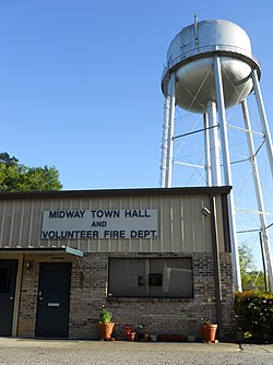
Midway is a town located in eastern Bullock County, Alabama, United States. At the 2020 census, the population was 421.
Margaret Elizabeth Merritt of Midway sold two acres for $5 to the State of Alabama in 1921 as a site for an elementary school for African-American children. Built in 1922 with matching Rosenwald funds, the Midway Colored Public School featured oak and pine construction and two classrooms divided by a partition. The building is one of the few surviving of the more than 5,000 rural black schools built with contributions for the Julius Rosenwald Fund. The building was enlarged twice then renovated in 1978. It is now used as a community center. It was added to the Alabama Register of Landmarks and Heritage on November 2, 1990, and the National Register of Historic Places on February 20, 1998. [2]
The school is located in Bullock County. Bullock has the highest illiteracy rate of any county in Alabama.
Midway is located in eastern Bullock County at 32°4'27.854" North, 85°31'12.857" West (32.074404, −85.520238). [3]
According to the U.S. Census Bureau, the town has a total area of 1.6 square miles (4.1 km2), all land.
Midway is located on the U.S. Route 82, the Jefferson Davis Highway, 13 miles (21 km) east of Union Springs, the county seat. It is 27 miles (43 km) east to Eufaula via US-82. Alabama State Route 51 leads south 16 miles (26 km) to Clayton.
Census | Pop. | Note | %± |
---|---|---|---|
1880 | 450 | — | |
1890 | 612 | 36.0% | |
1900 | 430 | −29.7% | |
1910 | 464 | 7.9% | |
1920 | 524 | 12.9% | |
1930 | 710 | 35.5% | |
1940 | 617 | −13.1% | |
1950 | 544 | −11.8% | |
1960 | 594 | 9.2% | |
1970 | 558 | −6.1% | |
1980 | 593 | 6.3% | |
1990 | 455 | −23.3% | |
2000 | 457 | 0.4% | |
2010 | 499 | 9.2% | |
2020 | 421 | −15.6% | |
U.S. Decennial Census [4] 2013 Estimate [5] |
Race / Ethnicity | Pop 2010 [6] | Pop 2020 [7] | % 2010 | % 2020 |
---|---|---|---|---|
White alone (NH) | 53 | 18 | 10.62% | 4.28% |
Black or African American alone (NH) | 441 | 394 | 88.38% | 93.59% |
Native American or Alaska Native alone (NH) | 0 | 0 | 0.00% | 0.00% |
Asian alone (NH) | 0 | 0 | 0.00% | 0.00% |
Pacific Islander alone (NH) | 0 | 0 | 0.00% | 0.00% |
Some Other Race alone (NH) | 0 | 1 | 0.00% | 0.24% |
Mixed Race/Multi-Racial (NH) | 2 | 4 | 0.40% | 0.95% |
Hispanic or Latino (any race) | 3 | 4 | 0.60% | 0.95% |
Total | 499 | 421 | 100.00% | 100.00% |
As of the census [8] of 2000, there were 457 people, 189 households, and 124 families residing in the town. The population density was 290.3 inhabitants per square mile (112.1/km2). There were 230 housing units at an average density of 146.1 per square mile (56.4/km2). The racial makeup of the town was 88.84% Black or African American and 11.16% White. 0.22% of the population were Hispanic or Latino of any race.
There were 189 households, out of which 34.4% had children under the age of 18 living with them, 26.5% were married couples living together, 37.0% had a female householder with no husband present, and 33.9% were non-families. 31.7% of all households were made up of individuals, and 12.7% had someone living alone who was 65 years of age or older. The average household size was 2.42 and the average family size was 3.06.
In the town, the age distribution of the population shows 29.8% under the age of 18, 9.6% from 18 to 24, 23.4% from 25 to 44, 21.9% from 45 to 64, and 15.3% who were 65 years of age or older. The median age was 35 years. For every 100 females, there were 71.2 males. For every 100 females age 18 and over, there were 63.8 males.
The median income for a household in the town was $12,143, and the median income for a family was $19,063. Males had a median income of $25,938 versus $18,750 for females. The per capita income for the town was $9,036. About 38.1% of families and 42.5% of the population were below the poverty line, including 52.4% of those under age 18 and 45.0% of those age 65 or over.
Bullock County is a county of the U.S. state of Alabama. As of the 2020 census, the population was 10,357. Union Springs was chosen as the county seat in 1867, and presently is the county's only incorporated city. The county was named for Confederate Army Colonel Edward C. Bullock who was a state senator and outspoken secessionist who died during the American Civil War.
Chambers County is a county located in the east central portion of the U.S. state of Alabama. As of the 2020 census the population was 34,772. Its county seat is LaFayette. Its largest city is Valley. Its name is in honor of Henry H. Chambers, who served as a United States Senator from Alabama.
Cleburne County is a county located in the east central portion of the U.S. state of Alabama. As of the 2020 census, the population was 15,056. Its county seat is Heflin. Its name is in honor of Patrick R. Cleburne of Arkansas who rose to the rank of major general in the Confederate States Army. The eastern side of the county borders the state of Georgia.
Coosa County is located in the east central portion of the U.S. state of Alabama. As of the 2020 census the population was 10,387. Its county seat is Rockford. Its name derives from a town of the Creek tribe and the Coosa River, which forms one of the county borders.
Macon County is a county located in the east central part of the U.S. state of Alabama. As of the 2020 census, the population was 19,532. Its county seat is Tuskegee. Its name is in honor of Nathaniel Macon, a member of the United States Senate from North Carolina.
Pike County is located in the U.S. state of Alabama. As of the 2020 census the population was 33,009. Its county seat is Troy. Its name is in honor of General Zebulon Pike, of New Jersey, who led an expedition to southern Colorado and encountered Pikes Peak in 1806.
Tallapoosa County is located in the east-central portion of the U.S. state of Alabama. As of the 2020 census, the population was 41,311. Its county seat is Dadeville. Its largest city is Alexander City.
Selmont-West Selmont is a census-designated place (CDP) in Dallas County, Alabama, United States. At the 2020 census, the population was 2,158.
Ridgeville is a town in Etowah County, Alabama, United States. It incorporated in 1969 and is part of the Gadsden Metropolitan Statistical Area. At the 2020 census the population was 83, down from 158 in 2000. It is noteworthy for being the only community in Etowah County to have a black majority. Since 1970, it has also been the least populated community wholly within the county.
Forkland is a town in Greene County, Alabama, United States. At the 2020 census, the population was 445. It was incorporated around 1974.
Akron is a town in Hale County, Alabama, United States. In 1906, the owner of a large plantation, Waller Evan Wedgworth, sold part of his land to developers, and a construction boom followed. The town was incorporated in March 1918. At the 2010 census the population was 356, down from 521 at the 2000 census. Akron has one site on the National Register of Historic Places, the Greek Revival cottage known as Tanglewood.
North Courtland is a town in Lawrence County, Alabama, United States, and is included in the Decatur Metropolitan Area, as well as the Huntsville-Decatur Combined Statistical Area. It incorporated in 1981. At the 2010 census, the population of the town was 632, down from 799 in 2000. Along with Hillsboro, it is one of two majority black communities in Lawrence County out of its six populated communities as of 2010.
Loachapoka is a town in Lee County, Alabama, United States. It is located less than 1/2 mile west of Auburn and approximately 5 miles (8 km) west of Auburn University, in west-central Lee County. The population was 180 as of the 2010 census. It is part of the Auburn metropolitan area.
Gordonville is a town in Lowndes County, Alabama, United States. At the 2010 census the population was 326, up from 318 in 2000. It is part of the Montgomery Metropolitan Statistical Area. It incorporated effective January 20, 1990.
Mosses is a town in Lowndes County, Alabama, United States. At the 2010 census the population was 1,029, down from 1,101 in 2000. It is part of the Montgomery Metropolitan Statistical Area. It incorporated in 1979.
White Hall is a town in Lowndes County, Alabama, United States. The community was named for a plantation that was destroyed in an 1882 tornado. At the 2010 census the population was 858, down from its record high of 1,014 in 2000. It is part of the Montgomery Metropolitan Statistical Area.
Shorter is a town in Macon County, Alabama, United States. At the 2020 census the population was 385, down from 474 at the 2010 census. According to the 1990 U.S. Census records, it was incorporated in 1984.
Oak Hill is a town in Wilcox County, Alabama, United States. According to the 1940 U.S. Census, it incorporated in 1938. Per the 2020 census, the population was 14. It is the smallest incorporated town in Alabama as of 2020, succeeding McMullen. The smallest unincorporated census-designated place in the state is also located in Wilcox County, that of Catherine, which had 22 residents as of 2010. With a median household income of $9,286, Oak Hill is the poorest community in Alabama.
Pine Apple is a town in Wilcox County, Alabama, United States. It incorporated in 1872. Per the 2020 census, the population was 143. It has two places on the National Register of Historic Places, the Hawthorne House and the Pine Apple Historic District.
Esto is a town in Holmes County, Florida, United States. The Town of Esto is located on the Florida Panhandle in North Florida. The population was 341 at the 2020 census.
Media related to Midway, Alabama at Wikimedia Commons