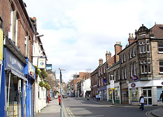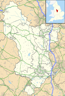
Belper is a town and civil parish in the local government district of Amber Valley in Derbyshire, England, located about 7 miles (11 km) north of Derby on the River Derwent. As well as Belper itself, the parish also includes the village of Milford and the hamlets of Bargate, Blackbrook and Makeney. As of the 2011 Census, the parish had a population of 21,823. Originally a centre for the nail-making industry since Medieval times, Belper expanded during the early Industrial Revolution to become one of the first mill towns with the establishment of several textile mills; as such, it forms part of the Derwent Valley Mills World Heritage Site.

New Mills is a town in Derbyshire, England. It is approximately 8 miles (13 km) south-east of Stockport and 13 miles (21 km) from Manchester, at the confluence of the rivers Goyt and Sett, close to the border of Cheshire. The town stands above the Torrs, a 70 feet (21 m) deep gorge, cut through Woodhead Hill Sandstone of the Carboniferous period. It is on the north-western edge of the Peak District, England's first national park.

Wales is a village and a civil parish in the Metropolitan Borough of Rotherham in South Yorkshire, England. Historically part of the West Riding of Yorkshire it borders, to the south, Derbyshire and is astride the M1 motorway. The civil parish of Wales, which has a population of 6,455, increasing to 7,069 at the 2011 Census, encompasses the village and neighbouring settlement Kiveton Park.

Hutton Magna is a village and civil parish in County Durham, England. Situated 7.6 miles (12.2 km) south east of Barnard Castle. Lying within the historic boundaries of the North Riding of Yorkshire, the village along with the rest of the former Startforth Rural District has been administered with County Durham since 1 April 1974, under the provisions of the Local Government Act 1972. The civil parish also includes the hamlet of Lane Head.

Hackenthorpe is a village 5 miles south east of Sheffield’s city centre, now classed as a historic township of the city. Due to much expansion, the village became a part of Sheffield city during the 1950s. During much of the late 19th and 20th centuries the village was noted for its steelmaking, with the Thomas Staniforth & Co Sickle works being based at Main Street. Another prominent feature of the village is the 17th century Hackenthorpe Hall, built by John Newbould for the Hounsfield family, with James Hounsfield being a prominent land owner. The building is today used as a nursery.

Birley ward — which includes the districts of Base Green, Birley Estate, Charnock, Frecheville, Scowerdons and part of Hackenthorpe — is one of the 28 electoral wards in City of Sheffield, England. It is located in the southeastern part of the city and covers an area of 5.1 km2. The population of this ward in 2011 was 16,943 people in 7,393 households. It is one of the five wards that make up the Sheffield South East constituency.

Marske is a village and civil parish in the Richmondshire district of North Yorkshire, England, situated in lower Swaledale on the boundary of the Yorkshire Dales National Park, the village is approximately 5 miles west of Richmond. According to the UK 2011 Census, the population of the parish of Marske, including New Forest was 127. The parish includes the hamlets of Applegarth, Clints, Feldom and Skelton.

Ockbrook is a village in Derbyshire, England. It is almost contiguous with the village of Borrowash, the two only separated by the A52. The civil parish is Ockbrook and Borrowash. The population of this civil parish at the 2011 Census was 7,335. Ockbrook lies about 5 miles (8.0 km) east of Derby.

Ridgeway is a village in the North East Derbyshire in the county of Derbyshire in England.

Hutton Bonville is a hamlet and civil parish in the Hambleton District of North Yorkshire, England. The population of the civil parish as of the 2011 census was less than 100. Details are included in the civil parish of Danby Wiske with Lazenby. On its own road and near the A167, 6 miles (9.7 km) north of Northallerton.

Hutton is a village and civil parish in Somerset, England. The parish, which has a population of 2,582, is within the unitary authority of North Somerset and located on the western edge of the Mendip Hills, close to Weston-super-Mare.

Long Marston is a village and civil parish in the Harrogate district of North Yorkshire, England. Historically part of the West Riding of Yorkshire, it is situated on the B1224 road from Wetherby to York, 7 miles (11 km) west of York. The civil parish includes the hamlets of Hutton Wandesley, immediately south of the village of Long Marston, and Angram, 1.5 miles (2.4 km) south east of Hutton Wandesley.

Eastburn is a hamlet in the East Riding of Yorkshire, England, it forms part of the civil parish of Kirkburn. It is situated in the Yorkshire Wolds on the A164 road, approximately 2.5 miles (4 km) south-west of Driffield town centre and 3 miles (5 km) north-west of the village of Hutton Cranswick.

Overseal is a village and civil parish in South Derbyshire, 3 miles (4.8 km) south of Swadlincote, 4.5 miles (7.2 km) west of Ashby-de-la-Zouch and 12.5 miles (20.1 km) due south-southwest of Derby. The population of the civil parish at the 2011 census was 2,450. Situated within the National Forest area, it is one of the southernmost settlements in Derbyshire, close to the border with Leicestershire.

Sutton cum Duckmanton is a civil parish in Derbyshire, England, between Bolsover and Chesterfield in the district of North East Derbyshire.

Troway is a village in North East Derbyshire, England. Population details are included in the civil parish of Eckington.

Mosborough is a village 7 miles south east of Sheffield’s city centre, now classed as a historic township of the city. The town was named after The Moss river that flows through the area. Due to much expansion, the village became a part of Sheffield city in 1967. During much of the late 19th and 20th centuries the village was noted for its steelmaking, with Hutton & Co. Sickle works being based at nearby Ridgeway.

Plumbley is a hamlet in the City of Sheffield borough, within the county of South Yorkshire in England.

Normanton Spring, also called Normanton Springs, is a suburb and former hamlet located 4 miles east of Sheffield's City Centre, now classed as a historic township of the city. Due to expansion during the 1960s, the hamlet became a part of Sheffield City.

Nether Handley is a hamlet in North East Derbyshire in the county of Derbyshire in England.


