Highway H16 (Ukraine)

Last updated
N-road-16-Ukraine.svg
Highway H16
Автошлях Н16
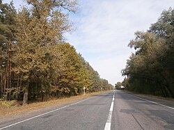
Zolotonis'kyi district, Cherkas'ka oblast, Ukraine - panoramio (679).jpg
Route information
Length217 km (135 mi)
Major junctions
East endN-road-08-Ukraine.svg H 08 in Zolotonosha
West endM12-UA.svg M 12 in Uman
Location
Country Ukraine
Oblasts Cherkasy
Highway system
N-road-15-Ukraine.svg H 15 N-road-17-Ukraine.svg H 17

H16 is a national road (H-Highway) in Cherkasy Oblast, Ukraine.

It starts at the roundabout in H08, at the beginning of the Zolotonosha bypass road, on the outskirts of the village of Zhar, goes south to the Kremenchuk Reservoir, crosses it with the Cherkasy Dam. Then it passes through the cities of Cherkasy, Smila, Shpola, Zvenyhorodka, Talne and ends at the roundabout with the M12 near Uman. [1]

The total length of H16 is listed by the State Agency of Automobile Roads of Ukraine at 217 km (135 mi). [2]

See also

Related Research Articles

<span class="mw-page-title-main">Roundabout</span> Traffic intersection

A roundabout, a rotary and a traffic circle are types of circular intersection or junction in which road traffic is permitted to flow in one direction around a central island, and priority is typically given to traffic already in the junction.

<span class="mw-page-title-main">Capricorn Highway</span> Highway in Queensland, Australia

The Capricorn Highway is located in Central Queensland, Australia, and links the city of Rockhampton with western Queensland. The highway is 575 kilometres (357 mi) long, and joins the Landsborough Highway at Barcaldine. Formerly National Route 66, Queensland began to convert to the alphanumeric system much of Australia had adopted in the early-2000s and is now designated as A4. The highway runs parallel with the Tropic of Capricorn, hence its name.

<span class="mw-page-title-main">U.S. Route 224</span> U.S. Numbered Highway in Indiana, Ohio, and Pennsylvania in the United States

U.S. Route 224 (US 224) is a spur of US 24 that runs through the states of Indiana, Ohio and Pennsylvania. It currently runs for 289 miles (465 km) from US 24 in Huntington, Indiana, east to US 422 Business and Pennsylvania Route 18 (PA 18) in New Castle, Pennsylvania. It goes through the cities of Canfield, Ohio, Akron, Ohio, and Findlay, Ohio. In Northeast Ohio, US 224 is located a short distance north of the Western Reserve's southern boundary.

<span class="mw-page-title-main">Cherkasy</span> City in Ukraine

Cherkasy is a city in central Ukraine. Cherkasy serves as the administrative centre of Cherkasy Oblast as well as Cherkasy Raion within the oblast. The city has a population of 269,836.

<span class="mw-page-title-main">Captain Cook Highway</span> Highway in Queensland, Australia

The Captain Cook Highway is a short, regional highway in Queensland that originates in Cairns and terminates in Mossman, where it joins Mossman-Daintree Road, continuing to Daintree. It is a state-controlled regional road.

Melba Highway is a semi-rural highway that connects the outer eastern suburbs of Melbourne to the town of Yea, in Victoria's Upper Goulburn region. It is named after Dame Nellie Melba, a famed Australian opera singer of the early 20th century, whose former country estate lies at the southern end of the highway in Coldstream.

<span class="mw-page-title-main">East Derwent Highway</span> Highway in Hobart, Tasmania, Australia

The East Derwent Highway is a highway in Hobart, Tasmania, Australia. The highway is a trunk road that carries heavy commuter traffic, much like the Brooker Highway, on the eastern side of the River Derwent.

<span class="mw-page-title-main">Washington State Route 531</span> Highway in Washington

State Route 531 (SR 531) is a short state highway in Snohomish County, Washington, United States. It runs from west to east along 172nd Street between Wenberg County Park on Lake Goodwin to a junction with SR 9 in southern Arlington, with an intermediate interchange with Interstate 5 (I-5) in Smokey Point. The highway is the primary access point for the Arlington Municipal Airport and the Smokey Point retail corridor.

<span class="mw-page-title-main">Washington State Route 702</span> Highway in Washington

State Route 702 is a 9.32-mile (15.00 km) long two-lane state highway located entirely in Pierce County, Washington, United States. The highway travels through rural Pierce County, and has existed since at least 1931 as State Highway 10, then as Secondary State Highway 5J until the 1964 state highway renumbering when it was renumbered to SR 702. The roadway the highway is routed along, continues east to an interchange with SR 161.

<span class="mw-page-title-main">Washington State Route 224</span> State highway in Benton County, Washington, US

State Route 224 (SR 224) is a 10.15-mile (16.33 km) long state highway located entirely in Benton County, Washington, United States. The highway serves to connect SR 225 to Interstate 82 (I-82) and U.S. Route 12 (US 12), and to link Benton City to West Richland and Richland. Before the 1964 state highway renumbering the highway was numbered Secondary State Highway 3R. SR 224 is a lightly traveled rural highway except through Richland, where an average of 16,000 cars traveled the highway daily in 2009. The Washington State Department of Transportation (WSDOT) rebuilt its southern terminus as a roundabout in 2016, as part of a project to improve traffic congestion near the Red Mountain AVA.

<span class="mw-page-title-main">Washington State Route 292</span> State highway in Stevens County, Washington, US

State Route 292 (SR 292) is a state highway located entirely in Stevens County, Washington, United States. The east–west highway connects SR 231 in Springdale to U.S. Route 395 (US 395) at Loon Lake. It is approximately 6 miles (9.7 km) long and follows Sheep Creek and a railroad.

<span class="mw-page-title-main">Maryland Route 94</span> State highway in Howard County, Maryland, US, known as Woodbine Rd

Maryland Route 94 is a state highway in the U.S. state of Maryland. Known as Woodbine Road, the state highway runs 6.25 miles (10.06 km) from the Montgomery–Howard county line at the Patuxent River north to Old Frederick Road near Lisbon. MD 94 originally extended into southern Carroll County in addition to connecting the western Howard County communities of Lisbon and Florence. The state highway was constructed from Lisbon to Woodbine in the late 1910s. MD 94 was constructed from Lisbon south through Florence and from Woodbine north to the village of Daniel south of MD 26 in the late 1920s and early 1930s. The state highway was extended south and removed from the state highway system north of Lisbon in 1956. MD 94 was relocated when its interchange with Interstate 70 (I-70)/U.S. Route 40 was built in the mid-1970s. The state highway has two roundabouts, one of which was the first modern roundabout in Maryland.

<span class="mw-page-title-main">Maryland Route 387</span> State highway in Maryland, United States

Maryland Route 387 is a state highway in the U.S. state of Maryland. Known as Spa Road, the highway runs 1.68 miles (2.70 km) from the beginning of state maintenance near Ferry Point Road north to MD 450 and MD 435 in Annapolis. MD 387 was constructed in the late 1920s. Much of the highway was transferred from state to municipal maintenance in the mid-1970s.

<span class="mw-page-title-main">Highway H01 (Ukraine)</span> Highway in Ukraine

Highway H01 is a Ukrainian national highway (H-highway) connecting the capital of Ukraine Kyiv with the central regions. It runs through Kyiv, Kyiv Oblast, Cherkasy Oblast, and ends in Kirovohrad Oblast.

<span class="mw-page-title-main">Irdynivka</span> Rural settlement in Cherkasy Oblast, Ukraine

Irdynivka is a rural settlement in Cherkasy Raion of Cherkasy Oblast (province) in central Ukraine. It belongs to Bilozirya rural hromada, one of the hromadas of Ukraine. The settlement consists of only a small number of buildings and streets, and as of 2001 the population totalled 39 residents.

The M21 highway was a road in Moldova, which linked Chișinău to the border with Ukraine near Dubău via Dubăsari. It was 60 km (37 mi) long, and formed part of the European route E584 of the International E-road network. Furthermore, it also shared a small segment with the E58 and E581 north-west of Chișinău.

<span class="mw-page-title-main">Highway H08 (Ukraine)</span> Highway in Ukraine

H08 is an important Ukraine national highway (H-highway) in Kyiv, Cherkasy, Poltava, Kirovohrad, Dnipropetrovsk, Zaporizhzhia and Donetsk Oblasts.

Rockhampton–Yeppoon Road is a non-continuous 39.8 kilometres (24.7 mi) road route in the Rockhampton and Livingstone local government areas of Queensland, Australia. Most of the route is designated as State Route 4 (Regional) and Tourist Drive 10. It is a state-controlled regional road.

Caloundra Road is a continuous 9.3-kilometre (5.8 mi) road route in the Sunshine Coast local government area of Queensland, Australia. Most of it is designated as part of State Route 6. It is a state-controlled district road, part of which is rated as a local road of regional significance (LRRS).

Kilcoy–Beerwah Road is a continuous 30.4-kilometre (18.9 mi) road route in the Moreton Bay and Sunshine Coast local government areas of Queensland, Australia. It is designated as part of State Route 6. It is a state-controlled regional road. It is part of a route that carries tourist traffic from the New England Highway to the Bruce Highway.

References

  1. Google (May 1, 2022). "Overview route of Highway H16" (Map). Google Maps . Google. Retrieved May 1, 2022.
  2. "H-16 Золотоноша – Черкаси – Сміла – Умань". Archived from the original on 2021-08-11. Retrieved 2022-05-01.