Sumy is a city in northeastern Ukraine. It serves as the administrative center of Sumy Oblast. The city is situated on the banks of the Psel River with a population of 256,474, making it the 23rd-largest in the country.

Bilopillia is a city in Sumy Raion of Sumy Oblast of northeastern Ukraine. It was the administrative center of Bilopillia Raion until it was abolished on 18 July 2020. It is located close to Kursk Oblast of Russia. Population: 15,600 The city's ancient name is Vyr.
State highways in Ukraine are subdivided into three categories: international (M-network), national (H-network), and regional (P-network). The letter's indexes are in Cyrillic, standing for their respective abbreviations in Ukrainian.

Highway M02 is a Ukraine international highway (M-highway) connecting the M01 near Kipti with Bachivsk on the border with Russia, where it continues as the M3 to Moscow. The entire route is part of European route E101 and the section from Hlukhiv to the Russian border is part of European route E391.

Kharkiv Governorate was a governorate of Ukraine from 1918 to 1925.

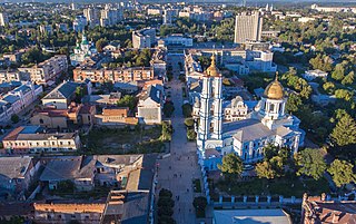
Sumska Street (Ukrainian: Сумська, Sums'ka) is the main street of Kharkiv, Ukraine. It stretches through the centre of the city from the Constitution Square to Bilhorodske shose. The street also serves as an administrative line between Kyivskyi and Shevchenkivskyi district of Kharkiv city.
Krasnokutsk is an urban-type settlement in Bohodukhiv Raion, Kharkiv Oblast, Ukraine. It hosts the administration of Krasnokutsk settlement hromada, one of the hromadas of Ukraine. Population: 7,164.
Velyka Pysarivka is an urban-type settlement in Sumy Oblast, northeastern Ukraine. It was formerly the administrative center of Velyka Pysarivka Raion, but is now administered within Okhtyrka Raion. It is located close to the border with Russia, on the left bank of the Vorskla, a tributary of the Dnieper. Population: 3,928.
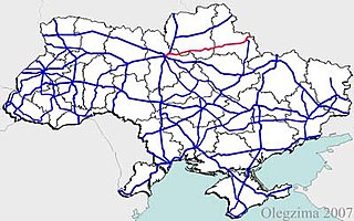
H12 is an important Ukraine national highway (H-highway) in Sumy and Poltava Oblasts, Ukraine, running mainly north–south, and connecting Sumy with Poltava in a more or less straight line. It begins in Sumy at Bandera Street and Illinska Street, and travels straight through central Sumy. It passes through Syrovatka, Boromlya, Trostyanets, Klymentove, Okhtyrka, Khukhra, Kotelva, Velyki Budyshcha, and Dykanka, and then loops around Poltava and terminates at the intersection of Highway M03 and Polovky Street.
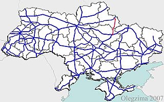
H07 is an important Ukraine national highway (H-highway) in Kyiv, Chernihiv, and Sumy Oblasts, Ukraine, running mainly west-east, and connecting Kyiv with Yunakivka in a more or less straight line. It begins in Brovary at Highway M01/Highway E95, and passes through Krasylivka, Hoholiv, Rusaniv, Peremoha, Nova Basan, Novyi Bykiv, Pohreby, Rudivka, Pryluky, Okhyrky, Sribne, Kharkove, Lavirkove, Romny, Korovyntsi, Nedryhailiv, Vylshana, Komyshanka, Shtepivka, Sula, Sad, Sumy, Stetskivka, Pysarivka, and Yunakivka, before ending at the Russian border. The road then continues as the R200 to Kursk.
P61 is a regional Ukraine road (P-highway) in Sumy Oblast, Ukraine, running mainly west-east and connecting Baturyn with Sumy in a more or less straight line. It begins at Highway M01/European route E101 and passes through Mytchenky, Krasne, Popivka, Konotop, Simyanivka, Dubovyazivka, Krasne, Chernecha Sloboda, Terny, Bobryk, Tuchne, Mykolaivka, Stepanivka, and ends in Sumy at Stepana Bandera Street and Illinska Street. There is also a branch road starting at Highway M03/European route E101 to Hetman's Capital National Park.
P44 is a regional Ukraine road (P-highway) in Sumy Oblast, Ukraine, half of it running mainly north-south and the other half at an angle. It connects Hlukhiv with Sumy. It begins at Highway P61 and Bilopilskiy Shlyakh in Sumy and passes through Postolne, Synyak, Barylo, Peremoha, Bilopillya, Vorozhba, Pisky, Klepaly, Ihorivka, Chumakove, Zinove, Putivl, Bobyne, Vyazenka, Banychi, and Peremoha, and ends in Hlukhiv at the intersection of Tereschenkiv Street and Kyievo-Moskovska Street.
P46 is a regional Ukraine road (P-highway) in Sumy Oblast and Kharkiv Oblast, Ukraine, running mainly west–east and connecting Okhtyrka with Kharkiv in a more or less straight line. It begins at Highway H12 in Okhtyrka and passes through Khodunaivka, Kupjevakha, Hubarivka, Bohodukhiv, Musiyki, Krysynska, Maksymivka, Horkoho, Vilshany, Dvorichnyi Kut, Peresichne, Solonytsivka, Podvirky, and finally arrives to the Kholodnohirsk District of Kharkiv at Zalyutynska Street and Poltavskyi Shlyakh Street.
Huty is an urban-type settlement in Bohodukhiv Raion of Kharkiv Oblast in Ukraine. It is located on the banks of the Merla, a tributary of the Vorskla in the drainage basin of the Dnieper. Huty belongs to Bohodukhiv urban hromada, one of the hromadas of Ukraine. Population: 1,621.
Manchenky is an urban-type settlement in Kharkiv Raion of Kharkiv Oblast in Ukraine. It is located approximately 30 kilometres (19 mi) west of the city of Kharkiv. Manchenky belongs to Liubotyn urban hromada, one of the hromadas of Ukraine. Population: 665.

Kostiantynivka is an selo in Bohodukhiv Raion of Kharkiv Oblast in Ukraine. Kostiantynivka belongs to Krasnokutsk settlement hromada, one of the hromadas of Ukraine. Population: 1,127.
Staryi Merchyk is an urban-type settlement in Bohodukhiv Raion of Kharkiv Oblast in Ukraine. It is located on the Mokryi Merchyk, a tributary of the Merchyk in the drainage basin of the Dnieper. Staryi Merchyk belongs to Valky urban hromada, one of the hromadas of Ukraine. Population: 1,763.
Uhroidy is an urban-type settlement in Sumy Raion, Sumy Oblast, Ukraine. It is located on the banks of the Rybytsia, a tributary of the Psel in the drainage basin of the Dnieper. Uhroidy belongs to Krasnopillia settlement hromada, one of the hromadas of Ukraine. Population: 1,837.
Lisne may refer to several places in Ukraine:

The battle of Hlukhiv was a series of clashes that began on February 24, 2022, in the town of Hlukhiv, Hlukhiv Raion, Sumy Oblast, as part of the Russian invasion of Ukraine in 2022.