European route E40 is the longest European route, more than 8,000 kilometres long, connecting Calais in France via Belgium, Germany, Poland, Ukraine, Russia, Kazakhstan, Uzbekistan, Turkmenistan, and Kyrgyzstan, with Ridder in Kazakhstan near the border with Russia and China.

Chernihiv Oblast, also referred to as Chernihivshchyna, is an oblast (province) in northern Ukraine. The administrative center of the oblast is the city of Chernihiv. Within the oblast are 1,511 settlements. Population: 959,315.

Chernihiv, formerly also known as Chernigov is a city and municipality in northern Ukraine, which serves as the administrative center of Chernihiv Oblast and Chernihiv Raion within the oblast. Chernihiv's population is 282,747.

The Desna is a river in Russia and Ukraine, a major left-tributary of the Dnieper. Its name means "right hand" in the Old East Slavic language. It has a length of 1,130 km (702 mi), and its drainage basin covers 88,900 km2 (34,324 sq mi).

Oster is a city in Chernihiv Raion, Chernihiv Oblast, Ukraine. It is located where the Oster River flows into the Desna. Oster hosts the administration of Oster urban hromada, one of the hromadas of Ukraine. Its population is 5,564.

Chernihivska is a Kyiv Metro station on the Sviatoshynsko-Brovarska Line. The station was built as a single extension to the newer housing massifs built on the eastern edge of Kyiv.

Highway M05 is a state international highway in Ukraine connecting the two largest cities: Kyiv and Odesa.
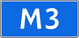
The Russian route M3 is a major trunk road that runs across a distance of about 490 kilometres from Moscow to Russia's border with Ukraine.

The European route E95 is an imagined route in Europe and a part of the United Nations International E-road network. Approximately 2,527 kilometres (1,570 mi) long, it connects Saint Petersburg with Merzifon in north central Turkey. Between its northern terminus in Russia and its southern end, it passes in addition through Belarus and Ukraine. Between the ports of Odesa / Chornomorsk on Ukraine's southern coast and ports of Turkey vehicles are required to cross the Black Sea by ferry over a distance of 731 kilometres (454 mi).
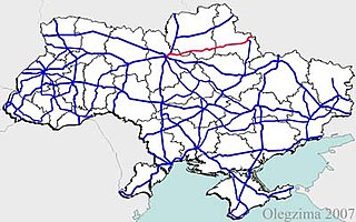
State highways in Ukraine are subdivided into four categories: international (M-network), national (H-network), regional (P-network), and territorial (Т-network). The letter's indexes are in Cyrillic, standing for their respective abbreviations in Ukrainian.

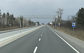
Highway M02 is a Ukraine international highway (M-highway) connecting the M01 near Kipti with Bachivsk on the border with Russia, where it continues as the M3 to Moscow. The entire route is part of European route E101 and the section from Hlukhiv to the Russian border is part of European route E391.

Highway M06 is a Ukrainian international highway (M-highway) connecting Kyiv to the Hungarian border near Chop, where it continues as Hungarian main road 4 to Záhony and Budapest.
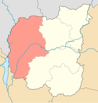
Chernihiv Raion is a raion (district) of Chernihiv Oblast, northern Ukraine. Its administrative centre is the city of Chernihiv. Population: 445,430.

Kozelets Raion was one of the 22 administrative raions of Chernihiv Oblast in northern Ukraine. Its administrative center was located at the urban-type settlement of Kozelets. Its population was 61,636 in the 2001 Ukrainian Census. The raion was abolished on 18 July 2020 as part of the administrative reform of Ukraine, which reduced the number of raions of Chernihiv Oblast to five. The area of Kozelets Raion was merged into Chernihiv Raion. The last estimate of the raion population was 42,282
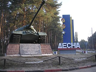
Desna is a rural settlement in Chernihiv Raion, Chernihiv Oblast, northern Ukraine. It hosts the administration of Desna settlement hromada, one of the hromadas of Ukraine. The settlement's population was 7,180 as of the 2001 Ukrainian census. Current population: 7,297. It is named after the Desna River which flows through the settlement.

The Belarusian-Ukrainian border is the state border between Belarus and Ukraine with a length of about 1,084 km (674 mi). It starts from the triple junction with Poland to the west and stretches to the triple junction with Russia to the east. The tripoint border at the triple border junction of Belarus, Russia and Ukraine is marked in the form of a monument, while at the other border junction there is a river, the Western Bug that coincides with the border of Poland.
Radul is a Rural settlement in Chernihiv Raion, Chernihiv Oblast, northern Ukraine. It is located on the left bank of the Dnieper, which here also makes the border between Ukraine and Belarus. It belongs to Ripky settlement hromada, one of the hromadas of Ukraine. Population: 444.
Zamhlai is a rural settlement in Chernihiv Raion, Chernihiv Oblast, northern Ukraine. It belongs to Ripky settlement hromada, one of the hromadas of Ukraine. Population: 1,723.
H07 is an important Ukraine national highway (H-highway) in Kyiv, Chernihiv, and Sumy Oblasts, Ukraine, running mainly west-east, and connecting Kyiv with Yunakivka in a more or less straight line. It begins in Brovary at Highway M01/Highway E95, and passes through Krasylivka, Hoholiv, Rusaniv, Peremoha, Nova Basan, Novyi Bykiv, Pohreby, Rudivka, Pryluky, Okhyrky, Sribne, Kharkove, Lavirkove, Romny, Korovyntsi, Nedryhailiv, Vylshana, Komyshanka, Shtepivka, Sula, Sad, Sumy, Stetskivka, Pysarivka, and Yunakivka, before ending at the Russian border. The road then continues as the R200 to Kursk.

The Kyiv Bridge or the Road bridge across the Desna is a currently destroyed brick-and-stone bridge over the Desna River in Chernihiv, Ukraine, located along Peace (Myru) Avenue.