
Coton is a small village and civil parish about three miles west of Cambridge in Cambridgeshire, England and about the same distance east of the Prime Meridian. It is in the district of South Cambridgeshire. The parish covers an area of 392 hectares. In the 2001 census it had a population of 773, with approximately 336 dwellings and 322 households. The population at the 2011 census was 910.

Boxgrove is a village, ecclesiastical parish and civil parish in the Chichester District of the English county of West Sussex, about 3.5 miles (5.6 km) north east of the city of Chichester. The village is just south of the A285 road which follows the line of the Roman road Stane Street.

Linton is a village and civil parish in Cambridgeshire, England, on the border with Essex. The village is approximately 8 miles (13 km) southeast from the city and county town of Cambridge. The A1307 passes through the village.

Hemingford Grey is a village and civil parish in Cambridgeshire, England. Hemingford Grey lies approximately 4 miles (6 km) east of Huntingdon. Hemingford Grey is situated within Huntingdonshire which is a non-metropolitan district of Cambridgeshire as well as being a historic county of England.

Whissonsett is a village and a civil parish in the English county of Norfolk. The village is 5.0 miles (8.0 km) south of Fakenham, 23 miles (37 km) west-north-west of Norwich and 112 miles (180 km) north-north-east of London. The nearest railway station is at King's Lynn for the Fen Line which runs between King's Lynn and Cambridge. The nearest airport is Norwich International Airport. The parish had in 2001 census, a population of 483 in 206 households, increasing to a population of 488 in 209 households at the 2011 Census. For the purposes of local government, the parish falls within the district of Breckland. The village lies close to the source of the River Wensum.

Acton Turville is a parish in the Cotswold Edge ward within South Gloucestershire, England. It lies 17 miles (27 km) east-northeast of Bristol. The M4 is south of the parish. Acton Turville consists of a cluster of households across 1,009 acres, with a total population of 370 people. Acton Turville is also listed as "Achetone" in the Domesday Book.

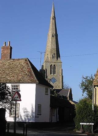
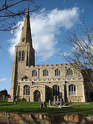
Buckden is a village and civil parish 3.7 miles (6.0 km) north of St Neots and 4 miles (6.4 km) south-west of Huntingdon, England. It includes the hamlets of Stirtloe and Hardwick. It lies in Huntingdonshire, a non-metropolitan district of Cambridgeshire and a historic county, close to three transport routes of past and present: the River Great Ouse, along its eastern boundary, the Great North Road that once crossed the village, but now bypasses it to the west, and the East Coast Mainline along the eastern side of the Great Ouse valley in the neighbouring parish of The Offords.

Diddington is a small village and civil parish in Cambridgeshire, England. Diddington lies approximately 5 miles (8 km) south-west of Huntingdon, near to Buckden. Diddington is situated within Huntingdonshire which is a non-metropolitan district of Cambridgeshire as well as being a historic county of England. Its population at the time of the 2011 census was 139.
Catworth is a village and civil parish in Cambridgeshire, England. Catworth lies approximately 9 miles (14 km) west of Huntingdon. The civil parish covers an area of 3,094 acres. Catworth village has two parts, Catworth, at the top of the hill, and Little Catworth, at the bottom. Catworth is situated within Huntingdonshire which is a non-metropolitan district of Cambridgeshire as well as being a historic county of England.

Covington is a village and civil parish in Cambridgeshire, England. Covington lies approximately 10 miles (16 km) west of Huntingdon near to Catworth and close to the county borders with both Bedfordshire and Northamptonshire. Covington is situated within Huntingdonshire which is a non-metropolitan district of Cambridgeshire as well as being a historic county of England. Covington. The civil parish covers an area of 1,294 acres. At the 2011 Census the population of the village was found to be less than 100 and was included in the civil parish of Tilbrook.

Hail Weston is a village and civil parish in Cambridgeshire, England. Hail Weston lies approximately 7 miles (11 km) south of Huntingdon. Hail Weston is situated within Huntingdonshire which is a non-metropolitan district of Cambridgeshire as well as being a historic county of England.
Ellington is a village and civil parish in Cambridgeshire, England, 4 miles (6 km) west of Huntingdon in Huntingdonshire, a non-metropolitan district of Cambridgeshire and historic county of England. The civil parish covers an area of 2,700 acres ; much of it is grassland with some small woods in the south of the parish.

Irby upon Humber or Irby-on-Humber is a small village and a civil parish in North East Lincolnshire, England. The village is situated on the A46 road, 1.5 miles (2.4 km) south-west of Laceby.

Topcliffe is a village and civil parish in North Yorkshire, England. The village is situated on the River Swale, on the A167 road and close to the A168. It is about 5 miles (8 km) south-west of Thirsk and 11 miles (18 km) south of the county town of Northallerton. It has a population of 1,489. An army barracks, with a Royal Air Force airfield enclosed within, is located to the north of the village.
Hinton Blewett is a village and civil parish in Somerset, England, 5 miles (8.0 km) north of Wells and 15 miles (24.1 km) south of Bristol on the northern slope of the Mendip Hills, within the designated Area of Outstanding Natural Beauty (AONB) and in the Chew Valley near the source of the River Chew. The parish has a population of 308.
East Witton is a village and civil parish in Wensleydale in North Yorkshire, England. It lies south of Leyburn, in the Richmondshire district. Richard Whiteley is buried there; he and his partner, Kathryn Apanowicz, lived in the village. In 2011 the parish had a population of 246.

Haslingfield (haiz-ling-field) is a village and civil parish in South Cambridgeshire, England. The village is about six miles south-west of Cambridge, between Harston, Barton and Barrington. The population in the 2001 census was 1,550 people living in 621 households, reducing at the 2011 Census to a population of 1,507 living in 626 households. The main streets in the village are called High Street and New Road which together form an approximate circle around the Manor House. The village contains Haslingfield Primary School and All Saints Church.

Willisham is a small village in the suburbs of the county town of Ipswich, Suffolk. The small parish village has been present since the 11th century and was included in the Domesday Book. During the 18th century the village was once home to wheat and barley farmers. During the 20th century the village has gained new homes with the local authority building at Fiske Pightle, and private dwellings in the cul-de-sac of North Acres being built in 1965/1966. In the year 2000 the village had 9 new houses built down Tye Lane. The village post office was renovated into a house 8 years ago. The 2011 census recorded a population of 362 people.
Croydon is a small village and civil parish in South Cambridgeshire, England. It is 10 miles (16 km) south-west of Cambridge and immediately west of the A1198 road. The population in 2001 was 221 people, increasing to 235 at the 2011 Census. The site of the deserted medieval village of Clopton is in Croydon parish, which was formerly known as Croydon-cum-Clopton.

Tadlow is a small village and civil parish in South Cambridgeshire, England on the River Cam. It is 20 kilometres (12 mi) south-west of Cambridge and 9 kilometres (6 mi) north-east of Biggleswade, Bedfordshire. In 2001 the population was 181 and the area of the village is 681 hectares.


