
U.S. Route 258 is a spur of US 58 in the U.S. states of North Carolina and Virginia. The U.S. Highway runs 220.15 miles (354.30 km) from US 17 Business and NC 24 Business in Jacksonville, North Carolina north to Virginia State Route 143 at Fort Monroe in Hampton, Virginia. In North Carolina, US 258 connects Jacksonville with the Inner Banks communities of Kinston, Snow Hill, Farmville, Tarboro, and Murfreesboro. The U.S. Highway continues through the Virginia city of Franklin, where the highway intersects US 58, and the town of Smithfield on its way to the Hampton Roads metropolitan area. US 258 crosses the James River on the James River Bridge and follows Mercury Boulevard through Newport News and Hampton.
The Valley campaigns of 1864 were American Civil War operations and battles that took place in the Shenandoah Valley of Virginia from May to October 1864. While some military historians divide this period into three separate campaigns, they interacted in several ways, so this article considers all three together.

Forks of Cacapon, formerly Forks of Capon, is an unincorporated community in Hampshire County in the U.S. state of West Virginia. The community is named for its location at the confluence of the North River and Cacapon River. Forks of Cacapon is also located at another fork: the crossroads of West Virginia Route 29, West Virginia Route 127, and Frank Haines Road.

The National Register of Historic Places in the United States is a register including buildings, sites, structures, districts, and objects. The Register automatically includes all National Historic Landmarks as well as all historic areas administered by the U.S. National Park Service. Since its introduction in 1966, more than 90,000 separate listings have been added to the register.
West Virginia Route 12 is a north–south route located in the southern portion of the U.S. state of West Virginia. The southern terminus of the route is at U.S. Route 219 in Peterstown, Monroe County, less than 300 yards (270 m) from the Virginia state line. It compromises a portion of the Farm Heritage Road byway between Peterstown and West Virginia Route 122. The northern terminus of the route is at U.S. Route 60 in Alta, Greenbrier County, near Interstate 64 exit 161.

Bunker Hill is an unincorporated community in Berkeley County, West Virginia, USA, located in the lower Shenandoah Valley on Winchester Pike at its junction with County Route 26 south of Martinsburg. It is the site of the confluence of Torytown Run and Mill Creek, a tributary of Opequon Creek which flows into Winchester, Virginia. According to the 2000 census, the Bunker Hill community has a population of 5,319.

U.S. Route 15 is a part of the U.S. Highway System that runs from Walterboro, South Carolina to Painted Post, New York. In Virginia, the U.S. Highway runs 230.37 miles (370.74 km) from the North Carolina state line near Clarksville north to the Maryland state line at the Potomac River near Lucketts. US 15 is a major north–south highway through the Piedmont of Virginia, connecting Clarksville and Farmville in Southside Virginia with Culpeper, Warrenton, and Leesburg in Northern Virginia.

State Route 16 is a primary state highway in the southwest part of the U.S. state of Virginia. It runs from the North Carolina border at North Carolina Highway 16 north to the West Virginia border at West Virginia Route 16, passing through the towns of Troutdale, Marion, and Tazewell. Highway 16 is part of a three-state route 16 that connects the Charlotte region with northwestern West Virginia.

State Route 42 is a primary state highway in the U.S. state of Virginia. Running parallel to and west of Interstate 81, SR 42 consists of three sections with gaps filled by secondary routes in between. Some of SR 42 lies along the old Fincastle Turnpike. Another major piece, from near Clifton Forge to Buffalo Gap, parallels the old Virginia Central Railroad.
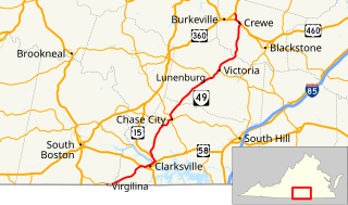
State Route 49 is a primary state highway in the U.S. state of Virginia. The state highway runs 69.01 miles (111.06 km) from the North Carolina state line in Virgilina, Virginia in Halifax County, where the highway continues south as North Carolina Highway 49, north to U.S. Route 360 near Burkeville in Nottoway County. SR 49 passes through Southside Virginia, connecting Virgilina and Burkeville with Clarksville and Chase City in Mecklenburg County, Victoria in Lunenburg County, and Crewe in Nottoway County. Via US 360, the state highway connects Richmond with the John H. Kerr Reservoir.
U.S. Route 60 (US 60) in the Commonwealth of Virginia runs 303 miles (488 km) west to east through the central part of the state, generally close to and paralleling the Interstate 64 corridor, except for the crossing of the Blue Ridge Mountains, and in the South Hampton Roads area.
In the U.S. state of West Virginia, U.S. Route 40 (US 40) runs for 16 miles (26 km) through the Northern Panhandle region. The highway enters the state on the Military Order of the Purple Heart bridge concurrent with US 250, crossing Wheeling Island, before joining Interstate 70 (I-70) over the Fort Henry Bridge before leaving the interstate. The highway travels north around Wheeling Hill, before traveling through the northeastern suburbs of Wheeling, Triadelphia and Valley Grove before entering Pennsylvania. A majority of the route still follows the old National Road which predates the U.S. Highway System.
The roads of Charleston, West Virginia, include three major interstate highways, several U.S. highways and state routes, and numerous major thoroughfares.

The Great Indian Warpath (GIW)—also known as the Great Indian War and Trading Path, or the Seneca Trail—was that part of the network of trails in eastern North America developed and used by Native Americans which ran through the Great Appalachian Valley. The system of footpaths extended from what is now upper New York to deep within Alabama. Various Indians traded and made war along the trails, including the Catawba, numerous Algonquian tribes, the Cherokee, and the Iroquois Confederacy. The British traders' name for the route was derived from combining its name among the northeastern Algonquian tribes, Mishimayagat or "Great Trail", with that of the Shawnee and Delaware, Athawominee or "Path where they go armed".
Interstate 70 (I-70) is a portion of the Interstate Highway System that runs from near Cove Fort, Utah, at a junction with Interstate 15 to Baltimore, Maryland. It crosses the Northern Panhandle of West Virginia through Ohio County and the city of Wheeling. This segment is the shortest of all states' through which I-70 passes, crossing West Virginia in only 14.45 miles (23.26 km). The longest segment is Colorado's, which measures 451.04 miles (725.88 km). The Fort Henry Bridge carries I-70 from Wheeling Island across the Ohio River and into downtown Wheeling before the freeway enters the Wheeling Tunnel. I-470, a southerly bypass of Wheeling and the lone auxiliary Interstate Highway in West Virginia, is intersected near Elm Grove. Before crossing into Pennsylvania, I-70 passes The Highlands, a major shopping center in the panhandle, and the Bear Rock Lakes Wildlife Management Area. On average, between 27,000 and 53,000 vehicles use the freeway every day.
Sharon is an unincorporated community and coal town in southeastern Kanawha County, West Virginia, United States, located along the West Virginia Turnpike.
U.S. Route 11 (US 11) in the U.S. state of West Virginia spans 26.2 miles (42.2 km) across the Eastern Panhandle region. US 11 enters the state near Ridgeway, and crosses into Maryland just south of Williamsport. The highway closely parallels Interstate 81 (I-81) for its entire length.

Arbuckle Magisterial District is one of ten magisterial districts in Mason County, West Virginia. The district was originally established as a civil township in 1863, and converted into a magisterial district in 1872. In 2010, Arbuckle District was home to 1,121 people.

Ravenswood District, formerly Ravenswood Magisterial District, is one of five historic magisterial districts in Jackson County, West Virginia. The district was originally known as Gilmore Township, one of five civil townships established in 1863; the name officially became "Ravenswood" in 1871, and Jackson County's townships were converted into magisterial districts in 1872. When Jackson County was redistricted in the 1990s, the area of Ravenswood District was divided between the new Northern and Western Magisterial Districts. However, the county's historic magisterial districts continue to exist in the form of tax districts, serving all of their former administrative functions except for the election of county officials.


