West Virginia is a state in the Appalachian, Mid-Atlantic and Southeastern regions of the United States. It is bordered by Pennsylvania to the northeast, Maryland to the east and northeast, Virginia to the southeast, Kentucky to the southwest, and Ohio to the northwest. West Virginia is the 41st-largest state by area and ranks 38th in population, with a population of 1,795,045 residents. The capital and largest city is Charleston.

Charleston is the capital and most populous city of the U.S. state of West Virginia. Located at the confluence of the Elk and Kanawha rivers, the city had a population of 51,400 at the 2010 census and an estimated population of 46,536 in 2019. The Charleston metropolitan area as a whole had an estimated 208,089 residents in 2019. Charleston is the center of government, commerce, and industry for Kanawha County, of which it is the county seat.

Logan is a city in Logan County, West Virginia, United States, along the Guyandotte River. The population was 1,779 at the 2010 census. It is the county seat of Logan County.

West Virginia University (WVU) is a public, land-grant, research university with its main campus in Morgantown, West Virginia. Its other campuses are those of the West Virginia University Institute of Technology in Beckley, Potomac State College of West Virginia University in Keyser, and a second clinical campus for the university's medical and dental schools at Charleston Area Medical Center in Charleston. WVU Extension Service provides outreach with offices in all of West Virginia's 55 counties.

The Norfolk and Western Railway was a US class I railroad, formed by more than 200 railroad mergers between 1838 and 1982. It was headquartered in Roanoke, Virginia, for most of its existence. Its motto was "Precision Transportation"; it had a variety of nicknames, including "King Coal" and "British Railway of America".

The Super Y League is a youth soccer league with teams from the United States and Canada. Founded in 1999, the Super Y League is dedicated to the progression of future professional players and has steered the course for development of elite clubs, players and coaches. Affiliated with U.S. Soccer, the Super Y League has opened countless doors for players to be identified for U.S. National Team programs. The Super Y League contains the youth academies of Major League Soccer, United Soccer League and Premier Development League clubs. The league also serves clubs looking to develop the game from the ground up.
The following is a set–index article, providing a list of lists, for the cities, towns and villages within the jurisdictional United States. It is divided, alphabetically, according to the state, territory, or district name in which they are located.

State Route 175 (SR 175) is a primary state highway in the U.S. state of Virginia. Known as Chincoteague Road, the state highway runs 10.49 miles (16.88 km) from U.S. Route 13 (US 13) at Nash Corner east to Main Street in Chincoteague. SR 175 passes through the northeastern corner of Accomack County, providing the primary access to NASA's Wallops Flight Facility and both Chincoteague Island and the Virginia portion of Assateague Island. The route travels between the mainland and Chincoteague Island along the John B. Whealton Memorial Causeway.
The Huntington–Ashland metropolitan area is a metropolitan area in the Appalachian Plateau region of the United States. Referred to locally as the “Tri-State area”, the region spans seven counties in the three states of West Virginia, Kentucky, and Ohio. With a population of 361,580, the Tri-State area is nestled along the banks of the Ohio River. The region offers a diverse range of outdoor activities.
The Great Eastern Trail is a north-south hiking route that runs roughly 1,600 miles (2,600 km) through the Appalachian Mountains west of the Appalachian Trail in the eastern United States. As of 2019, it is still under development. From south to north, it runs from Flagg Mountain in Alabama through Georgia, Tennessee, Kentucky, West Virginia, Virginia, Maryland, and Pennsylvania, ending in western New York state. A connection from Flagg Mountain south to the Florida-Georgia border is considered "Phase II Development".
Stereotypes of white people in the United States are generalizations about the character, behavior, or appearance of white Americans.

Barrio Chino is a neighborhood located in the downtown area of Mexico City, near the Palacio de Bellas Artes. The neighborhood is located on two blocks of Dolores Street and consists of a number of restaurants and businesses that import goods. The neighborhood consists of approximately 3,000 families with Chinese heritage in Mexico City.

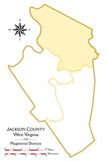
The Northern Magisterial District is one of three magisterial districts in Jackson County, West Virginia. It was established during a process of redistricting undertaken in the 1990s. In 2010, 8,753 people lived in the district.

The Western Magisterial District is one of three magisterial districts in Jackson County, West Virginia. It was established during a process of redistricting undertaken in the 1990s. In 2010, 10,576 people lived in the district.


