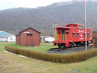
Rowlesburg is a town in southern Preston County, West Virginia, United States, along the Cheat River. The population was 438 at the 2020 census. It is part of the Morgantown metropolitan area. A former railroad town, it is home to the Downtown Rowlesburg Historic District, and was the site of action during the American Civil War.
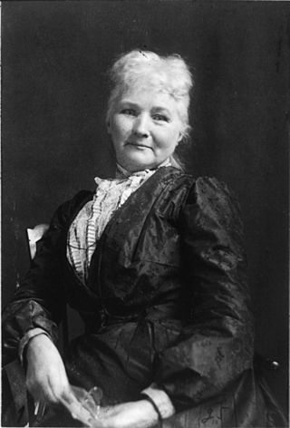
Mary G. Harris Jones, known as Mother Jones from 1897 onwards, was an Irish-born American labor organizer, former schoolteacher, and dressmaker who became a prominent union organizer, community organizer, and activist. She helped coordinate major strikes, secure bans on child labor, and co-founded the socialist trade union, the Industrial Workers of the World (IWW).
The Virginian Railway was a Class I railroad located in Virginia and West Virginia in the United States. The VGN was created to transport high quality "smokeless" bituminous coal from southern West Virginia to port at Hampton Roads.

U.S. Route 258 is a spur of US 58 in the U.S. states of North Carolina and Virginia. The U.S. Highway runs 220.15 miles (354.30 km) from US 17 Business and NC 24 Business in Jacksonville, North Carolina north to Virginia State Route 143 at Fort Monroe in Hampton, Virginia. In North Carolina, US 258 connects Jacksonville with the Inner Banks communities of Kinston, Snow Hill, Farmville, Tarboro, and Murfreesboro. The U.S. Highway continues through the Virginia city of Franklin, where the highway intersects US 58, and the town of Smithfield on its way to the Hampton Roads metropolitan area. US 258 crosses the James River on the James River Bridge and follows Mercury Boulevard through Newport News and Hampton.

Virginia Mayo was an American actress and dancer. She was in a series of comedy films with Danny Kaye and was Warner Brothers' biggest box-office money-maker in the late 1940s. She also co-starred in the 1946 Oscar-winning movie The Best Years of Our Lives and White Heat (1949).

A toll tunnel is a road tunnel where a monetary charge is required to pass through.

The Valley campaigns of 1864 began as operations initiated by Union Lieutenant General Ulysses S. Grant and resulting battles that took place in the Shenandoah Valley of Virginia during the American Civil War from May to October 1864. Some military historians divide this period into three separate campaigns. This article considers them together, as the campaigns interacted and built upon one another.
The Northwestern Turnpike is a historic road in West Virginia, important for being historically one of the major roads crossing the Appalachians, financed by the Virginia Board of Public Works in the 1830s. In modern times, west of Winchester, Virginia, U.S. Route 50 follows the path of the Northwestern Turnpike into West Virginia, whose major Corridor D project follows the western section of the original Northwestern Turnpike.

The National Register of Historic Places in the United States is a register including buildings, sites, structures, districts, and objects. The Register automatically includes all National Historic Landmarks as well as all historic areas administered by the U.S. National Park Service. Since its introduction in 1966, more than 90,000 separate listings have been added to the register.

West Virginia Route 28 is a north–south route through the Potomac Highlands of the U.S. state of West Virginia. The southern terminus of the route is at West Virginia Route 39 in Huntersville. The northern terminus is at the Maryland state line in Wiley Ford, where the route continues into Cumberland as Canal Parkway upon crossing the North Branch Potomac River.
The Battle of Fairfield was a cavalry engagement during the Gettysburg Campaign of the American Civil War. It was fought July 3, 1863, near Fairfield, Pennsylvania, concurrently with the Battle of Gettysburg, although it was not a formal part of that battle. While a minor fight by the small number of troops deployed, strategically, the Confederate victory secured the important Hagerstown Road, which Robert E. Lee's Army of Northern Virginia would use on July 5 to return to Maryland and then on to safety in Virginia.
State Route 49 is a primary state highway in the U.S. state of Virginia. The state highway runs 69.01 miles (111.06 km) from the North Carolina state line in Virgilina, Virginia in Halifax County, where the highway continues south as North Carolina Highway 49, north to U.S. Route 360 near Burkeville in Nottoway County. SR 49 passes through Southside Virginia, connecting Virgilina and Burkeville with Clarksville and Chase City in Mecklenburg County, Victoria in Lunenburg County, and Crewe in Nottoway County. Via US 360, the state highway connects Richmond with the John H. Kerr Reservoir.

U.S. Route 60 (US 60) in the Commonwealth of Virginia runs 303 miles (488 km) west to east through the central part of the state, generally close to and paralleling the Interstate 64 corridor, except for the crossing of the Blue Ridge Mountains, and in the South Hampton Roads area.

The Great Indian Warpath (GIW)—also known as the Great Indian War and Trading Path, or the Seneca Trail—was that part of the network of trails in eastern North America developed and used by Native Americans which ran through the Great Appalachian Valley. The system of footpaths extended from what is now upper New York to deep within Alabama. Various Native peoples traded and made war along the trails, including the Catawba, numerous Algonquian tribes, the Cherokee, and the Iroquois Confederacy. The British traders' name for the route was derived from combining its name among the northeastern Algonquian tribes, Mishimayagat or "Great Trail", with that of the Shawnee and Delaware, Athawominee or "Path where they go armed".
U.S. Route 250 is a part of the U.S. Highway System that runs from Sandusky, Ohio to Richmond, Virginia. In Virginia, the highway runs 166.74 miles (268.34 km) from the West Virginia state line near Hightown east to its eastern terminus at US 360 in Richmond. US 250 is the main east–west highway of Highland County, which is known as Virginia's Little Switzerland; the highway follows the path of the 19th century Staunton and Parkersburg Turnpike. From Staunton east to Richmond, the highway serves as the local complement to Interstate 64 (I-64), roughly following the 18th century Three Notch'd Road through Waynesboro and Charlottesville on its way through the Shenandoah Valley, its crossing of the Blue Ridge Mountains at Rockfish Gap, and the Piedmont. In the Richmond metropolitan area, US 250 is known as Broad Street, a major thoroughfare through the city's West End and downtown areas.

Pennsylvania Route 381 is a 49.3-mile-long (79.3 km) state highway located in Fayette, and Westmoreland counties in Pennsylvania. The southern terminus is the West Virginia state line near Elliottsville, Pennsylvania, where it continues as Preston County Route 8 to its southern terminus at WV 26 in Brandonville, West Virginia. The northern terminus is at U.S. Route 30 (US 30) near Ligonier.

The B & O Railroad Potomac River Crossing is a 15-acre (6.1 ha) historic site where a set of railroad bridges, originally built by the Baltimore and Ohio Railroad, span the Potomac River between Sandy Hook, Maryland and Harpers Ferry, West Virginia. The site was added to the National Register of Historic Places on February 14, 1978, for its significance in commerce, engineering, industry, invention, and transportation.
The Jones–Imboden Raid was a Confederate military action conducted in western Virginia in April and May 1863 during the American Civil War. The raid, led by Brig. Gens. William E. Jones and John D. Imboden, was aimed at disrupting traffic on the vital Baltimore and Ohio Railroad and reasserting Confederate authority in transmountain Virginia in an effort to derail the growing statehood movement in the region, since voters had in March approved a new Constitution and statehood only awaited Congressional and Presidential approval.

A ford is a shallow place with good footing where a river or stream may be crossed by wading, or inside a vehicle getting its wheels wet. A ford may occur naturally or be constructed. Fords may be impassable during high water. A low-water crossing is a low bridge that allows crossing over a river or stream when water is low but may be treated as a ford when the river is high and water covers the crossing.


