
George Washington was an American military officer, statesman, and Founding Father who served as the first president of the United States from 1789 to 1797. Appointed by the Second Continental Congress as commander of the Continental Army in June 1775, Washington led Patriot forces to victory in the American Revolutionary War and then served as president of the Constitutional Convention of 1787, which created and ratified the Constitution of the United States and the American federal government. Washington has been called the "Father of his Country" for his manifold leadership in the nation's founding.

The Appalachian Mountains, often called the Appalachians, are a system of mountains in eastern to northeastern North America. The Appalachians first formed roughly 480 million years ago during the Ordovician Period. They once reached elevations similar to those of the Alps and the Rocky Mountains before experiencing natural erosion. The Appalachian chain is a barrier to east–west travel, as it forms a series of alternating ridgelines and valleys oriented in opposition to most highways and railroads running east–west.

Interstate 64 (I-64) is an east–west Interstate Highway in the Eastern United States. Its western terminus is at I-70, U.S. Route 40 (US 40), and US 61 in Wentzville, Missouri. Its eastern terminus is at an interchange with I-264 and I-664 at Bower's Hill in Chesapeake, Virginia. I-64 connects the major metropolitan areas of St. Louis, Missouri; Louisville and Lexington in Kentucky; Charleston, West Virginia; and Richmond and Hampton Roads in Virginia.

Mount Vernon is a census-designated place (CDP) and unincorporated community in Fairfax County, Virginia, United States. The population was 12,416 at the 2010 census. Primarily due to its historical significance and natural recreation and beauty, the Mount Vernon area receives over one million tourists each year.

Mount Gay-Shamrock is a census-designated place (CDP) in Logan County, West Virginia, United States.

The Blue Ridge Mountains are a physiographic province of the larger Appalachian Mountains range. The mountain range is located in the Eastern United States, and extends 550 miles southwest from southern Pennsylvania through Maryland, West Virginia, Virginia, North Carolina, South Carolina, Tennessee, and Georgia. This province consists of northern and southern physiographic regions, which divide near the Roanoke River gap. To the west of the Blue Ridge, between it and the bulk of the Appalachians, lies the Great Appalachian Valley, bordered on the west by the Ridge and Valley province of the Appalachian range.

The Allegheny Front is the major southeast- or east-facing escarpment in the Allegheny Mountains in southern Pennsylvania, western Maryland, eastern West Virginia, and western Virginia, USA. The Allegheny Front forms the boundary between the Ridge-and-Valley Appalachians to its east and the Appalachian Plateau to its west. The Front is closely associated with the Appalachian Mountains' Eastern Continental Divide, which in this area divides the waters of the Ohio/Mississippi river system, flowing to the Gulf of Mexico, from rivers flowing into Chesapeake Bay and from there into the Atlantic Ocean.
The Potomac Heritage Trail, also known as the Potomac Heritage National Scenic Trail or the PHT, is a designated National Scenic Trail corridor spanning parts of the mid-Atlantic region of the United States that will connect various trails and historic sites in Virginia, Maryland, Pennsylvania, and the District of Columbia. The trail network includes 710 miles (1,140 km) of existing and planned sections, tracing the natural, historical, and cultural features of the Potomac River corridor, the upper Ohio River watershed in Pennsylvania and western Maryland, and a portion of the Rappahannock River watershed in Virginia. The trail is managed by the National Park Service and is one of three National Trails that are official NPS units.

The George Washington and Jefferson National Forests is an administrative entity combining two U.S. National Forests into one of the largest areas of public land in the Eastern United States. The forests cover 1.8 million acres (2,800 sq mi) of land in the Appalachian Mountains of Virginia, West Virginia, and Kentucky. Approximately 1 million acres (1,600 sq mi) of the forest are remote and undeveloped and 139,461 acres (218 sq mi) have been designated as wilderness areas, which prohibits future development.

Three Churches is an unincorporated community in Hampshire County in the U.S. state of West Virginia. The town is located north of Romney along Jersey Mountain Road at a crossroads with Three Churches Hollow Road. Originally known as Jersey Mountain, Three Churches was renamed for the three historic white wooden churches located there: Mount Bethel Church, Mount Bethel Primitive Baptist Church, and Branch Mountain United Methodist Church. The Three Churches Post Office is no longer in service.

Mount Storm Lake – also known as New Stony River Reservoir – is a 1,200 acres (4.9 km2) reservoir created in 1965 on the Stony River in Grant County, West Virginia. It serves as a cooling pond for the Dominion 1.6 gigawatt Mount Storm Power Station, which provides electricity to more than two million customers in Northern Virginia. The reservoir stands at an altitude of 3,244 feet (989 m).
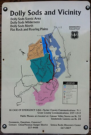
Mount Porte Crayon is a mountain in the Roaring Plains Wilderness of the Monongahela National Forest in the northeastern corner of Randolph County, West Virginia, USA. It rises to an elevation of 4,770 feet (1,450 m), the elevational climax of the Allegheny Front. The mountain is named for 19th century writer and illustrator David Hunter Strother (1816–88), known as "Porte Crayon", who produced a wide array of early West Virginia landscapes in his work.

Southern West Virginia is a culturally and geographically distinct region in the U.S. state of West Virginia. Southern West Virginia is known for its coal mining heritage and Southern affinity. The region is also closely identified with Southwestern Virginia and Southeastern Kentucky, with close proximity to Western North Carolina and East Tennessee. Today, Southern West Virginia continues to grapple with poverty and declining population. The region is located in West Virginia's 1st congressional district, which is represented by Carol Miller.
Waldo Porter Johnson was an American politician who served as a Confederate States Senator from Missouri from 1863 to 1865.

The Weirton–Steubenville, WV–OH Metropolitan Statistical Area, also known as the Upper Ohio Valley, is a metropolitan statistical area consisting of two counties in the Northern Panhandle of West Virginia and one in Ohio, anchored by the cities of Weirton and Steubenville. As of the 2020 census, the MSA had a population of 116,903. This puts it at 334th largest in the United States. It is also included in the larger Pittsburgh–New Castle–Weirton, PA–OH–WV Combined Statistical Area.

Mount Carbon is a census-designated place (CDP) in Fayette County, West Virginia, United States. Mount Carbon is located along West Virginia Route 61, 3 miles (4.8 km) southeast of Montgomery, on the south bank of the Kanawha River at the mouth of Armstrong Creek. Mount Carbon has a post office with ZIP code 25139. As of the 2010 census, its population was 428.
Mount Olive is an unincorporated community in Fayette County, West Virginia, United States. Mount Olive is 5.5 miles (8.9 km) north-northwest of Gauley Bridge. The town itself has no ZIP code; however, Mount Olive Correctional Complex, West Virginia's maximum-security state prison, is located near the town and has a post office with ZIP code 25185.
Sarah Johnson was an African American woman who was born into slavery at Mount Vernon, George Washington's estate in Fairfax, Virginia. She worked as a domestic, cleaning and caring for the residence. During the process, she became an informal historian of all of the mansion's furnishings. After the end of the Civil War, she was hired by the Mount Vernon Ladies' Association, ultimately becoming a council member of the organization. She bought four acres of Mount Vernon land to establish a small farm. The book Sarah Johnson's Mount Vernon (2008) tells the story of her life within the complex community of people who inhabited Mount Vernon.
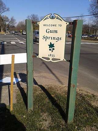
Gum Springs is a community in Fairfax County in Hybla Valley along Route 1. The African American community, the oldest in the county, was established in 1833 by West Ford, a freedman who had been manumitted by Hannah Bushrod Washington, in 1805. A historical marker was erected by the Virginia Department of Historic Resources in 1991.


