U.S. Route 550 (US 550) is a spur of U.S. Highway 50 that runs from Bernalillo, New Mexico to Montrose, Colorado in the western United States. The section from Silverton to Ouray is frequently called the Million Dollar Highway.

Oregon Route 213 is an Oregon state highway that serves the eastern Willamette Valley between Portland and Salem. It is a north–south route. The route is known as the Cascade Highway, though specific segments are generally better known by more localized names.

Springfield is a census-designated place (CDP) in northwestern Hampshire County in the U.S. state of West Virginia. As of the 2010 census, Springfield had a population of 477. Springfield is located north of Romney along West Virginia Route 28 at its junction with Green Spring Road and Springfield Pike. It is currently considering incorporation.

Kirby is an unincorporated community in Hampshire County in the U.S. state of West Virginia situated along Grassy Lick Run, a tributary of North River. Kirby is located south of Romney at the crossroads of Grassy Lick Road and Rock Oak Road.

Pleasant Dale is an unincorporated community in Hampshire County in the U.S. state of West Virginia. Pleasant Dale is located between Capon Bridge and Augusta on the Northwestern Turnpike. Tearcoat Creek flows through Pleasant Dale and offers whitewater rafting in the Spring from the U.S. Route 50 bridge to its confluence with the North River.
Purgitsville is an unincorporated community in Hampshire County in the U.S. state of West Virginia. According to the 2000 census, the ZCTA for Purgitsville had a population of 813. Purgitsville is located on U.S. Highway 220/West Virginia Route 28 at its intersection with Huffman Road south of Junction. An elementary school, Mill Creek Elementary, was open here until 1993 when it was consolidated with Romney Elementary.
Loom is an unincorporated community in Hampshire County, West Virginia, United States. Loom is located between Capon Bridge and Hanging Rock along the Northwestern Turnpike on the western flanks of Cooper Mountain. Timber Mountain Road and Beck's Gap Road converge at Loom on U.S. Route 50.
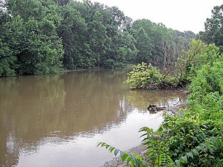
Rada is an unincorporated community in Hampshire County in the U.S. state of West Virginia. Rada is located on U.S. Highway 220/West Virginia Route 28 between Junction and Purgitsville in southwest Hampshire County along Mill Creek. It lies at an intersection of US 220/WV 28 with Rada Road.
In the U.S. state of West Virginia, Interstate 77 (I-77) is a major north–south Interstate highway. It extends for 187.21 miles (301 km) between Bluefield at the Virginia state line to Williamstown at the Ohio state line.
Sandy Creek is a tributary of the Ohio River in western West Virginia in the United States. Via the Ohio River, it is part of the watershed of the Mississippi River, draining an area of 124 square miles (320 km2) on the unglaciated portion of the Allegheny Plateau. The creek is 22 miles (35 km) long, or 38.3 miles (61.6 km) including its Left Fork.

The Huntington–Ashland metropolitan area is the largest metropolitan statistical area in West Virginia and includes seven counties across three states: West Virginia, Kentucky, and Ohio. New definitions from February 28, 2013 placed the population at 361,580. The MSA is nestled along the banks of the Ohio River within the Appalachian Plateau region. The area is referred to locally as the "Tri-State area". In addition, the three largest cities are referred to as the River Cities.

Big Chimney is a census-designated place (CDP) located on U.S. Route 119 in Kanawha County, West Virginia, United States. As of the 2010 census, its population was 627. It is accessible by West Virginia Route 114 or exit 5 from I-79. The center of town includes a Hardee's, a drug store, hardware store and grocery store, along with a few smaller businesses. The town is named after the tall chimney of the local salt works, which was a prominent landmark.
Bream is an unincorporated community along Indian Creek Rd in Kanawha County, West Virginia. It is the first community after State Route 114 turns across the Elk River to Big Chimney. Bream is located between Milliken and Pinch, and is usually omitted from the map, because of its size.
Hico is a census-designated place (CDP) in Fayette County, West Virginia, United States. Hico is located at the junction of U.S. Route 19 and U.S. Route 60 7 miles (11 km) northeast of Fayetteville. Hico has a post office with ZIP code 25854. As of the 2010 census, its population was 272.
Linwood is an unincorporated community in Pocahontas County, West Virginia, United States. Linwood is located at the junction of U.S. Route 219, West Virginia Route 55, and West Virginia Route 66 14 miles (23 km) north-northeast of Marlinton.
Mace is an unincorporated community in Pocahontas County, West Virginia, United States. Mace is located on U.S. Route 219 and West Virginia Route 55 16.5 miles (26.6 km) north-northeast of Marlinton.
Fellowsville is an unincorporated community in Preston County, West Virginia, United States. Fellowsville is located at the junction of U.S. Route 50 and West Virginia Route 26 4.5 miles (7.2 km) south-southeast of Newburg.
Valley Bend is a census-designated place (CDP) in Randolph County, West Virginia, United States. Valley Bend is located on U.S. Route 219, U.S. Route 250, West Virginia Route 55, and West Virginia Route 92 3.5 miles (5.6 km) northwest of Mill Creek. Valley Bend has a post office with ZIP code 26293. As of the 2010 census, its population was 485.
Deerwalk is an unincorporated community in Wood County, West Virginia, United States. Deerwalk is located on West Virginia Route 31 north of its junction with U.S. Route 50, 12.5 miles (20.1 km) east of Parkersburg.
Silverton is an historic town in Douglas County, Missouri. The GNIS classifies it as a populated place. It was located along County Road 317 on Spring Creek 1.7 miles (2.7 km) NNE of Wasola and 1.9 miles (3.1 km) west of the Hilo Cemetery along Route N on Hilo Ridge. Although Hilo is listed as a variant name, the two were not at the same location.


