
Burlington is a census-designated place (CDP) in Lawrence County, Ohio, United States. The population was 2,794 at the 2000 census. Burlington is a part of the Huntington-Ashland, WV-KY-OH, Metropolitan Statistical Area (MSA). As of the 2000 census, the MSA had a population of 288,649. The community is situated between the villages of South Point and Chesapeake. Its other neighbor is Huntington, West Virginia, which lies across the Ohio River; it is connected via the West Huntington Bridge. Burlington was once the leading community of Lawrence County, being the first county seat and the location of the county's first post office.

The Little Kanawha River is a tributary of the Ohio River, 169 mi (269 km) long, in western West Virginia in the United States. Via the Ohio, it is part of the watershed of the Mississippi River, draining an area of 2,320 mi² (6,009 km²) on the unglaciated portion of the Allegheny Plateau. It served as an important commercial water route in the early history of West Virginia, particularly in the logging and petroleum industries.

The Williams River is a tributary of the Gauley River, 33 miles (53 km) long, in east-central West Virginia, USA. Via the Gauley, Kanawha and Ohio Rivers, it is part of the watershed of the Mississippi River, draining an area of 132 square miles (342 km²) in a sparsely populated region of the southern Allegheny Mountains and the unglaciated portion of the Allegheny Plateau.

Glady Fork is a 31.9-mile-long (51.3 km) river in the Allegheny Mountains of eastern West Virginia, USA. It is considered one of the five principal headwaters tributaries of the Cheat River — known as the Forks of Cheat.

Roundhead is an unincorporated community in southeastern Roundhead Township, Hardin County, Ohio, United States. Although it is unincorporated, it has a post office, with the ZIP code of 43346. Located at an altitude of 1,004 feet (306 m), it sits at the intersection of State Routes 117, 235, and 385, 2¾ mile north of the northeast corner of Indian Lake and 13 miles (24 km) southwest of the city of Kenton, the county seat of Hardin County. Despite Roundhead's proximity to Indian Lake and the Great Miami River, which flows out of it to the Ohio River at Cincinnati, the community is drained by the headwaters of the Scioto River, which meets the Ohio River at Portsmouth.

Wheeling Creek is a tributary of the Ohio River, 25 miles (40 km) long, in the Northern Panhandle of West Virginia in the United States, with a watershed extending into southwestern Pennsylvania. Via the Ohio River, it is part of the watershed of the Mississippi River, draining an area of approximately 300 square miles (780 km2) on the unglaciated portion of the Allegheny Plateau. It flows into the Ohio River in downtown Wheeling, just downstream of Ohio's Wheeling Creek on the opposite bank. A variant name is Big Wheeling Creek.
Sandy Creek is a tributary of the Ohio River in western West Virginia in the United States. Via the Ohio River, it is part of the watershed of the Mississippi River, draining an area of 124 square miles (320 km2) on the unglaciated portion of the Allegheny Plateau. The creek is 22 miles (35 km) long, or 38.3 miles (61.6 km) including its Left Fork.

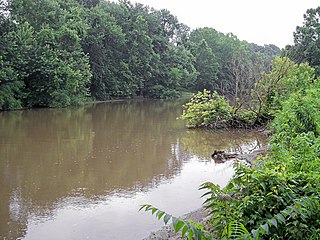
Orma is an unincorporated community in Calhoun County, West Virginia, United States. It lies along West Virginia Route 16 and the West Fork Little Kanawha River, to the south of the town of Grantsville, the county seat of Calhoun County. Its elevation is 738 feet. Although it is unincorporated, it has a post office, with the ZIP code of 25268.
Arnoldsburg is an unincorporated community in Calhoun County, West Virginia, United States. It lies along U.S. Route 33 at the point where West Virginia Route 16 heads southward; it is several miles south of the county seat of Grantsville. Its elevation is 738 feet. The West Fork Little Kanawha River flows through the community. Although it is unincorporated, it has a post office, with the ZIP code of 25234.
Proctor is an unincorporated community in northwestern Wetzel County, West Virginia, United States. It lies on West Virginia Route 2 along the Ohio River, north of the city of New Martinsville, the county seat of Wetzel County. Its elevation is 630 feet (192 m). Because the community has borne multiple names, the Board on Geographic Names officially designated it "Proctor" in 1980. Although it is unincorporated, it has a post office, with the ZIP code of 26055.
Rock Castle is an unincorporated community in southwestern Jackson County, West Virginia, United States. It lies along Rock Castle Road south of the city of Ripley, the county seat of Jackson County. Its elevation is 705 feet (215 m).
Murraysville is an unincorporated community in northern Jackson County, West Virginia, United States, along the Ohio River across from Long Bottom, Ohio. It lies along Murraysville Road north of the city of Ripley, the county seat of Jackson County. Its elevation is 591 feet (180 m).
Millwood is an unincorporated community in northwestern Jackson County, West Virginia, United States, along the Ohio River at the mouth of Mill Creek. It lies along West Virginia Routes 2 and 62 northwest of the city of Ripley, the county seat of Jackson County. Its elevation is 577 feet (176 m). Although Millwood is unincorporated, it has a post office, with the ZIP code of 25262.
Kentuck is an unincorporated community in southeastern Jackson County, West Virginia, United States. It lies along Kentuck Road southeast of the city of Ripley, the county seat of Jackson County. Its elevation is 922 feet (281 m).
Kenna is an unincorporated community in southern Jackson County, West Virginia, USA. It lies along West Virginia Route 34 just west of its interchange with Interstate 77, south of the city of Ripley, the county seat of Jackson County. Its elevation is 787 feet (240 m). Although Kenna is unincorporated, it has a post office, with the ZIP code of 25248.
Advent is an unincorporated community in southeastern Jackson County, West Virginia, United States. It lies along Advent Road southeast of the city of Ripley, the county seat of Jackson County, and near Jackson County's borders with Kanawha and Roane counties. Its elevation is 791 feet (241 m). Advent had a post office, which closed on December 25, 2010.

Left Hand is an unincorporated community in southeastern Roane County, West Virginia, United States. It lies along West Virginia Route 36 southeast of the city of Spencer, the county seat of Roane County. Its post office is still active.
Neola is an unincorporated community in northeastern Greenbrier County, West Virginia, United States. It lies along West Virginia Route 92 north of the city of White Sulphur Springs. Its elevation is 2,037 feet (621 m).
Pond Creek is an unincorporated community located in Wood County, West Virginia, along the Ohio River at the mouth of Pond Creek.

Loop Creek, also known by the spelling Loup Creek, is a tributary of the Kanawha River, 20 miles (32 km) long, in southern West Virginia in the United States. Via the Kanawha and Ohio rivers, it is part of the watershed of the Mississippi River, draining an area of 49.6 square miles (128 km2) in a coal mining region on the unglaciated portion of the Allegheny Plateau.


