Hirshabelle

Last updated

Hirshabelle State of Somalia
  • Maamul-Goboleedka Hirshabeele ee Soomaaliya (Somali)
  • ولاية هيرشابيل الصومال  (Arabic)
  • Wilāyat hirshabeele aṣ-Ṣūmāl
Flag of Hirshabelle.svg
Flag
Hirshabelle coat of arms high quality.png
Coat of arms
Anthem: Qolobaa Calankeed
Location Hirshabelle.png
Capital
and largest city
Jowhar
04°44′09″N045°12′13″E / 4.73583°N 45.20361°E / 4.73583; 45.20361
Official languages Somali
Ethnic groups
Somali
Religion
Islam
Demonym(s) Somali
Government Federated state under a presidential democracy
  Governor
Ali Abdullahi Hussein
Yusuf Ahmed Hagar Dabageed
Autonomy Federal Member State  
within Somalia
Population
 2019 estimate
1,964,100 (estimate) [1]
HDI 0.3
low
Currency Somali shilling (SOS)
Time zone UTC+3 (EAT)
 Summer (DST)
UTC+3 (not observed)
Calling code +252 (Somalia)
ISO 3166 code SO
Internet TLD .so

Hirshabelle, officially Hirshabelle State of Somalia (Somali: Maamul-Goboleedka Hirshabelle ee Soomaaliya ), is a Federal Member State in south-central Somalia. It is bordered by Galmudug state of Somalia to the north, South West State of Somalia and Banadir region to the south, Ethiopia to the west and the Indian Ocean to the east. Jowhar is the capital city.

Contents

Hirshabelle consists of the Hiran and Middle Shabelle regions of Somalia. , and others, each with a rich history and significant presence in the region. The name of the state originates from combining their names. Hirshabelle proclaimed itself the autonomous Federal Member State of the Federal Republic of Somalia as stipulated in the provisional Constitution of Somalia.

History

Hirshabelle is the last Federal member state (FMS) established in Somalia after a consensus agreement was reached by clan leaders. Hirshabelle consists of two regions, namely Hiraan and Middle Shabelle. The State was established under article 49 of the Federal Government of Somalia’s provisional constitution, which stipulates that based on a voluntary decision, two or more regions may merge to form a Federal Member State (FMS). The clan elders thereafter selected 97 members of parliament. [2]

In October 2016, local presidential elections were held, which were won by Ali Abdullahi Osoble. [3]

On 11 March 2017, the Hirshabelle Parliament approved a new Cabinet of 52 Ministers.

In 2017, the Hirshabelle Parliament unconstitutionally removed Ali Abdullahi Osoble from the post of President due to a loss of confidence in which 66 deputies voted for a vote of no confidence without his presence with only 2 deputies opposing it and 6 deputies abstaining. [4]

In September 2017, Parliament elected Mohamed Abdi Ware as the new interim President, with immediate endorsement from the Federal Government.. [5]

Ali Abdullahi Hussein has held the position of President in Hirshabelle State since 2020. Out of the 99 members of Parliament, 86 cast their votes in favor of him, with the remaining 13 votes going to Abdirahman Jimale Osman. [6]

Administration

The President of Hirshabelle is an executive head of Hirshabelle State of Somalia, the President is both head of state and head of government. The President can appoint and dismiss Cabinet members.

Presidents

For a comprehensive list of the presidents of Hirshabelle State of Somalia, see the List of presidents of Hirshabelle article. The current president of Hirshabelle is Ali Abdullahi Hussein.

Demographics

According to the Population Estimation Survey for Somalia 2014, Hirshablle State has a population of 1.03 million inhabitants, with 19% residing in urban areas, 37% in rural, and 34% in the nomadic areas. The state hosts a large number of internally displaced people (IDPs) due to the war with Al-Shabaab in the region, IDPS account for 10% of the state's population. The sex distribution for Hirshabelle indicates that 45% are male, while 55% are female. [2]

Among the most prominent clans in Hirshabelle are the Gaalje'el, Hawadle, Abgaal and Jareerweyn.

Geography

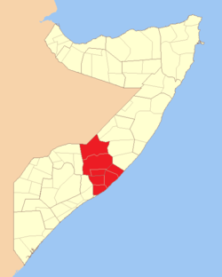
The Hirshabelle State is located in the South-Central part of Somalia, and consists of two regions; Hiraan and Middle Shabelle. The name of the state originates from combining these two regions names.

The state is bordered by Galmudug to the north, South West State and Benadir to the south, Ethiopia to the west and the Indian Ocean to the east.

Jowhar is the capital city while Beledweyne is the second biggest city. The main port town is Adale and the state is state is crossed by the Shabelle river which is symbolized in its flag.

Shabelle river ATMIS Support in Beletweyne.jpg
Shabelle river

Climate

In March and April, the average daily maximum temperature in Beledweyne, the capital of Hiraan, is 36.7 °C (98.1 °F). In December, the average daily maximum temperature is 21.9 °C (71.4 °F).

Climate data for Beledweyne, Somalia
MonthJanFebMarAprMayJunJulAugSepOctNovDecYear
Record high °C (°F)41.5
(106.7)
42.5
(108.5)
43.0
(109.4)
43.0
(109.4)
41.3
(106.3)
39.0
(102.2)
39.0
(102.2)
39.0
(102.2)
40.2
(104.4)
45.0
(113.0)
40.0
(104.0)
42.0
(107.6)
45.0
(113.0)
Mean daily maximum °C (°F)34.5
(94.1)
35.4
(95.7)
36.7
(98.1)
36.9
(98.4)
34.9
(94.8)
34.0
(93.2)
33.0
(91.4)
33.8
(92.8)
35.3
(95.5)
34.4
(93.9)
34.8
(94.6)
34.5
(94.1)
34.8
(94.6)
Daily mean °C (°F)28.2
(82.8)
28.7
(83.7)
30.0
(86.0)
30.4
(86.7)
29.2
(84.6)
28.4
(83.1)
27.8
(82.0)
27.7
(81.9)
29.0
(84.2)
28.7
(83.7)
28.5
(83.3)
28.5
(83.3)
28.7
(83.7)
Mean daily minimum °C (°F)22.0
(71.6)
22.0
(71.6)
23.4
(74.1)
23.9
(75.0)
23.4
(74.1)
22.8
(73.0)
22.6
(72.7)
21.6
(70.9)
22.7
(72.9)
22.6
(72.7)
22.3
(72.1)
22.3
(72.1)
22.6
(72.7)
Record low °C (°F)16.0
(60.8)
16.5
(61.7)
17.0
(62.6)
16.0
(60.8)
18.0
(64.4)
17.0
(62.6)
17.0
(62.6)
16.3
(61.3)
17.2
(63.0)
17.0
(62.6)
15.0
(59.0)
15.0
(59.0)
15.0
(59.0)
Average precipitation mm (inches)0
(0)
1
(0.0)
5
(0.2)
48
(1.9)
59
(2.3)
6
(0.2)
3
(0.1)
3
(0.1)
8
(0.3)
51
(2.0)
16
(0.6)
5
(0.2)
204
(8.0)
Average precipitation days (≥ 1.0 mm)00055000042020
Average relative humidity (%)58575760646165645964636261
Mean monthly sunshine hours 288.3276.9288.3243.0272.8249.0201.5232.5246.0223.2243.0269.73,034.2
Mean daily sunshine hours 9.39.89.38.18.88.36.57.58.27.28.18.78.3
Percentage possible sunshine 80796553546154626257606963
Source 1: Deutscher Wetterdienst [7]
Source 2: Food and Agriculture Organization: Somalia Water and Land Management (per cent sunshine) [8]

References

  1. "Somalia: Subdivision and cities". www.citypopulation.de. Archived from the original on 25 April 2024. Retrieved 14 February 2024.
  2. 1 2 "Somali Health And Demographic Survey: Hirshabelle Report" (PDF).{{cite journal}}: Cite journal requires |journal= (help)
  3. "Baarlamaanka Hirshabeele oo madaxweyne doortay — BBC News Somali". Archived from the original on 9 April 2023. Retrieved 17 November 2020.
  4. "Hirshabelle: Cali Cabdullaahi Cosoble oo la Riday iyo Cali Guudlaawe oo Madaxweyne KMG noqday (dhegayso)". Radio Daljir (in Somali). 14 August 2017. Retrieved 12 November 2020.
  5. "HirShabeelle oo yeelatay madaxweyne cusub — BBC News Somali". Archived from the original on 9 April 2023. Retrieved 17 November 2020.
  6. "iftiin fm – ileyska ummadda". Archived from the original on 17 March 2022. Retrieved 15 November 2020.
  7. "Klimatafel von Beled Weyne (Belet Uen) / Somalia" (PDF). Baseline climate means (1961–1990) from stations all over the world (in German). Deutscher Wetterdienst. Archived (PDF) from the original on 12 April 2020. Retrieved 22 October 2016.
  8. "Long term mean monthly sunshine fraction in Somalia". Food and Agriculture Organization. Archived from the original on 5 October 2016. Retrieved 4 November 2016.